
Clyde Defences, Portkil Battery, Battery Observation Post, Electric Light Director Post, Fire Control Post


Observation Post(S) (20th Century), Observation Post(S) (First World War)
Site Name Clyde Defences, Portkil Battery, Battery Observation Post, Electric Light Director Post, Fire Control Post
Classification Observation Post(S) (20th Century), Observation Post(S) (First World War)
Alternative Name(s) Fort Road
Canmore ID 331706
Site Number NS28SE 39.03
NGR NS 24893 80560
Datum OSGB36 - NGR
Permalink http://canmore.org.uk/site/331706


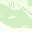


- Council Argyll And Bute
- Parish Rosneath
- Former Region Strathclyde
- Former District Dumbarton
- Former County Dunbartonshire
The pre-1914 and wartime plans of the site suggest that the Battery Observation Post (and the Electric Light Director Post) was at first between the two 6-inch guns, and later in a separate building slightly uphill and behind the 6-inch guns. A Fire Command Post was built adjacent to the E side of the Battery Observation Post.
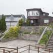
The Battery Observation Post is still extant. The Fire Command post may have been destroyed or incorporated into a modern house.
Information from HS/RCAHMS World War One Audit Project (GJB) and RCAHMS (AKK) 5 July 2013.
Project (March 2013 - September 2013)
A project to characterise the quantity and quality of the Scottish resource of known surviving remains of the First World War. Carried out in partnership between Historic Scotland and RCAHMS.
Field Visit (17 May 2016)
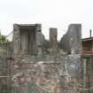
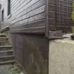
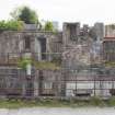
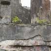
Two buildings, comprising the Battery Observation Post (BOP) and the Fire Command Post, stand immediately to the rear and N of the 6-inch gun emplacements (NS28SE 39.01). The brick-and-concrete BOP is the westerly of the two and is a two-storey building which replaced the BOP that was situated on the platform between the two 6-inch guns. As proposed in a plan dated 16 October 1908 (National Archives: WO 78/5184), the lower floor contained two rooms and the upper floor housed the Battery Command Post and the DEL (Directing Electric Light) Post, with windows looking S over the gun emplacements. Access to the upper level was by an external staircase on the E elevation. As depicted on the contemporary plan (National Archives: WO 78/5189), the ground surface on the S and W sides was made up to window level on the upper storey. This embankment was separated from the fully exposed N and E sides of the building by high retaining walls that respectively extended N from the NW corner of the BOP and S from the SE corner. This embankment and its retaining walls have since been removed, a pitched roof added and alterations have been made to the S elevation, with changes to the windows and an extension added.
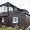
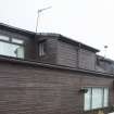
The two-storey brick-and-concrete Fire Command Post (NS 24900 80568) lies immediately to the E of the BOP and has been incorporated into a dwelling. The original L-shaped upper storey with later additions is still visible and it may be that much of the building (as depicted on a proposed plan dated 12/12/13) still survives within the present structure.
Visited by HES Survey and Recording (AM, HS, AKK) 17 May 2016.

