
Clyde Defences, Cloch Point Battery, Control Buildings


Command Post(S) (First World War), Military Observation Site (20th Century), Military Observation Site (Second World War)
Site Name Clyde Defences, Cloch Point Battery, Control Buildings
Classification Command Post(S) (First World War), Military Observation Site (20th Century), Military Observation Site (Second World War)
Alternative Name(s) Cloch Lighthouse; Cloch Plantation
Canmore ID 311127
Site Number NS27NW 21.03
NGR NS 20432 75599
Datum OSGB36 - NGR
Permalink http://canmore.org.uk/site/311127


- Council Inverclyde
- Parish Inverkip
- Former Region Strathclyde
- Former District Inverclyde
- Former County Renfrewshire
NS27NW 21.03 20432 75599
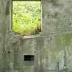
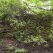
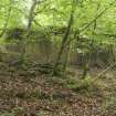
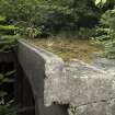
Scheduled as 'Cloch Lighthouse, coast battery 295m SSE of... the remains of the control buildings of the Cloch Point coastal defence battery, dating to the Second World War... consist of two buildings representing the former command and observation posts for the battery. Elements of the gun platforms survive in the nearby caravan park and remains of the related searchlight battery and anti-submarine boom can be found by the shore of the firth. The site is located on a slope overlooking Cloch Point and the Firth of Clyde at around 70m above sea level.'
Information from Historic Scotland, scheduling document dated 29 March 2011.
[Open rectangle]
OS (GIS) MasterMap, June 2011.
Note (3 July 2013)
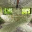
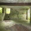
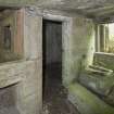
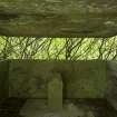
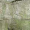
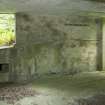
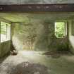
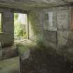
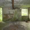
Two building lie to the S of the battery. Both have been identified the former command and observation posts for the battery.
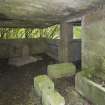
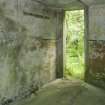
The building to the E is identified on a plan of the proposed battery (The National archives WO78/5185) as the F.C. Post (Fire Command Post) and dates to 1915-16 construction. Two additional extensions have been attached to the N and S sides at a later date.
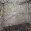
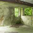
Downhill and to the W lies a second building, probably an observation post. It comprises a three room structure. The S room has a large bay window in the SW corner, with a door to the W leading out to a small balconey.
Information from RCAHMS (AKK) 3 July 2013.
Project (March 2013 - September 2013)
A project to characterise the quantity and quality of the Scottish resource of known surviving remains of the First World War. Carried out in partnership between Historic Scotland and RCAHMS.
Measured Survey (29 February 2016 - 1 March 2016)
HES surveyed the Cloch Point Battery Fire Command Post between 29 February - 1 March 2016 at a scale of 1:00. The resultant ground and first floor plans were redrawn in vector graphics software.
Field Visit (2 March 2016)
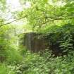
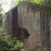
The fire command post of Cloch Battery is situated near the southern boundary of the site, on a knoll that drops steeply to the W and provides a vantage point over the Firth of Clyde. The building was protected by a series of outer defences comprising a barbed wire fence and sentry/machine-gun posts (NS27NW 21.18, 21.28, 21.31 & 21.32).
The building stands on the W edge of a bedrock knoll and it is a split-level structure set into the natural slope. The northern part of the building is the earlier and has an entrance on the E which leads down from the natural ground surface into four compartments. The later, southern, part of the building is a simpler structure with a very narrow entrance on the E leading into a compartment which has once been subdivided from WNW to ESE into two equally-sized rooms.
Visited by HES Survey and Recording (GG, AK, AM) 2 March 2016.

