
Greenock, Clyde Defences, Fort Matilda, Submarine Mining Station, Hms Dalriada


Submarine Mining Station (19th Century), Submarine Mining Station (Second World War), Submarine Mining Station (First World War)
Site Name Greenock, Clyde Defences, Fort Matilda, Submarine Mining Station, Hms Dalriada
Classification Submarine Mining Station (19th Century), Submarine Mining Station (Second World War), Submarine Mining Station (First World War)
Alternative Name(s) Whiteforeland Point; Clyde Submarine Mining Station
Canmore ID 185530
Site Number NS27NE 97
NGR NS 2585 7790
Datum OSGB36 - NGR
Permalink http://canmore.org.uk/site/185530


- Council Inverclyde
- Parish Greenock
- Former Region Strathclyde
- Former District Inverclyde
- Former County Renfrewshire
A submarine mining station was established by the 1880s just to the east of Fort Matilda. Its internal arrangements are shown in some detail of a plan of the Fort in 1895 (The National Archives WO 78/2443). The station was for the purpose of the creation and maintenance of the controlled minefield established across the Clyde from Fort Matilda to Portkil Battery on the north bank. The Palmerston Forts Society suggest that the mining station was closed in 1904, but the station is still mapped and labelled on War Office maps dated 1906.
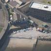
The station was again used in the Second World War. Surviving buildings were reported in 2001 and are still in military use.
Information from HS/RCAHMS World War One Audit Project (GJB) 2 July 2013.
NS27NE 97 2585 7790
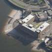
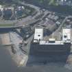
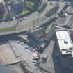
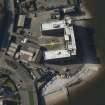
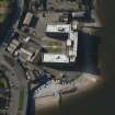
The Clyde Submarine Mining Station is situated on the E side of Fort Matilda and occupies part of the World War I coastal battery site (NS27NE 96).
The pier, huts and other buildings are extant on the E side immediately N of the junction between Eldon Street and the Esplanade.
J Guy 2001; NMRS 810/11, Part 2, 83-4.
Note (2 July 2013)
For pier and slipway see NS27NE 394 and NS27NE 404.
Information from RCAHMS (AKK) 2 July 2013
Project (March 2013 - September 2013)
A project to characterise the quantity and quality of the Scottish resource of known surviving remains of the First World War. Carried out in partnership between Historic Scotland and RCAHMS.

