
Pricing Change
New pricing for orders of material from this site will come into place shortly. Charges for supply of digital images, digitisation on demand, prints and licensing will be altered.
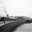
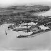
Ardrossan Harbour


Harbour (Period Unassigned)
Site Name Ardrossan Harbour
Classification Harbour (Period Unassigned)
Alternative Name(s) Montgomerie Pier; Winton Pier; Firth Of Clyde
Canmore ID 41129
Site Number NS24SW 36
NGR NS 22585 42219
NGR Description Centred NS 22585 422219
Datum OSGB36 - NGR
Permalink http://canmore.org.uk/site/41129


- Council North Ayrshire
- Parish Ardrossan
- Former Region Strathclyde
- Former District Cunninghame
- Former County Ayrshire
NS24SW 36.00 centred 22585 422219
Ship Ferry (Vehicular) Terminal [NAT] (centred NS 2248 4282)
OS 1:10,000 map, 1981.
Harbour [NAT] (at NS 22478 42266)
OS (GIS) AIB, May 2006.
NS24SW 36.01 NS 22516 42236 Outer Harbour (dock)
NS24SW 36.02 NS 22688 42188 Inner Harbour (dock)
NS24SW 36.03 NS 22231 42241 Fog Signal and Lighthouse [Ardrossan 1]
NS24SW 36.04 NS 22150 42738 to NS 22105 42651 to NS 22164 42348 Detached Breakwater (Crinan Rock)
NS24SW 36.05 NS 22489 42174 Ferry Terminal
NS24SW 36.06 NS 22556 43328 Montgomerie Pier
NS24SW 36.07 NS 22588 42292 Montgomerie Pier, Harbour Master's Office
NS24SW 36.08 NS 22413 42225 Winton Pier
NS24SW 36.09 NS 22373 42105 Ferry Terminal
NS24SW 36.10 NS 22384 42092 Old Dock, entrance lock
NS24SW 36.11 NS 22479 42038 Old Dock
NS24SW 36.12 NS 22476 41946 Old Dock, graving dock
NS24SW 36.13 NS 22164 42349 Detached Breakwater (Crinan Rock), Beacon [Ardrossan 2]
NS24SW 36.14 NS 22747 42053 Old Power House (Hydraulic Power Station)
NS24SW 36.15 NS 22230 42251 to NS c. 22243 42148 South Pier
NS24SW 36.16 NS 22599 42260 Draw Bridge (between Inner and Outer Harbours)
See also:
NS24SW 32 Centred NS 2353 4242 Ardrossan, Burgh
NS24SW 33 NS 22808 42018 Custom House
NS24SW 34 Centred NS 2264 4220 Shipyard
NS24SW 51 NS 2242 4220 Winton Pier Station and Ardrossan Harbour Station
NS24SW 52 NS 2257 4231 Montgomerie Pier Station
NS24SW 227 NS 21288 42560 Horse Island, Beacon
Location formerly entered as NS 225 422.
EXTERNAL REFERENCE
Scottish Record Office
Building of the South Pier of the Harbour of Ardrossan. Letter from the Earl of Eglington reports that stone has begun to be raised and materials prepared for the work which is to be finished next Summer.
1805 GD109/3847/11
(Undated) information in NMRS.
(Location cited as NS 22 42). Ardrossan Harbour, built 1806 on, by the 12th and 13th Earls of Eglinton. A natural harbour, greatly improved. Until recently there were three basins, one locked, but the latter is now being filled in. Between 1886 and 1891, the Eglinton Dock, an outer basin, and a new breakwater were constructed by the Ardrossan Harbour Company. The machinery is now virtually all modern.
J R Hume 1976.
(Location cited as NS 22 41 and NS 22 42). Ardrossan stands on a promontory which projects about a mile [1.6km] into the Firth of Clyde, having on one side the bag-shaped North Bay [name: NS 225 430] and being separated by the open South Bay [name: NS 235 415] from the headland occupied by Saltcoats [Harbour: NS24SW 44.00]. Given additional protection by Horse Island [name: NS 213 426] and some other rocks, the North Bay is generally sheltered from all directions except the SW, and served as a place of refuge.
The construction of a harbour was projected by the 12th Earl of Eglinton with the objective of its becoming the port of Glasgow, cutting out the navigation of the (then-unimproved) Clyde estuary. He was also interested in the exploitation of the local coal and ironstone, in the improvement of his estates and in the development of the town of Ardrossan [NS24SW 32]. The work was authorised by an Act of 1805, which also covered a canal to Glasgow. Of this latter, only the section [NS56SE 1579.00] from Glasgow (Port Eglinton) to Johnstone was built. Funds were obtained from shareholders, and the earl himself spent £100,000 on the project.
Operations seem to have started with little delay, as by 1807 a curved pier 900ft [274m] had been completed under the direction of John Simpson. Between 1808 and 1812, suggestions for further work were made by several engineers: Jessop (1808), Rennie and Whidbey (1811) and Telford (1812). The last recommended construction of a wet dock of 6.5 acres [2.63ha] giving 19ft [5.8m] depth of water, but no action was taken as all the plans were ambitious and there was a pause following the earl's death in 1819. In 1839, J Walker recommended the completion of a wet dock [presumably NS24SW 36.11], with an entrance capable of admitting the largest steamers on the Clyde. This was authorised by an Act of 1841, and was completed by 1846. The resulting complex comprised two tidal basins [presumably NS24SW 36.01 and NS24SW 36.02], respectively 200yds [182.9m] and 300yds [274.4m] in length, with quays which gave depths of from 10 to 21ft [3m to 6.4m] at high springs; a dry dock of 3.75 acres [1.51 ha], with 500yds [457.3m] of quay giving a depth of 20ft [6.1m]; a graving dock [presumably NS24SW 36.12] giving 14ft [4.3m], with a patent slip, sheds, cranes, facilities for shipbuilding, and two leading lights. An unlighted beacon-tower [NS24SW 227] was also built on Horse Island. Steamers are recorded as running to Arran, Ayr, Glasgow and Stranraer in 1837, and to Belfast in 1840.
In spite of far-reaching changes resulting from the industrial developments of the 19th and 20th centuries, the main features of these earlier plans persist. The chief of these is the long pier that covers the whole of the W and SW sector of the site. On its inner side, this appears as a massive sea-wall, with a parapet standing up to 6ft [1.8m] above a parapet-walk, to which access is obtained by steps. Externally, the foundations are seen to follow the dispositions of the underlying rock, with the outer wall-face sweeping up from a widely-flared base. Within the pier, there lies a large dock [NS24SW 36.11], presumably the 'wet' dock of 1846, which is now in process of being filled up with rubbish. Its entrance-passage and dock-gates have been overbuilt by the terminal works of the Arran and Belfast ferries, but the eastern jamb of the inner end of the passage is still free of the filling, and the position of the western one can be inferred. NE of this dock, and beyond the spur of railway leading to the ferry terminals, are two basins [NS24SW 36.01 and NS24SW 36.02 ] separated by a pier; the passage between them is spanned by a dock-gate. A difference in date between this pier and the dock now being filled up is suggested by a difference in the styles of their respective bollards.
A Graham 1984.
Construction (1806 - 1819)
Earl of Eglington approached Telford in 1804 (and later Jessop worked on project). South pier900 yards in length built 1806-1809. By 1815, overbudget. Works stopped 1819 on death of 12th Earl of Eglington.
Construction (1833 - 1892)
13th earl of Eglinton completes original 1804 plans on reduced scale. Two tidal basins, wet dock. Dry Dock built 1846. 1886-92, Eglinton Dock built.
R Paxton and J Shipway 2007
Project (2007)
This project was undertaken to input site information listed in 'Civil engineering heritage: Scotland - Lowlands and Borders' by R Paxton and J Shipway, 2007.
Publication Account (2007)
In 1804 Telford was approached by the 12th Earl of Eglinton to examine the project of a canal from Glasgow to his Ardrossan estate where he proposed a great harbour to serve Glasgow (LIN 25). Telford, later supported by Jessop, planned a harbour with an area sufficient to accommodate 100 vessels. Two piers were planned embracing an entrance lock to a spacious wet dock at the shore end of which was to be the canal entrance. Work began in 1806 and by early 1809 the southern curved pier about 900 yards long had been built [see later plan showing the pier carrying a railway, 289). Construction turned out to be more difficult and expensive than anticipated. By 1815 Rennie had also been consulted and £70 000 had been spent against the original estimate of £40 000. Rennie estimated that £90 000 would be required.
The work came to a standstill on the death of the Earl in 1819 and was not resumed until 1833 under the 13th Earl when it was completed on a reduced scale. The harbour then comprised two tidal basins of 6 and 18 acres and a wet dock of 4 acres with 19 ft of water over the sill at high water (see plan, 289). A dry dock was built in 1846.
From 1886–92 the 10-acre Eglinton Dock was built which increased the depth of water to 27 ft at high tide. An outer tidal basin was also formed which included a new breakwater 1320 ft long. The engineer for these improvements was Robert Robertson.
In later years the harbour was developed to serve shipping interests on the Clyde and is in use today by the oil industry and other shipping, including the Arran ferry, and as a marina.
R Paxton and J Shipway 2007
Reproduced from 'Civil Engineering heritage: Scotland - Lowlands and Borders' with kind permission of Thomas Telford Publishers.

