
Knockjargon


Cairn (Period Unassigned)
Site Name Knockjargon
Classification Cairn (Period Unassigned)
Canmore ID 41015
Site Number NS24NW 27
NGR NS 2355 4730
Datum OSGB36 - NGR
Permalink http://canmore.org.uk/site/41015


- Council North Ayrshire
- Parish Ardrossan
- Former Region Strathclyde
- Former District Cunninghame
- Former County Ayrshire
NS24NW 27 2355 4730
(NS 2355 4730) Cairn (NR)
OS 6" map (1970)
For fort (around cairn), see NS24NW 21.
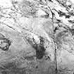
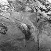
A cairn, about 50ft in diameter, occupies the summit of Knock Jargon (758ft OD).
R W Feachem 1963.
This turf-covered cairn is 15.0m in diameter and 1.6m high.
Visited by OS (DS), 7 September 1956.
No change to previous field report.
Revised at 1:2500.
Visited by OS (WDJ), 25 November 1965.
No change. Although robbed of material, this cairn has retained its form despite occupying a sizeable area of the interior of a small hill fort (NS24NW 21).
Visited by OS (JRL), 11 November 1982.
Field Visit (10 September 1942)
Fort, Knock Georgan, Busbie Muir.
Knock Georgan is a crag on the summit of a hill with a roughly oval summit and precipices on the N. It is enclosed by two stone ramparts both interrupted for an entrance on the S. No built face is exposed, and the debris on the hill flanks is not conspicuous, but just W of the entrance some stones of the foundation course are exposed probably in situ. Both ramparts follow the contours of the crag, the inner one that of the summit and the outer one lower down. It fades out 15' NE of the entrance where the crag is particulalrly steep, but reappears again further N. There are suggestions of a ditch below the outer rampart on the SW.
Near the N end of the inner enciente, at the very summit of the crag, is a grass-grown stony mound about 50' in diameter strongly suggesting a cairn. A trig. station stands upon it.
Visited by RCAHMS 10 September 1942
Excavation (September 1977)
Excavation of Knockjargon fort and cairn by students from the Department of Archaeology, University of Glasgow and members of the Ayrshire Archaeological Society over a period of three weeks in September 1977, with financial assistance from the University of Glasgow and the Society of Antiquaries of Scotland.
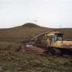
Watching Brief (22 April 2008 - 30 June 2008)
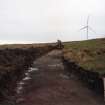
NS 23542 47317 A watching brief was undertaken from 22 April–30 June 2008, during topsoil stripping associated with the erection of three new wind turbines. The site was deemed to be of archaeological interest as the remains of Knock Jargon prehistoric hillfort and cairn, a designated scheduled ancient monument (SAM 305), are near the centre of the site, and upstanding elements of possible medieval cultivation practices are also preserved within its boundaries.
As part of the works, upstanding features potentially affected by groundworks were fenced to prevent any accidental damage during excavations. No further archaeological features or deposits were identified during the course of works. This was considered to reflect a genuine absence of below-ground features in the monitored areas, rather than their destruction.
Archive: RCAHMS
Funder: Airtricity
Kate Bain (Headland Archaeology Ltd), 2008

