
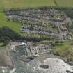
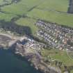
Dunure Harbour


Harbour (Period Unassigned)
Site Name Dunure Harbour
Classification Harbour (Period Unassigned)
Alternative Name(s) Port Rorie; Firth Of Clyde; Outer Clyde Estuary
Canmore ID 151682
Site Number NS21NE 24
NGR NS 25439 16034
NGR Description Centred NS 25439 16034
Datum OSGB36 - NGR
Permalink http://canmore.org.uk/site/151682


- Council South Ayrshire
- Parish Maybole
- Former Region Strathclyde
- Former District Kyle And Carrick
- Former County Ayrshire
NS21NE 24.00 centred 25439 16034
Location formerly cited as centred NS 25479 16030.
NS21NE 24.01 NS 25419 16060 to NS c. 25393 16013 West (South) Pier
NS21NE 24.02 NS 25450 16042 to NS c. 25484 16028 East (Central) Pier
NS21NE 24.03 NS c. 25420 16056 West (South) Pier, Light-tower
NS21NE 24.04 NS 25388 16051 to NS 25367 16035 to NS c. 25367 16012 West (South) Breakwater
NS21NE 24.05 NS 25390 16116 to NS 25377 16101 to NS c. 25477 16066 North Breakwater
See also:
NS21NE 46 Centred NS 25423 15971 1-19 Harbour View (Cottages)
Harbour [NAT] (at NS 2242 1602)
OS (GIS) AIB, June 2006.
NMRS REFERENCE
NMRS survey of documents relating to Dunure Harbour including accounts for expenditure on New Harbour 1810-1814; Act of Parliament 6th May 1811; and printed proposals for improvement 1897.
Copied 1980 Inventory 111.
(Undated) information in NMRS.
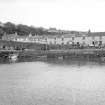
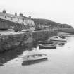
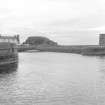
(Location cited as NS 254 160). Dunure Harbour, built 1811. A small rectangular basin formed by two straight rubble piers with rounded ends. The landward sides are partly rock-cut. There is also a rubble breakwater to protect the entrance from northerly winds. At the seaward end of the longer pier is a small circular light-tower, much eroded. Other features are a series of wooden frames for net drying, and a 2-storey range of fishermen's cottages on the S quay.
J R Hume 1976.
(Location cited as NS 254 161). Dunure was one of the sites at which Tucker reported a 'creek' in 1655, presumably using this word in the sense of a subordinate customs-post. Improvement seems to have begun about 1811, when a small secure basin was contrived with an entrance channel 50ft [15.2m] wide cut through rock. By 1837, however, dilapidation had set in, and Groome remarked in 1886 that the harbour proved of small value and had been allowed to go into decay.
This somewhat slight account of the harbour's development can, however, be considerably expanded by observation on the spot and by reference to the OS maps of 1856 and 1968. The existing major feature of the site, as presented to the view of an observer on the high rocky lump that overlooks them from the SW, comprise a rectangular basin measuring 230ft [70.1m] by 160ft [48.8m] and bordered on the S and E (more exactly SSW and ESE) by wharfage, on the W by a breakwater, and on the N by a pier and a structure bearing a light-tower [NS21NE 24.03].
The harbour's entrance [location: NS 2542 1606], 120ft [36.6m] wide, opens between this structure and the end of the N pier. This entrance, in turn, opens from an east-going inlet, itself bordered on the N by a rocky projection; at its narrowest part, the inlet today measures 60ft [18.3m] in width between the high-tide contours, a figure which corresponds significantly with the 50ft [15.2m] rock-cut entrance of 1811. It is true that no signs of rock-cutting could be detected here, but they may well have been erased by the friction of the waves or been covered by invading sand; and no evidence was found to support Aiton's statement that the whole inlet, some 760ft [231.7m] long was an artificial cutting in the rock. The expanded end of the W breakwater, which carries the light-tower [NS21NE 24.03], is ruinous; its seaward portion has been patched, but on the E it retains a rounded shape and faces across the entrance to the similarly rounded end of the N pier. All these works are of good limestone rubble, squared and well coursed, but the tower, in particular, is very heavily weathered. Both the tower and the N pier carry ornamental string-courses of a style which would agree very well with a date in the early years of the 19th century. The entrance to the tower is closed by an iron door, carefully curved to accord with the curved outline of the building. A local guide-book [no reference cited] states that the tower was never lighted.
So far so good, but some further features of the site remain for explanation, and it is also necessary to account for the place-name Port Rorie, which is marked on the map of 1856 at a point immediately beyond the SW corner of the basin. The shoreline here, though gently indented, is rock-bound, and seems today to offer no natural shelter other than what may be afforded by a large off-shore rock. It thus seems possible that an old Port Rorie existed before 1811 in the form of a natural inlet, occupying part of the site of the existing basin and entered from the sea by a passage now blocked by the W breakwater. In support of this suggestion, at least three considerations may be put forward. The W breakwater contains an early component, only visible when low tide uncovers its base, and this would have had precisely the suggested effect. Again, when the SW entry was closed, a new entry into the harbour area would obviously have been needed, and this would have led to the cutting-out of a channel in the narrow throat of the N inlet, as recorded in the Parliamentary Report. In the third place, a rock just W of the presumed site of Port Rorie is named suggestively 'Perrorie ' in the local guide-book.
To carry structural analysis beyond this point is, however, made difficult by reason of later improvements. The OS map of 1968 marks additional stretches of breakwater, identifiable today as built masonry or, at the higher levels where wave action has been most destructive, perhaps only as displaced facing-blocks. The longest of these stretches is marked along the N side of the outer inlet, where remains of what is probbaly work of an earlier phase appear clearly in the footings, and where the date '1909' has been traced on a patch of wet cement. Other stretches are on the outer side of the N pier, and across the suggested former site of Port Rorie, more or less along highwater mark.
In 1847, when the Parliamentary Report was drawn up, Dunure supported twenty fishing boats. On occasion, the fishermen of that day carried cargoes of lime and bone-dust from Ireland. Smuggling had flourished in the district in earlier years, but by 1837 was said to have been almost entirely abandoned, except for some soap from Ireland and whisky from Arran.
A Graham 1984.
Graham also notes Port Rorie at cited location NS 254 161. This is presumably on account of its being a 'Port' place-name.
Information from RCAHMS (RJCM), 30 June 2006.
Photographed on behalf of the Buildings of Scotland publication (2009).

