
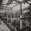
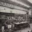
Inverkip Power Station


Power Station (20th Century)
Site Name Inverkip Power Station
Classification Power Station (20th Century)
Alternative Name(s) Inverkip, Power Station And Jetty; Firth Of Clyde
Canmore ID 68124
Site Number NS17SE 5
NGR NS 19670 71030
NGR Description Centred NS 19670 71030
Datum OSGB36 - NGR
Permalink http://canmore.org.uk/site/68124
Ordnance Survey licence number AC0000807262. All rights reserved.
Canmore Disclaimer.
© Copyright and database right 2024.
- Correction
- Favourite

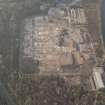
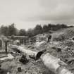
DP 175440
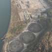
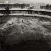
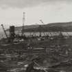
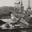
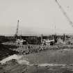
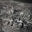
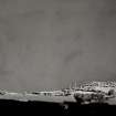
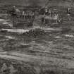
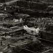
General oblique aerial view of the remains of Inverkip power station during post-demolition clearance, looking to the NNE.
RCAHMS Aerial Photography Digital
30/1/2014
© Crown Copyright: HES

DP 175449
Oblique aerial view of the remains of Inverkip power station during post-demolition clearance, looking to the NNW.
RCAHMS Aerial Photography Digital
30/1/2014
© Crown Copyright: HES

SC 2144440
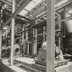
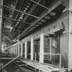
Image from photo album titled 'Inverkip'
Scottish Power
18/5/1970
© Courtesy of HES (Scottish Power Collection)

SC 2144451
Image from photo album titled 'Inverkip'
Scottish Power
18/5/1970
© Courtesy of HES (Scottish Power Collection)

SC 2144454
Image from photo album titled 'Inverkip'
Scottish Power
18/5/1970
© Courtesy of HES (Scottish Power Collection)

SC 2144470
Image from photo album titled 'Inverkip'
Scottish Power
18/5/1970
© Courtesy of HES (Scottish Power Collection)

SC 2144473
Image from photo album titled 'Inverkip'
Scottish Power
13/9/1971
© Courtesy of HES (Scottish Power Collection)

SC 2144479
Image from photo album titled 'Inverkip'
Scottish Power
23/4/1971
© Courtesy of HES (Scottish Power Collection)

SC 2144485
Image from photo album titled 'Inverkip'
Scottish Power
23/4/1971
© Courtesy of HES (Scottish Power Collection)

SC 2144501
Image from photo album titled 'Inverkip'
Scottish Power
23/4/1971
© Courtesy of HES (Scottish Power Collection)

SC 2144506
Image from photo album titled 'Inverkip'
Scottish Power
18/11/1971
© Courtesy of HES (Scottish Power Collection)

SC 2144531
Image from photo album titled 'Inverkip'
Scottish Power
13/9/1971
© Courtesy of HES (Scottish Power Collection)

SC 2144533
Image from photo album titled 'Inverkip'
Scottish Power
13/9/1971
© Courtesy of HES (Scottish Power Collection)

SC 2144549
Image from photo album titled 'Inverkip'
Scottish Power
18/11/1971
© Courtesy of HES (Scottish Power Collection)

SC 2144555
Image from photo album titled 'Inverkip'
Scottish Power
18/11/1971
© Courtesy of HES (Scottish Power Collection)

SC 2144556
Image from photo album titled 'Inverkip'
Scottish Power
18/11/1971
© Courtesy of HES (Scottish Power Collection)

SC 2144562
Image from photo album titled 'Inverkip'
Scottish Power
18/11/1971
© Courtesy of HES (Scottish Power Collection)

SC 2144565
Image from photo album titled 'Inverkip'
Scottish Power
18/11/1971
© Courtesy of HES (Scottish Power Collection)

SC 2144566
Image from photo album titled 'Inverkip'
Scottish Power
18/11/1971
© Courtesy of HES (Scottish Power Collection)

SC 2144569
Image from photo album titled 'Inverkip'
Scottish Power
18/11/1971
© Courtesy of HES (Scottish Power Collection)

SC 2144571
Image from photo album titled 'Inverkip'
Scottish Power
18/11/1971
© Courtesy of HES (Scottish Power Collection)

SC 2144572
Image from photo album titled 'Inverkip'
Scottish Power
18/11/1971
© Courtesy of HES (Scottish Power Collection)

SC 2144578
Image from photo album titled 'Inverkip'
Scottish Power
18/11/1971
© Courtesy of HES (Scottish Power Collection)

SC 2144586
Image from photo album titled 'Inverkip'
Scottish Power
18/11/1971
© Courtesy of HES (Scottish Power Collection)

SC 2144597
Image from photo album titled 'Inverkip'
Scottish Power
18/11/1971
© Courtesy of HES (Scottish Power Collection)

SC 2144607
Image from photo album titled 'Inverkip'
Scottish Power
18/11/1971
© Courtesy of HES (Scottish Power Collection)

SC 2144614
Image from photo album titled 'Inverkip'
Scottish Power
18/11/1971
© Courtesy of HES (Scottish Power Collection)

SC 2144623
Image from photo album titled 'Inverkip'
Scottish Power
18/11/1971
© Courtesy of HES (Scottish Power Collection)

SC 2144624
Image from photo album titled 'Inverkip'
Scottish Power
18/11/1971
© Courtesy of HES (Scottish Power Collection)

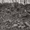
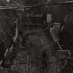
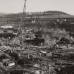
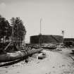
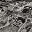
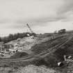
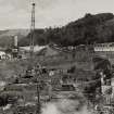
SC 2144642
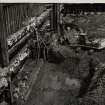
Image from photo album titled 'Inverkip', No. KP 169A, Seal Pit
Scottish Power
14/3/1972
© Courtesy of HES (Scottish Power Collection)

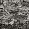
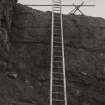
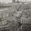
SC 2144649
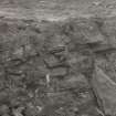
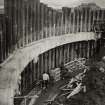
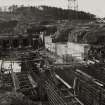
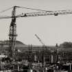
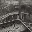
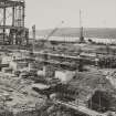
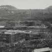
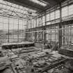
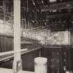
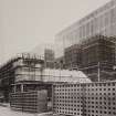
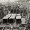
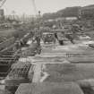
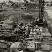
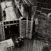
Image from photo album titled 'Inverkip', No. KP 177A, Boiler House Column Foundations
Scottish Power
11/4/1972
© Courtesy of HES (Scottish Power Collection)

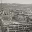
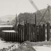
SC 2144653
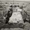
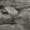
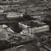
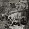
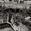
Image from photo album titled 'Inverkip', No. KP 180A, No. 3 C.W. Block Foundations
Scottish Power
11/4/1972
© Courtesy of HES (Scottish Power Collection)

SC 2144657
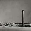
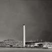
Image from photo album titled 'Inverkip', No. KP 184A, Chimney
Scottish Power
11/4/1972
© Courtesy of HES (Scottish Power Collection)

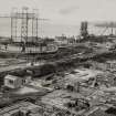
SC 2144659
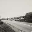
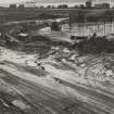
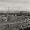
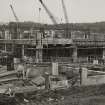
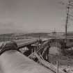
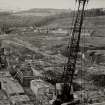
Image from photo album titled 'Inverkip', No. KP 186, View of North end of site looking West
Scottish Power
11/4/1972
© Courtesy of HES (Scottish Power Collection)

SC 2144675
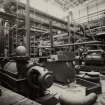
Image from photo album titled 'Inverkip', No. KP 157A, No. 3 T/A
Scottish Power
14/3/1972
© Courtesy of HES (Scottish Power Collection)

SC 2144680
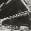
Image from photo album titled 'Inverkip'
Scottish Power
5/1972
© Courtesy of HES (Scottish Power Collection)

SC 2144681
Image from photo album titled 'Inverkip'
Scottish Power
5/1972
© Courtesy of HES (Scottish Power Collection)

SC 2144706
Image from photo album titled 'Inverkip'
Scottish Power
5/1972
© Courtesy of HES (Scottish Power Collection)

SC 2144707
Image from photo album titled 'Inverkip'
Scottish Power
10/8/1974
© Courtesy of HES (Scottish Power Collection)

SC 2144722
Image from photo album titled 'Inverkip'
Scottish Power
6/1974
© Courtesy of HES (Scottish Power Collection)

SC 2144753
Image from photo album titled 'Inverkip'
Scottish Power
6/1974
© Courtesy of HES (Scottish Power Collection)

SC 2144761
Image from photo album titled 'Inverkip'
Scottish Power
6/1974
© Courtesy of HES (Scottish Power Collection)

SC 2144767
Image from photo album titled 'Inverkip'
Scottish Power
27/8/1974
© Courtesy of HES (Scottish Power Collection)

SC 2144787
Image from photo album titled 'Inverkip'
Scottish Power
27/8/1974
© Courtesy of HES (Scottish Power Collection)

SC 2144789
Image from photo album titled 'Inverkip'
Scottish Power
27/8/1974
© Courtesy of HES (Scottish Power Collection)

SC 2144793
Image from photo album titled 'Inverkip'
Scottish Power
27/8/1974
© Courtesy of HES (Scottish Power Collection)

SC 2144819
Image from photo album titled 'Inverkip'
Scottish Power
5/11/1974
© Courtesy of HES (Scottish Power Collection)

SC 2144821
Image from photo album titled 'Inverkip'
Scottish Power
5/11/1974
© Courtesy of HES (Scottish Power Collection)

SC 2144822
Image from photo album titled 'Inverkip'
Scottish Power
5/11/1974
© Courtesy of HES (Scottish Power Collection)

SC 2144827
Image from photo album titled 'Inverkip'
Scottish Power
5/11/1974
© Courtesy of HES (Scottish Power Collection)

SC 2144846
Image from photo album titled 'Inverkip'
Scottish Power
4/2/1975
© Courtesy of HES (Scottish Power Collection)

SC 2144854
Image from photo album titled 'Inverkip'
Scottish Power
4/2/1975
© Courtesy of HES (Scottish Power Collection)

SC 2144867
Image from photo album titled 'Inverkip'
Scottish Power
4/2/1975
© Courtesy of HES (Scottish Power Collection)

SC 2144874
Image from photo album titled 'Inverkip'
Scottish Power
4/2/1975
© Courtesy of HES (Scottish Power Collection)

SC 2144884
Image from photo album titled 'Inverkip'
Scottish Power
4/2/1975
© Courtesy of HES (Scottish Power Collection)

SC 2144909
Image from photo album titled 'Inverkip'
Scottish Power
27/5/1975
© Courtesy of HES (Scottish Power Collection)

SC 2144920
Image from photo album titled 'Inverkip'
Scottish Power
27/5/1975
© Courtesy of HES (Scottish Power Collection)

SC 2144931
Image from photo album titled 'Inverkip'
Scottish Power
27/5/1975
© Courtesy of HES (Scottish Power Collection)

SC 2159468
Image from untitled photo album
Scottish Power
27/5/1971
© Courtesy of HES (Scottish Power Collection)

SC 2159488
Image from untitled photo album
Scottish Power
27/5/1971
© Courtesy of HES (Scottish Power Collection)

SC 2159489
Image from untitled photo album
Scottish Power
27/5/1971
© Courtesy of HES (Scottish Power Collection)

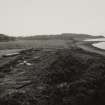
SC 2164714
Image from photo album titled 'Inverkip Power Station'
Scottish Power
© Courtesy of HES (Scottish Power Collection)

SC 2164715
Image from photo album titled 'Inverkip Power Station'
Scottish Power
© Courtesy of HES (Scottish Power Collection)

SC 2164723
Image from photo album titled 'Inverkip Power Station'
Scottish Power
© Courtesy of HES (Scottish Power Collection)

SC 2164725
Image from photo album titled 'Inverkip Power Station'
Scottish Power
© Courtesy of HES (Scottish Power Collection)

SC 2164736
Image from photo album titled 'Inverkip Power Station'
Scottish Power
© Courtesy of HES (Scottish Power Collection)

SC 2164737
Image from photo album titled 'Inverkip Power Station'
Scottish Power
© Courtesy of HES (Scottish Power Collection)

SC 2164741
Image from photo album titled 'Inverkip Power Station'
Scottish Power
© Courtesy of HES (Scottish Power Collection)

SC 2164770
Image from photo album titled 'Inverkip Power Station'
Scottish Power
© Courtesy of HES (Scottish Power Collection)

SC 2164775
Image from photo album titled 'Inverkip Power Station'
Scottish Power
© Courtesy of HES (Scottish Power Collection)

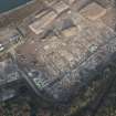
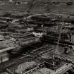
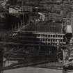
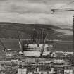
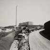
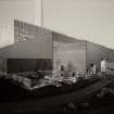
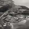
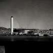
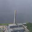
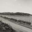
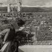
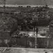
DP 143984
Oblique aerial view of Inverkip Power Station, looking NW.
RCAHMS Aerial Photography Digital
11/7/2012
© Crown Copyright: HES

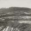
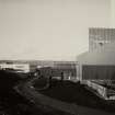
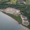
DP 175437
Oblique aerial view of the remains of Inverkip power station during post-demolition clearance, looking to the WSW.
RCAHMS Aerial Photography Digital
30/1/2014
© Crown Copyright: HES

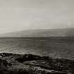
DP 281530
Oblique aerial view.
Historic Environment Scotland
16/7/2018
© Historic Environment Scotland

SC 2144391
Image from photo album titled 'Inverkip'
Scottish Power
18/5/1970
© Courtesy of HES (Scottish Power Collection)

SC 2144441
Image from photo album titled 'Inverkip'
Scottish Power
18/5/1970
© Courtesy of HES (Scottish Power Collection)

SC 2144447
Image from photo album titled 'Inverkip'
Scottish Power
18/5/1970
© Courtesy of HES (Scottish Power Collection)

SC 2144450
Image from photo album titled 'Inverkip'
Scottish Power
18/5/1970
© Courtesy of HES (Scottish Power Collection)

SC 2144460
Image from photo album titled 'Inverkip'
Scottish Power
18/5/1970
© Courtesy of HES (Scottish Power Collection)

SC 2144461
Image from photo album titled 'Inverkip'
Scottish Power
18/5/1970
© Courtesy of HES (Scottish Power Collection)

SC 2144463
Image from photo album titled 'Inverkip'
Scottish Power
18/5/1970
© Courtesy of HES (Scottish Power Collection)

SC 2144467
Image from photo album titled 'Inverkip'
Scottish Power
18/5/1970
© Courtesy of HES (Scottish Power Collection)

SC 2144478
Image from photo album titled 'Inverkip'
Scottish Power
23/4/1971
© Courtesy of HES (Scottish Power Collection)

SC 2144482
Image from photo album titled 'Inverkip'
Scottish Power
23/4/1971
© Courtesy of HES (Scottish Power Collection)

SC 2144483
Image from photo album titled 'Inverkip'
Scottish Power
23/4/1971
© Courtesy of HES (Scottish Power Collection)

SC 2144498
Image from photo album titled 'Inverkip'
Scottish Power
23/4/1971
© Courtesy of HES (Scottish Power Collection)

SC 2144512
Image from photo album titled 'Inverkip'
Scottish Power
13/9/1971
© Courtesy of HES (Scottish Power Collection)

SC 2144514
Image from photo album titled 'Inverkip'
Scottish Power
13/9/1971
© Courtesy of HES (Scottish Power Collection)

SC 2144520
Image from photo album titled 'Inverkip'
Scottish Power
13/9/1971
© Courtesy of HES (Scottish Power Collection)

SC 2144525
Image from photo album titled 'Inverkip'
Scottish Power
13/9/1971
© Courtesy of HES (Scottish Power Collection)

SC 2144537
Image from photo album titled 'Inverkip'
Scottish Power
13/9/1971
© Courtesy of HES (Scottish Power Collection)

SC 2144551
Image from photo album titled 'Inverkip'
Scottish Power
18/11/1971
© Courtesy of HES (Scottish Power Collection)

SC 2144582
Image from photo album titled 'Inverkip'
Scottish Power
18/11/1971
© Courtesy of HES (Scottish Power Collection)

SC 2144585
Image from photo album titled 'Inverkip'
Scottish Power
18/11/1971
© Courtesy of HES (Scottish Power Collection)

SC 2144587
Image from photo album titled 'Inverkip'
Scottish Power
18/11/1971
© Courtesy of HES (Scottish Power Collection)

SC 2144588
Image from photo album titled 'Inverkip'
Scottish Power
18/11/1971
© Courtesy of HES (Scottish Power Collection)

SC 2144600
Image from photo album titled 'Inverkip'
Scottish Power
18/11/1971
© Courtesy of HES (Scottish Power Collection)

SC 2144603
Image from photo album titled 'Inverkip'
Scottish Power
18/11/1971
© Courtesy of HES (Scottish Power Collection)

SC 2144604
Image from photo album titled 'Inverkip'
Scottish Power
18/11/1971
© Courtesy of HES (Scottish Power Collection)

SC 2144608
Image from photo album titled 'Inverkip'
Scottish Power
18/11/1971
© Courtesy of HES (Scottish Power Collection)

SC 2144610
Image from photo album titled 'Inverkip'
Scottish Power
18/11/1971
© Courtesy of HES (Scottish Power Collection)


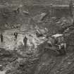
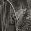
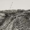
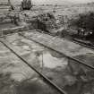
First 100 images shown. See the Collections panel (below) for a link to all digital images.
- Council Inverclyde
- Parish Inverkip
- Former Region Strathclyde
- Former District Inverclyde
- Former County Renfrewshire
NS17SE 5.00 centred 19670 71030
Power Station [NAT]
OS 1:10,000 map, 1980.
Location formerly entered as NS 196 710.
NS17SE 5.01 NS 18876 70884 to NS 19123 70804 Jetty

