
Toward Battery


Command Post (Second World War)
Site Name Toward Battery
Classification Command Post (Second World War)
Canmore ID 352348
Site Number NS16NW 16.01
NGR NS 12258 68114
Datum OSGB36 - NGR
Permalink http://canmore.org.uk/site/352348


- Council Argyll And Bute
- Parish Dunoon And Kilmun
- Former Region Strathclyde
- Former District Argyll And Bute
- Former County Argyll
Field Visit (20 October 2016)
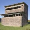
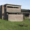
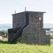
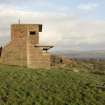
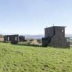
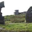
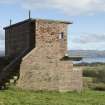
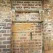
The Battery Observation Post (BOP) is a two-storey building with brick walls and concrete floors and ceilings located 18m NNE of No. 2 gun-house (NS16NW 16.03). It is depicted on a plan contained within the Fort Record Book (National Archives: WO 192/113), which shows that the ground floor space was originally divided into two rooms each with an entrance in the rear (N) wall, the pair protected by a blast wall. Each room was equipped with a stove. The plan notes that the W room housed E.L. Staff (Electric light or searchlights) and the E room B.C. Staff (Battery Command). Later, the dividing wall was removed, the E doorway was bricked up and a porch was created at the rear of the building incorporating the blast wall. This porch, with its lean-to roof, is visible on an aerial photograph (614.C), taken 10-2-1941, therefore the conversion work had been undertaken by that date.
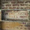
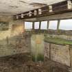
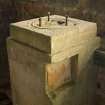
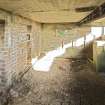
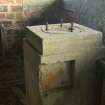
Today, the ground-floor room contains the remains of a raised timber floor that ran along the S side of the room by the windows, with a 1.25m high pillar that once supported a Depression Range Finder set towards the E end. Other fittings include a 1.8m long sloping wooden bench below the windows on the S side, and wooden panels and parts of the conduits for wiring on the E wall. The bricked-up doorway was used as a shelving alcove and a single stove sat in the NE corner of the room, the only remains of it being a hole in the ceiling for its pipe. There is a row of coat hooks on the southern wall of the porch.
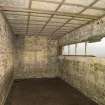
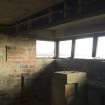
The upper floor was used by the Royal Navy as a signal station and is accessed via an external stairway set against the W elevation. Originally open to the elements, the top of the stair was later provided with a brick porch. The interior of the signal station has a small window in the W elevation and a long window on the S, with the easternmost end of it having been bricked up. The sill of the window bears evidence in two places for mountings for unknown equipment. A stove stood against the rear wall: again all that betrays its original presence is a hole in the ceiling for its pipe. The room was originally wood-lined, with the batons surviving on the roof, and the NW corner had been enclosed for the stove chimney from the room below.
The building controlled the operation of the guns and the searchlights, co-ordinating with the navy signal station which monitored shipping movements in conjunction with the Port War Signal Station near Toward lighthouse (see NS16NW 85). In this context, the mast that once stood immediately to the W (NS16NW 16.25) of the BOP may have been partly used for signalling to ships.
Visited by HES Survey and Recording (JRS, AK, AMcC) 20 October 2016.
Measured Survey (18 October 2016 - 20 October 2016)
HES surveyed Toward Battery Battery Observation Post with students from the Centre for Battlefield Archaeology, University of Glasgow between 18-20 October 2016 with plane-table and alidade at a scale of 1:50. The resultant first and ground floor plans and section were redrawn in vector graphics software at a scale of 1:100.

