
Hunterston Castle


Castle (15th Century), Country House (17th Century)
Site Name Hunterston Castle
Classification Castle (15th Century), Country House (17th Century)
Canmore ID 40646
Site Number NS15SE 1
NGR NS 19285 51471
Datum OSGB36 - NGR
Permalink http://canmore.org.uk/site/40646


- Council North Ayrshire
- Parish West Kilbride
- Former Region Strathclyde
- Former District Cunninghame
- Former County Ayrshire
NS15SE 1 19285 51471
(NS 19285 51471) Hunterston Castle (NR)
OS 6" map (1970).
NMRS REFERENCE
Early 19th Century.
EXTERNAL REFERENCE
Mitchell Library: Graham, Wm, Volume I, c.1870. Photographs P.73
(Undated) information in NMRS.
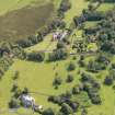
Hunterston Castle was originally situated in an area of marsh, and was defended by a moat and rampart, all of which have now disappeared. It now consists of a rectangular, 16th century, keep, three storeys aand a garret high. A 17th century addition extends to the S, with modern work to the W, the whole forming three sides of a courtyard. The early addition is two storeys and an attic in height, part of it is still occupied.
The building is in excellent preservation, having been renovoated by the late laird General Sir Aylmer Hunter-Weston. The Hunters of Hunterston claim to have been settled here for almost 800 years.
D MacGibbon and T Ross 1889; N Tranter 1965
Hunterston Castle is generally as described. The ground floor of the keep has been converted into a garage by the building of double doors in the N wall.
Visited by OS (DS) 10 September 1956
No change. There is no ground evidence of former earthworks in the vicinity of the castle.
Visited by OS (JRL) 13 December 1982.
NS 1929 5148 In May 2001 an archaeological watching brief was undertaken during site works around Hunterston Castle (NMRS NS15SE 1). The ground was to be reduced by 0.3m and covered with bark chips. On the E side of the castle little was noted as the topsoil was not fully removed in most places. On the N side a demolition layer from the destruction of a modern cottage was noted. On the W side a wall, approximately 1.35-1.40m thick, was noted. It was constructed from large irregularly shaped sandstone blocks and rocks, with a central rubble core. The wall was mortared and set in a shallow foundation trench approximately 0.2m deep. The western extreme of the wall was not located. The archaeological investigation was limited as the wall was remaining in situ, however it appeared that it was later than the castle tower. (GUARD 1016).
Sponsor: John Wetten Brown (Architect) for Madam Pauline Hunter of Hunterston.
L H Johnstone 2001.

