
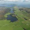
Bute, Loch Quien North


Crannog (Period Unknown), Rotary Quern (Period Unknown)
Site Name Bute, Loch Quien North
Classification Crannog (Period Unknown), Rotary Quern (Period Unknown)
Canmore ID 40234
Site Number NS05NE 12
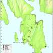
NGR NS 06564 59896
Datum OSGB36 - NGR
Permalink http://canmore.org.uk/site/40234


- Council Argyll And Bute
- Parish North Bute
- Former Region Strathclyde
- Former District Argyll And Bute
- Former County Buteshire
NS05NE 12 06564 59896.
See also NS05NE 11.
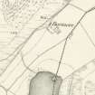
(NS 0656 5988) Lake Dwelling (NR) (Site of)
OS 6" map, (1957)
There is a conical pile of stones, like a cairn, 9 to 10 feet in diameter at water level, which is there 5ft deep, in the north end of Loch Quien.
J Mackinlay 1862.
Field Visit (1863)
Desk Based Assessment (12 August 1972)
There is a conical pile of stones, like a cairn, 9 to 10 feet in diameter at water level, which is there 5ft deep, in the north end of Loch Quien.
Field Visit (11 November 1976)
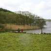
At the published site is a level tree-covered island apparently composed mainly of large stones and measuring 15 metres in diameter and 0.5 metres in height. There is no trace of a causeway nor of any other artificial work.
Visited by OS (B S) 11 November 1976.
Underwater Archaeology (2003)
NS 0656 5988 The crannogs in Loch Quien were surveyed in October 2003. The crannog close to the N shore of the loch consists of a boulder mound measuring 30m N-S by 35m, and over 2m vertically from base to tip; the site should now be confidently identified as a crannog. The mound is ovoid, with the long axis oriented NNE-SSW, while the dry area is roughly circular, with a diameter of 20m. This area of the site is covered by alder trees and grasses. The submerged area of the site, accounting for 75% of the mound, is composed of large boulders, up to 1.5m but averaging 0.5m in diameter. The upper stone of a rotary quern was found on the surface of the site beneath the water level, at NS 06557 59888.
Sponsor: Dr J N Marshall (Isle of Bute) Memorial Trust.
M G Cavers 2003.
Field Visit (7 May 2009)
NS05NE 12 06564 59896
This reed- and alder-grown crannog is as described by Cavers (2003).
Visited by RCAHMS (AGCH) 7 May 2009.

