
Arran, Drumadoon, The Doon


Fort (Prehistoric), Unidentified Pottery (Prehistoric)
Site Name Arran, Drumadoon, The Doon
Classification Fort (Prehistoric), Unidentified Pottery (Prehistoric)
Canmore ID 39199
Site Number NR82NE 1
NGR NR 8860 2925
Datum OSGB36 - NGR
Permalink http://canmore.org.uk/site/39199


- Council North Ayrshire
- Parish Kilmory
- Former Region Strathclyde
- Former District Cunninghame
- Former County Buteshire
NR82NE 1 8860 2925.
(NR 8860 2925) The Doon (Fort) (NR)
OS 6" map, Buteshire, 2nd ed., (1924)
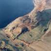
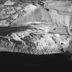
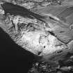
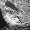
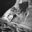
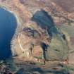
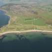
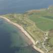
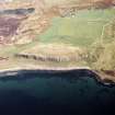
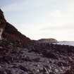
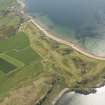
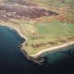
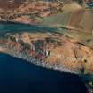
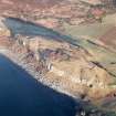
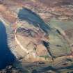
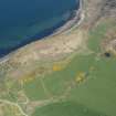
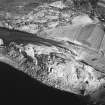
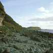
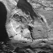
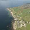
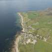
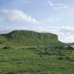
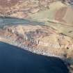
The Doon occupies a commanding position on a headland, Drumadoon Point. The impressive cliffs on the seaward (W) side give sufficient protection there, but on the landward side a single wall, about 10ft thick originally, encloses the entire summit, an area of nearly 12 acres, about 414.5m in greatest length and about 170.0m in greatest width. This wall is greatly denuded, but the entrance is recognisable on the E side. Headrick, in 1807, refers to ruins of houses of loose stone, but none seems to be visible today. Forts of this size, surrounded by a single wall, occur only sporadically in coastlands of W Scotland, and may have formed local tribal centres or "oppida". (Martin {1934} notes "of old it was a sanctuary".)
J N G Ritchie (ed.) 1973; R McLellan 1970; J A Balfour 1910; J Headrick 1807; M Martin 1934.
A fort generally as described above.
There is no trace of the ruins of houses noted by Headrick (1807). On the eastern side of the fort however is a near level natural terrace, sheltered by a steep rocky slope and bounded on the east by the enclosing wall. There are several indistinct scoops at the foot of this rocky slope and while they probably indicate occupation sites there are no surveyable remains. The name "The Doon" was not confirmed locally.
Surveyed at 1:10 000.
Visited by OS (BS) 14 October 1977.
Note (28 October 2014 - 23 September 2016)
This large fort, the largest on Arran, occupies a low hill backing onto the cliffs of the coastal escarpment on the W, and elsewhere flanked by steep grassy slopes. The defences comprise a single rampart, largely reduced to a grass-grown bank up to 5m in thickness by 1m in height, from which large stones protrude through the turf. On the occasion of a visit in August 2009 (SH), a cut through the rampart by fencing contractors on the N side of the entrance midway along the E side revealed that it is composed of earth and stones, and probably roughly faced; six sherds of Grooved Ware were recovered from beneath it. The rampart follows the margins of the hill to create an irregular shape on plan, and the interior measures 390m from NNE to SSW by a maximum of 165m transversely (4.57ha). The only feature visible within it is an upright stone some 1.8m broad by 0.3m thick and 1.5m high.
Information from An Atlas of Hillforts of Great Britain and Ireland – 23 September 2016. Atlas of Hillforts SC2450
Note (24 June 2019 - 25 June 2019)
The location, classification and period of this site have been reviewed.
HES Survey and Recording 24-25 June 2019

