
Barnluasgan


Enclosure (Prehistoric)
Site Name Barnluasgan
Classification Enclosure (Prehistoric)
Canmore ID 39192
Site Number NR79SE 5
NGR NR 79095 91622
NGR Description Centre
Datum OSGB36 - NGR
Permalink http://canmore.org.uk/site/39192


- Council Argyll And Bute
- Parish North Knapdale
- Former Region Strathclyde
- Former District Argyll And Bute
- Former County Argyll
NR79SE 5 7908 9161.
(NR 7908 9161) Circle (NR)
Enclosure, 54' in diameter; several stones c.2' high, set on edge, mark the periphery; one boulder, 4'4" high, set on end, probably marks the entrance. The site is hidden in bracken.
J H Craw 1930.
Now under Forestry Commission plantation; not visited.
M Campbell and M Sandeman 1964.
A poorly-preserved homestead similarly sited to others along the same ridge (NR79SE 3 and NR79SE 4 ) but larger. It measures about 17.0m in diameter over a double-faced wall 2.1m-2.5m wide. The wall is best preserved on the W and consists of vertical slabs with a rubble core. On the N, afforestation makes identification difficult and the wall is fragmentary. No definite entrance is visible, and the interior is featureless.
Surveyed at 1:10 000.
Visited by OS (DWR) 22 May 1973.
This homestead has been almost entirely destroyed by afforestation and although several random boulders are visible, there is now no identifiable structure.
Visited by OS (TRG) 26 January 1977.
NR 79087 91615 Site included in a field survey carried out by GUARD in 2003.
This is a circular enclosure of a east facing slope with an internal diameter of 15.7m. It has a low grass covered bank with upright stones appearing in the south-west and north-west sides.
Heather F James, 2003 (RCAHMS MS 2371, no.95)
Field Visit (May 1984)
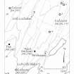
NR 790 916
An enclosure which has been severely damaged by forestry planting lies on a ridge about 500m NNE of Barnluasgan and 470m SW of NR79SE 4; evidently similar in character to the above (NR79SE 121; NR79SE 118; NR79SE 4), it measures about 17m in diameter, and the position of the entrance is not clear.
Visited May 1984
RCAHMS 1988 No. 331 (4)
Note (27 May 2020)
The location, classification and period of this site have been reviewed.

