
Barnluasgan


Dun (Prehistoric)(Possible), Enclosure (Prehistoric)(Possible)
Site Name Barnluasgan
Classification Dun (Prehistoric)(Possible), Enclosure (Prehistoric)(Possible)
Canmore ID 39191
Site Number NR79SE 4
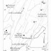
NGR NR 79312 92025
NGR Description Centre
Datum OSGB36 - NGR
Permalink http://canmore.org.uk/site/39191


- Council Argyll And Bute
- Parish North Knapdale
- Former Region Strathclyde
- Former District Argyll And Bute
- Former County Argyll
NR79SE 4 7930 9202.
(NR 7930 9199) Circle (NR)
OS 6" map, Argyllshire, 2nd ed., (1924)
Enclosure, 45' in diameter. Most of the large enclosing stones are set on edge, but a few are upright. To these have been added many smaller stones, making an enclosing mound 3'6" in breadth. The original entrance is not clearly traceable; the interior has been levelled by excavation at the N side.
J H Craw 1930.
A generally well-preserved homestead-type enclosure similar in size and situation to the homestead 285.0m to the NE on the same ridge
(NR79SE 3). Its wall construction is more sophisticated, however, and consists of a double facing of vertical slabs with a rubble core. The entrance on the SW is indicated by a transverse slab on the E side and is about 1.0m wide.
Surveyed at 1:10,000.
Visited by OS (DWR) 23 May 1973.
This homestead is generally as described in the report of 23 May 1973. There is evidence of cultivation on several terraces to the NE.
Surveyed at 1/10,000.
Visited by OS (TRG) 26 January 1977.
NR 79320 92011 Site included in a field survey carried out by GUARD in 2003. This circular enclosure has an internal diameter of 13m. There are upright stones, up to 0.65m high on the north and west sides with a possible bank continuing the enclosure. There is no evidence of an entrance.
Heather F James, 2003 (RCAHMS MS 2371, no.96)
Field Visit (May 1984)
NR 793920
This enclosure is situated in a slight hollow on the summit of a ridge 270m SSW of NR79SE 3 and NR79SE 970 m NNE of Barnluasgan. A low bank of roughly-set boulders encloses an area of about 11m in diameter, levelled into the slope on the NNE. The entrance may have been situated on the SW, where there is a narrow break in the walling; on the W side of the entrance there is a possible rough-out for a quernstone. Traces of 'lazy-bed' cultivation occupy the interior, and a rectangular stone structure measuring 1.63m by 1.45m internally lies about 35m to the S.
Visited May 1984
RCAHMS 1988 No. 331 (3)
Field Visit (1 March 2019)
The location, classification and period of this site have been reviewed.

