
Cove, St Columba's Chapel


Chapel (13th Century), Masons Mark (Medieval)
Site Name Cove, St Columba's Chapel
Classification Chapel (13th Century), Masons Mark (Medieval)
Alternative Name(s) Loch Caolisport
Canmore ID 39011
Site Number NR77NE 1
NGR NR 75135 76759
Datum OSGB36 - NGR
Permalink http://canmore.org.uk/site/39011


- Council Argyll And Bute
- Parish South Knapdale
- Former Region Strathclyde
- Former District Argyll And Bute
- Former County Argyll
NR77NE 1 75135 76759
(NR 7512 7676) Chapel (NR) (Ruins)
OS 6" map, Aberdeenshire, 2nd ed., (1924)
This ruined chapel measures 36' x 17' within 2'4" thick walls. An altar-base of large flags, with traces of cement, has been cleared at the E end, and the floor near is paved; at the W, the floor is cobbled. The bases of sandstone mouldings have been found at the S door; a gap in the wall opposite at N has a large flagstone, apparently a doorstep, possible for access to St Columba's Cave (NR77NE 10). A local tradition suggests that this chapel was dedicated to St John.
M Campbell and M Sandeman 1964.
As described. The dedication could not be confirmed.
Visited by OS (IA) 18 June 1973.
NR 7513 7676. No change to the previous reports.
Surveyed at 1/10,000.
Visited by OS (BS) 27 January 1977.
Measured Survey (1983)
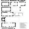
RCAHMS surveyed St Columba's Chapel, Cove in 1983 at a scale of 1:100. The plan was redrawn in ink and published at a scale of 1:250 (RCAHMS 1992, 200A). The plan was also included in an illustration of comparative plans of medieval churches and chapels published at a scale of 1:250 (RCAHMS 1992, 11E).
Field Visit (June 1985)
Two caves penetrate the base of an old sea-cliff l00m N of the shore of Bagh Dalach Duibhe, an inlet of Loch Caolisport which is sheltered by Eilean na h-Uamhaidh ('Island of the Caves'). Excavations in the larger or E cave have found evidence of repeated occupation, including ecclesiastical use in the Early Christian and medieval periods. The ruin of a 13th-century chapel stands some 35m S of the cave, and in the late medieval period it was probably served by the chaplain or hermit who also ministered at Eilean Mor (No.33). The lands of 'Sanct-Colme-coir (St Columba's cave) were associated with Eilean Mor in a charter of 1574 toDonald MacNeill of Taynish, and the township of Cove remained in MacNeill ownership until the middle of the 19th century (en.1).
CHAPEL. The chapel measures 10.9m from E to W by 5.2m transversely within 0.8m walls of lime-mortared rubble slabs and boulders disposed in frequent regular courses. The walls are now fragmentary, and the external facework has been robbed from the S wall, but the W gable survives almostintact. Although the dressed stonework of the quoins andopenings was removed in the 19th century (en.2), the circular bases of the S doorway, carved from a buff Carboniferous sandstone, remain in situ. These display a water-holding-profile of 13th-century character and are socketed for nook-shafts, and the W base preserves a mason's mark. A gap in the N wall may mark the position of a second doorway, but this is uncertain. The chancel, which was lit by an E window and opposed openings towards the E ends of the side-walls, retains a roughly-paved floor with a loose setting of stones marking the position of the altar.
The area W of the chapel is partially enclosed by a curving drystone wall, but is much overgrown and disturbed by later field-drainage. The vertical slabs in a supposed burial ground on the rocky ridge W of the nearby stream, about 60m W of the chapel, appear to be of natural origin, but several inhumations have been excavated near the entrance to the cave (infra).
CAVE. The two natural caves occupy the head of a gully in cliffs of contorted chlorite-schist. The larger one measures about 14m from SW to NE, tapering in width from about 12mto 4.5m, and has a maximum height of about 5m; an inner cave, extending a further 6m to the NE and floored at a lower level, may not have been accessible during the medieval period.
The SE half of the main cave is occupied by a level shelf of rock, probably improved artificially, on which stands an altar of rubble pointed with lime-mortar. An area of the wall above the altar has been cut away to leave in low relief a Latin cross 0.l7m in height and 0.l4m across the arms. Its frame encroaches on an earlier equal-armed cross, much weathered and now represented only by four circular depressions at the terminals (en.4). At the SW angle of the rock-shelf there is an oval basin 0.3m deep, which shows no evidence of having been used as a mortar. A shallower basin near the mouth of the cave may, if of artificial origin, have been designed as a water-catchment for drips from the roof.
Two massive blocks of fallen rock fill the E side of the cave mouth, forming a high ledge which appears to have been reached by steps from both the exterior and the interior, and preserves remains of a transverse drystone wall. This was probably on the same alignment as the wall across the mouth of the cave, described by White as less than 1m high, but shown in a drawing of 1833 by James Skene as containing a lintelled doorway (en.5). Sockets cut in the W wall of the cave in this area may have held strengthening timbers for this wall, but others in the cave are probably related to its use for drying fishing-nets during the 19th century.
The floor of the W half of the cave, formed of accumulated soil almost to the same height as the rock-shelf, was cleared in the 1870s and dumped in a spoil-tip outside the cave. In a series of excavations between 1959 and 1976 this material was examined and replaced in the cave, under the direction of Miss Campbell of Kilberry and Dr C J Young. Finds from this unstratified spoil ranged from prehistoric bone and antler tools, and a rim-sherd of Samian ware, to a folding balance-beam of Norse or medieval date, late medieval coins and 19th-century clay pipes (en.6). The spoil-tip overlay remains of probable metal-working, an E-W drystone wall with entrance, and rough cobbling of probable late-medieval date. Several extended inhumation-burials have been identified, both within the cave and immediately outside it (en.7A) second smaller cave immediately to the W shows no clear evidence of early use.
RCAHMS 1992, visited June 1985

