
Islay, Lagavulin, Barr An T-seann Duine


Fort (Period Unknown)
Site Name Islay, Lagavulin, Barr An T-seann Duine
Classification Fort (Period Unknown)
Canmore ID 38001
Site Number NR44NW 23
NGR NR 40170 45340
Datum OSGB36 - NGR
Permalink http://canmore.org.uk/site/38001


- Council Argyll And Bute
- Parish Kildalton And Oa
- Former Region Strathclyde
- Former District Argyll And Bute
- Former County Argyll
NR44NW 23 4017 4534.
(NR 4017 4534) Barr an t-Seann Duine, a steep-sided headland, has its N, landward, end almost insulated by two steep opposed gullies, each closed by at least two lines of defensive walling. The dry peninsula thus formed is fully occupied by a circular foundation 27ft to 36ft across within a 6 1/2ft wide wall entered from the S. On the greater headland, facing the first structure is a complex comprising a circular foundation 24ft to 37ft across within a 7 1/2ft wall, and on the NE, a semi-circular annexed enclosure 20ft to 23ft across within a 5ft to 6ft wide wall which expands to 12ft in width where it closes with the wall of the circle. The two walls continue towards the N-facing entrance, where the double walling 20ft thick overall acts as a defence along the approach from the E gully.
Further traces of definsive walling run round the E edge of the headland. To the W of the double-walled complex is a third circular foundation, about 32ft in diameter, obscured by a more recent cairn.
F Newall 1963.
On Barr an t-Seann Duine, a headland, there are the scant remains of a fort encompassing the rocky heights, measuring some 90.0m E-W by 60.0m. All that remains are four short wall lengths blocking accessible points in the otherwise steep-sided W and N flanks of the headland, and traces of a wall along the S side, evidenced by a small section of coursed outer face in a band of sparse rubble. The most substantial of the walling, on the W, is up to 4.5m wide. The entrance position could not be identified.
Surveyed at 1:2500.
Visited by OS (JM) 28 March 1979.
Field Visit (June 1979)
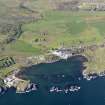
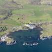
NR 401 453. This fort occupies the summit of the irregular rocky promontory that forms the w side of Lagavulin Bay. Except on the landward (NW) side, where there is easy approach across level ground, the site is protected by cliffs, up to 6m high, falling to the shore and pierced at various points by sharp gullies. The fort wall was drawn around the edge of the summit to enclose an area measuring about 92m by 55m. It survives for the most part as an intermittent spread of rubble core, about 2m broad, with stretches of outer facing-stones standing one course high. The few individual stones of the inner face that are visible indicate that the wall was probably at least 2.5m thick. The gullies are blocked by lengths of walling, the best-preserved of which lies on the NE. It is formed of five carefully constructed courses composed of large irregular blocks with much use of pinning, and stands 1.1m in height; the amount of tumble lying outside the line of the wall suggests that the original height may have been considerably greater. In other gullies the blocking appears to have been achieved by the placing of very large irregular boulders across the gap. The most complex area of walling is situated on the landward side; here the outer and the inner faces of the wall were constructed to link two tall rock outcrops, incorporating a narrow rock spine and giving a wall thickness at this point of about 4m. An intermediate face was also built within the thickness of the wall to provide additional stability. The entrance (a on RCAHMS plan) probably lay on the N side of the fort at one end of a gully.
The interior of the fort is uneven, with areas of grass and numerous irregular rock outcrops; the highest point (20m OD) is marked by a modern cairn (b on RCAHMS plan). To the N of it there are traces of a subcircular structure, now severely robbed, and of a rough stone wall and cultivation plots, all of them probably of no great age. A modern sheep-wall has been constructed below the site of the presumed entrance, and on the NE side of the promontory there are several boat-landings.
RCAHMS 1984, visited June 1979
Measured Survey (1979)
RCAHMS surveyed this fort using plane-table and alidade at a scale of 1:400. The resultant plan was redrawn in ink and published at a reduced scale (RCAHMS 1984, fig. 77).
Note (3 October 2014 - 23 May 2016)
This fort occupies the rocky headland on the W side of Lagavulin Bay. Irregular on plan, the wall is best preserved where it blocks the deep gullies that pierce the outcrops, probably originally measuring about 2.5m in thickness, and in one gully on the NE still standing 1.1m high in five courses with pinnings. In another gully on the NW it is rather thicker and there is also evidence of a medial wall-face within the thickness of the wall. The interior measures up to 92m from E to W by 55m transversely (0.37ha), and the entrance is probably in a gully on the N. Apart from the marker cairn on the summit, there are traces of later cultivation plots and lengths of wall within the interior, but there is also a robbed circular structure measuring some 12m in internal diameter.
Information from An Atlas of Hillforts of Great Britain and Ireland – 23 May 2016. Atlas of Hillforts SC2168
Project (8 August 2018 - 9 August 2018)
NR 4017 4534 Electrical resistance and magnetic gradiometry surveys were carried out, 8–9 August 2018, at the site of the promontory fort of Barr an t-Seann Duine, situated at the W side of the Lagavulin Bay and directly opposite Dunyvaig Castle. The fort is being investigated as part of the Dunyvaig and Hinterland Assessment Project. The space on the summit of the fort is uneven and interspersed with bedrock outcrops, thus only some parts of the site are suitable for geophysics. The 2018 survey covered a grassy level area at the E side of the fort where a circular depression is suggestive of a possible structure. Electrical resistance survey was conducted using a RM15 Geoscan resistance meter with twin probe configuration, 0.5m traverse spacing and 1m interval readings. Magnetic gradiometry was carried out with a Bartington Grad601 instrument with 0.5m traverse spacing and 0.25m reading intervals. Both magnetic and electrical resistance survey suggest a possibility of one or more sub-circular structures at this part of the fort.
Report and archive: NRHE and WoSAS
Funder: Islay Heritage and University of Reading
Darko Maričević, Robert Fry, Thomas King and Steven Mithen –
Islay Heritage and the University of Reading
(Source: DES, Volume 19)
Resistivity (8 August 2018 - 9 August 2018)
NR 4017 4534 Resistivity survey.
Report and archive: NRHE and WoSAS
Funder: Islay Heritage and University of Reading
Darko Maričević, Robert Fry, Thomas King and Steven Mithen –
Islay Heritage and the University of Reading
(Source: DES, Volume 19)
Magnetometry (8 August 2018 - 9 August 2018)
NR 4017 4534 Magnetometry survey.
Report and archive: NRHE and WoSAS
Funder: Islay Heritage and University of Reading
Darko Maričević, Robert Fry, Thomas King and Steven Mithen –
Islay Heritage and the University of Reading
(Source: DES, Volume 19)

