
Colonsay, Loch An Sgoltaire


Artillery Fortification (17th Century), Castle (Medieval)(Possible), Summerhouse (19th Century)
Site Name Colonsay, Loch An Sgoltaire
Classification Artillery Fortification (17th Century), Castle (Medieval)(Possible), Summerhouse (19th Century)
Canmore ID 37868
Site Number NR39NE 5
NGR NR 3868 9723
Datum OSGB36 - NGR
Permalink http://canmore.org.uk/site/37868


- Council Argyll And Bute
- Parish Colonsay And Oronsay
- Former Region Strathclyde
- Former District Argyll And Bute
- Former County Argyll
NR39NE 5 3868 9723.
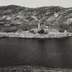
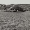
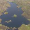
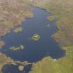
(NR 3867 9722) The remains of a 'fort' with inner and outer works about 15 and 30 paces square with round towers at the corners lies on an island in Loch an Sgoltaire. Its origins are not known, but it was re-fortified in 1615 and again used as a place of refuge in 1701. A summer-house was built on the site in the 19th century. The situation and the use of round towers with a wall of enclosure suggest a 13th century castle comparable with Lochindorb (NH93NE 1), but the actual enceinte in this case would appear to be very small.
A narrow causeway is said to lead from the island to the shore, but since the raising of the level of the loch in the 20th century, it is not identifiable.
S Grieve 1923; J de V Loder 1935
NR 3868 9723: The remains of a castle consisting of a sub-square keep and outer curtain wall. The keep walls are 8.0m x 10.0m long internally, up to 2.5m thick and 1.4m high. Round bastions occupy each corner and a stairway gives access to the wall head within the NE bastion. The gateway and much of the walling is of 19th century reconstruction. The curtain wall measures up to 2.0m wide and 1.0m high, and has three bastions. Its entrance on the N is occupied by a 19th century arch. A rectangular enclosure on the S side of the island is of recent date.
Although conforming to an early plan, much of the castle appears to have been rebuilt in the 19th century including the archway through the outer wall and the gateway into the keep.
Surveyed at 1:10,000.
Visited by OS (DWR) 16 April 1974
Field Visit (April 1978)
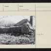
NR 386 972. This early 17th-century artillery fortification stands upon the largest of a group of islands in Loch an Sgoltaire, a stretch of water that is surrounded by low hills and lies within easy reach of the NW coast of Colonsay at Uragaig. The surviving remains of the fort were modified and added to during the course of the 19th century when the island was used as a retreat by the owners of nearby Colonsay House, the most obvious result of this activity having been the erection of a small summer-house or arbour within the inner enclosure.
The layout of the fortification in its existing form can best be appreciated by reference to the accompanying plan. (See RCAHMS Inventory plan, 1984). It consists of a roughly concentric system of defence incorporating outer and inner thick-walled curtains. The outer enceinte is a pentagonal enclosure measuring 33m in maximum extent from E to W by over 30m from N to S. There are remains of roughly circular drum-bastions at all except the W salient, and a pair of partly rebuilt towers of this kind flank a round-arched entrance-gateway in the N sector. These reconstructed portions of walling exhibit traces of later lim mortar and lime pointing, but they are otherwise of drystone rubble construction with a pronounced batter on both faces of the curtain. The wall measures about 2m in average thickness at base, and the well-preserved NW and SW lengths of curtain survive to an external height of about 1.25m. The bastions vary between 4m and 5.5m in diameter, while the SE bastion, which has undergone later reconstruction, is of an elongated elliptical plan.
The N gateway and the E circuit of this outer enclosure skirt the water's edge, whilst the remainder of the island is circumscribed by a low stone kerb. Outside the fortified enclosure in the s half of the island there are vestiges of a rectangular walled enclosure incorporating an oblong sunken pit in the SE angle; the enclosure measures 11m in ascertainable length from N to S by 9m transversely within walls 0.6m in thickness.
The inner enceinte is a compact and irregular but approximately square enclosure, measuring about 15m from E to why 14m over opposite faces of the curtain-wall. It incorporates four rounded angle-bastions which are from 4m to 4.5m in diameter. The curtain-wall stands to a maximum external height of 2m along the N front, and is also about 2m in average thickness. A round-arched gateway with stepped approach and crenellated parapet above is located in the centre of the N wall, but much of the entrance and adjacent lengths of lime-pointed walling appear to have been reconstructed in the 19th century. Some of the bastions also possess a reconstructed 0.5m high crenellated parapet, the best-preserved outward-splayed crenelles being on the NW bastion. A narrow intramural stair gives access to the wall-head of the NE bastion, and in the diagonally opposite corner adjacent to the SW bastion there is a small 0.3m square aumbry of uncertain purpose.
The summer-house is a plain single-storeyed and hip-roofed building measuring 5.65m square. The principal or NE frontage has a central doorway with flanking windows and is surmounted by a rounded pediment; the rear or SW wall contains a central fireplace set between a pair of niches.
The site is well suited to the type of island-refuge that evidently prevailed in this region during the later medieval and post-medieval periods, but the surviving remains probably date substantially from the period of Sir James MacDonald's rebellion in 1615. A report of 26 June of that year recorded that upon his arrival on Colonsay a few days earlier Sir James 'maid ane strenth in it upon ane fresch wattir loch in ane eylanne', the design and construction of the fortification being similar to that erected in Loch Gorm, at about the same time.
Visited April 1978
RCAHMS 1984
Measured Survey (1978)
RCAHMS surveyed the fortification on Loch an Sgoltaire in 1978. The plan was redrawn in ink and published at a reduced scale (RCAHMS 1984, fig. 281).

