
Islay, Robolls Hill


Field System(S) (Medieval) - (Post Medieval), Rig And Furrow (Medieval) - (Post Medieval)
Site Name Islay, Robolls Hill
Classification Field System(S) (Medieval) - (Post Medieval), Rig And Furrow (Medieval) - (Post Medieval)
Alternative Name(s) Kepolls
Canmore ID 79761
Site Number NR36NE 70
NGR NR 3895 6695
NGR Description NR 3815 6640 to NR 3945 6812
Datum OSGB36 - NGR
Permalink http://canmore.org.uk/site/79761


- Council Argyll And Bute
- Parish Killarow And Kilmeny
- Former Region Strathclyde
- Former District Argyll And Bute
- Former County Argyll
Field Visit (8 September 1993 - 12 September 1993)
NR36NE 70 3815 6640 to 3945 6812
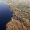
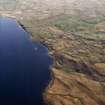
The extensive remains of field-banks and rig-and-furrow cultivation stretch across the W flank of Robolls Hill, from Kepolls Farm in the S to the march dyke between Kepolls and Finlaggan on the N.
The major field-banks run up from the shore of Loch Finlaggan, following the edges of stream gullies, but only in a few instances do they disappear across the crest of the hill. These banks define the overall extent of cultivation on the hill, and enclose a network of lesser banks which divide the area into a series of smaller fields or plots. The state of preservation of the banks varies; at best, they stand to a height of 1m with a stone face; at worst, they have been reduced to little more than a low spread mound or a rickle of stones. The majority have been constructed of stone and turf, sometimes combining a stone face with an earthen core and a turf capping.
Within these plots, a complex pattern of rig-and-furrow cultivation is visible; the multi-phase nature of the field-system is evident not only in the field-banks, but also in the pattern of ridging, and in several places one alignment can be seen to overlie another. Of note is the absence of any farmstead, and the only structures visible are either kilns and small enclosures, or else they are associated with the mining remains. (See NR36NE 35-6, 49.05, 54-6, 59, 63 and 65).
The majority of the field-system is depicted as rough pasture on the 1st edition of the OS 6-inch map, suggesting that the cultivated fields had been long abandoned by this date (Island of Islay, Argyllshire, Sheet cxcviii, 1882).
Visited by RCAHMS (ARW/SPH/PC) 8-12 September 1993.

