
Islay, Carraig Fhada


Clearance Cairn(S) (Period Unassigned)
Site Name Islay, Carraig Fhada
Classification Clearance Cairn(S) (Period Unassigned)
Canmore ID 37636
Site Number NR34SW 3
NGR NR 3466 4428
Datum OSGB36 - NGR
Permalink http://canmore.org.uk/site/37636


- Council Argyll And Bute
- Parish Kildalton And Oa
- Former Region Strathclyde
- Former District Argyll And Bute
- Former County Argyll
NR34SW 3 3466 4428.
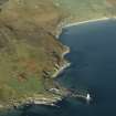
NR 374 443. Among the numerous heaps of stones above Port Ellen lighthouse is one, forming a sacucer-like ring about 66ft by 26ft. This may have been an open burial.
W Lamont 1959; F Celonia 1959.
NR 3466 4428. A mound of cleared stones built around a rock outcrop and measuring 22.0m by 11.0m. It is situated within an area of ruined walls and other mounds of cleared stones. All of these remains are associated with the ruined farm 150.0m to the north east and are of no great age.
Visited by OS (BS) 3 June 1978.

