
Islay, Alt Nan Ba


Building(S) (Period Unassigned), Fort (Period Unassigned), Structure(S) (Period Unassigned)
Site Name Islay, Alt Nan Ba
Classification Building(S) (Period Unassigned), Fort (Period Unassigned), Structure(S) (Period Unassigned)
Canmore ID 37513
Site Number NR27SW 13
NGR NR 2185 7115
NGR Description NR 2185 7115 and NR 2192 7115
Datum OSGB36 - NGR
Permalink http://canmore.org.uk/site/37513


- Council Argyll And Bute
- Parish Kilchoman
- Former Region Strathclyde
- Former District Argyll And Bute
- Former County Argyll
NR27SW 13 2185 7115 and 2192 7115
(NR 2185 7115 and NR 2192 7115) Fort, 'Beehive' huts and enclosures.
Information from RCAHMS to OS.
At NR 2185 7115 across the neck of a low peninsula in a natural ampitheatre bounded by cliffs up to 45m high is a dry-stone wall of massive proportions effectively defending the peninsula. The wall is generally well-preserved 2.0m to 2.5m wide and at best surviving to a height of 1.2m. At the easiest point of access, tumbled stone has been cleared from the wall revealing an external recess 1.7m deep into the wall. No entrance passage can be identified. The area of the peninsula enclosed by the wall contains no visible structures.
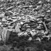
Extending southwards for about 30.0m and ending at the base of a cliff is a further wall of uncertain date and purpose. Abutting it are three contiguous circular structures varying from 1.0m to 1.9m internal diameter and surviving to 0.8m in height.
At NR 2192 7115, contiguous, but across a gulley and straddling a natural terrace blocking access along it, are the tumbled remains of a dry-stone wall of massive proportions. It closes at the base of a cliff on the E side and extends westwards towards the rocky inlet for at least 30.0m. Where best preserved towards the E end, it s 2.5m wide, and survives to a maximum height of 2.2m; it contains an entrance (no door checks), 0.8m wide and 1.0m high, which is roofed by stone lintels some of which remain in situ. Built against the N face are two roughly-rectangular dry-stone structures; the larger, 5.5m by 3.0m may be contemporary, but the smaller, 2.5m by 1.5m, blocks the entrance, and is considered to be fairly recent. The proportions and construction of the wall are "dun-like", but it is so well-preserved that its origins are probably more recent. Its purpose cannot be determined.
To the N of this wall on rocky uneven ground between the sea and the base of the cliff is a well-preserved and fully roofed beehive cell, the footings of one or two more possible examples, and some apparent scoops in the ground indicating former occupation, but at what period and whether contemporary with the isolating wall remains uncertain.
Although the form of the walls isolating both peninsulas is typical of forts, the mode of construction is extremely crude, and the position below the cliffs, though a reasonable defence, is unusual.
A promontory fort (NR27SW 5) overlooks from a height of about 35m OD. It is suggested that both contiguous sites represents a monastic settlement in typical isolation, virtually invisible from the land and inaccessible by sea, though no evidence exists in the form of place-names or local tradition to confirm this.
Surveyed at 1:10 000.
Visited by OS (N K B) 28 June 1978.
Field Visit (May 1979)
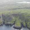
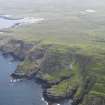
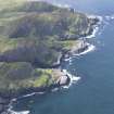
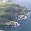
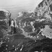
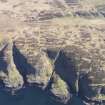
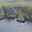
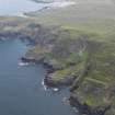
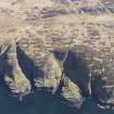
Beinn a' Chaisteil is the name given to a prominent rocky headland which forms part of the rugged NW coastline of Islay w of Sanaigmore; rising to a height of 125m OD, it presents sheer cliffs to the NW and NE, but from the SE (landward) side there is relatively easy access up grassy or heathery slopes interspersed with rocky outcrops. Extending between it and Cnoc Uarnh narn Fear (128m OD) to the SW there is a broad, steep-sided, natural hollow, which is divided by a narrow inlet, Allt nam Ba. Situated on Beinn a' Chaisteil and in the gully below there is an unusual complex of remains, comprising what appear to be three elements that are not necessarily related to each other: a fort (A on the site-plan, RCAHMS 1984) occupying the summit of Beinn a' Chaisteil; settlement (B), lying around the foot of Beinn a' Chaisteil to the E of Allt nann Ba; and an enclosure (C), situated in a low-lying position on the neck of a rocky promontory W of Allt nam Ba.
FORT (NM 220 711). The defences are provided by a single stone wall drawn across the neck of the headland and cutting off a roughly triangular area of about 1.35ha. For most of its length the wall survives as a band of rubble core material with intermittent stretches of outer facing-stones still standing to a height of 0.4m in three courses; only one short length of inner face survives, near the sw end, indicating that at this point the wall was 3m thick. For almost its entire course the wall is founded on the natural rock, and several expanses of outcrop are incorporated within its structure. About half-way along its length it swerves sharply outwards to follow a particularly prominent outcrop, perhaps in order to provide extra defensive strength for what may be the position of an entrance (a on the RCAHMS plan), where the rubble is markedly thinner and where there is easy access from outside. At each end the wall terminates on the brink of the cliff, but on the SW, where it finishes in a coursed butt-end, access to the interior can be gained with little difficulty by way of two rocky ledges beyond and below it. No visible evidence remains of walling to block this line of approach, but without it the defensive effect of the rest of the wall would have been severely impaired; it could, however, have been easily dismantled and cast down the steep slope without trace, possibly for use in building the structures described below.
In addition to the possible entrance (a on RCAHMS plan) already mentioned a narrow transverse gap in the outcrop about 30m to the would have provided another suitable entry; between these two points there are traces of a medial face within the thickness of the wall. A third possible location for an entrance (b on RCAHMS plan) occurs towards the SW end, where the amount of debris is noticeably reduced. The interior, which is thickly covered with heather, shows no visible signs of structures.
SETTLEMENT (NM 219 711). The landward approach and part of the precipitous slopes on the E side of the Allt nam Ba are traversed by the remains of a massive drystone wall which is some 2m in average thickness and about 60m in surviving length from E tow. It incorporates a lintelled entrance passage (a on RCAHMS plan) which is slightly less than 2m in length and 0.75m in width; it is entered from the s where there are traces of low stone platform. At the rear of the wall there are surviving remains of two adjacent round-ended enclosures, and a possible hut-platform (b on RCAHMS plan) lies close to the rock-face that marks the E boundary of the site. Lower down the slopes of the E side of the inlet there is a second group of structures comprising traces of at least three buildings of circular plan. The largest and best-preserved of these (c on RCAHMS plan) measures over 4m in internal diameter within walls 0.5m in thickness, and has an entrance 0.6m wide in the S sector. There are no superficial indications of man-made structures on the grass plateau immediately to the E of the inlet, and a third main group of buildings and enclosures is found at the foot of the scree slopes in the rocky area to the NE. One hut survives (d on RCAHMS plan [NR 2194 7126]), relatively intact and has a slab-corbelled roof. It is of ovoid plan measuring 2.5m in length by 1.1m in width and 1.3m in height internally; the entrance is located in the S end-wall.
ENCLOSURE (NM 218 712) [Canmore ID 37513]. A massive drystone wall follows the line of a ridge across the promontory to the W of Allt nam Ba. It extends in an eastward direction for a distance of about 50m, and there is a further stretch of walling which straddles a gully to the NW. The wall, which measures over 2m in average thickness and stands to a maximum height of 1.3m, incorporates the foundations of what appear to be small intramural chambers of oblong plan entered externally from the S or W rather than from seaward. The best-defined specimen (e on RCAHMS plan) measures 1.6m in length by 0.6m transversely. It is also possible that one of these features may represent a modification to an original entrance comparable with that located in the stretch of walling on the NW. A later dyke extends southwards from this main E-W wall and is associated with a circular hut and enclosure in the centre of a narrow defile. There are indeterminate vestiges of other structures among the rocks to the W and on the hillside to the sw. A small burn which flows down the main gully from the SW is the only obvious source of fresh water in this vicinity.
The date and original purpose of the enclosure and settlement cannot be determined without excavation, but it is possible that both were associated, at least in their later phases, with grazing or sea fowling.
RCAHMS 1984, visited May 1979
Measured Survey (1979)
RCAHMS surveyed the fort, settlement and enclosure at Beinn a' Chaisteil in 1979.
The surveys included:
(i) a 1:2500 location map
(ii) a 1:400 plan of the eastern fort (A)
(iii) a 1:400 plan of the western fort (C) (called an enclosure by RCAHMS) and the intervening settlement (B)
(iv) a plan, section and elevation of a small corbelled building (d) within the settlement
The plans were redrawn in ink and published at reduced scales (RCAHMS 1984, figs. 78A, 78C, 79 and 90).
Note (29 September 2014 - 23 May 2016)
A precipitous promontory projecting from the foot of the coastal cliffs on the NW coast of Islay is cut off by a wall 2m in thickness and still standing 1.3m high. Several rectangular chambers are built into the wall, but these may be later adaptations, one possibly exploiting an original entrance. The promontory beyond the wall measures about 175m from NW to SE by 115m transversely (1.36ha). A wall also drops down the slope on the S to a small hut and pen, but these, together with several other structures amongst the boulders to the W, are probably related to much later use.
Information from An Atlas of Hillforts of Great Britain and Ireland – 23 May 2016. Atlas of Hillforts SC2120

