
Scheduled Maintenance
Please be advised that this website will undergo scheduled maintenance on the following dates: •
Tuesday 3rd December 11:00-15:00
During these times, some services may be temporarily unavailable. We apologise for any inconvenience this may cause.
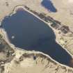
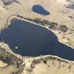
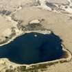
Islay, Loch Langeadail


Building(S) (Medieval) - (Post Medieval), Causeway (Period Unknown), Crannog (Period Unknown), Island Dwelling (Medieval) - (Post Medieval)
Site Name Islay, Loch Langeadail
Classification Building(S) (Medieval) - (Post Medieval), Causeway (Period Unknown), Crannog (Period Unknown), Island Dwelling (Medieval) - (Post Medieval)
Alternative Name(s) Loch Laingeadail
Canmore ID 37493
Site Number NR27SE 27
NGR NR 26609 71274
Datum OSGB36 - NGR
Permalink http://canmore.org.uk/site/37493


- Council Argyll And Bute
- Parish Kilchoman
- Former Region Strathclyde
- Former District Argyll And Bute
- Former County Argyll
NR27SE 27 2660 7127.
At NR 2662 7127, some 30m from the south shore of Loch Laingeadail is a crannog, overgrown with turf and scrub, but apparently composed entirely of rubble stones. It measures 18m in diameter and 1.4m high, bounded by traces of a retaining wall of large stones 0.5m high. In the centre are the footings of a later rectangular building, 6.2m by 3.4m within a wall about 1.3m wide. There are fragmentary remains of a causeway from the shores, but there is a distinct gap of 8m-10m at the end nearest the crannog. The level of the loch is lower now than when the crannog was constructed, and the site is accessible by wading.
Visited by OS (N K B) 18 June 1978.
NR 2660 7127 Located 28m from the S shore of Loch Laingeadail. At the time of survey, the water reached a maximum depth of 1.5m between the site and shore. The artificial islet is a circular, stone-covered mound which measures 26.5m in diameter at its base. The site is composed of 80% medium-sized stone and 20% large boulders, and appears to be entirely artificial. The upper surface of the islet is also circular, measuring 18.5m in diameter, and was heavily overgrown with willow and briars at the time of survey. The outside edge of the upper platform was found to be 0.2m below the water level, with the remainder of the upper platform protruding into the air by only 0.25m.
Sponsors: Edinburgh University Archaeology Department, Holley & Associates.
M W Holley 1996
Field Visit (September 1979)
NR 266 712. This small natural island lies about 30m from the s shore of Loch Laingeadail. It is roughly circular on plan, measuring about 19m in maximum diameter, and stood to a height of about 1.5m above the water-level of the loch at the date of survey. The boulder-strewn perimeter shows that the shape and construction of the island has been artificially improved; the facework of a short stretch of an outer enclosing wall is visible in the W sector where it survives to a height of 0.4m, and in the SE sector the footings of this wall appear to form a short landward spur, possibly marking the site of a former jetty or landing-place adjacent to building A. The remains of this building consist of the foundations of a round-angled rectangular structure measuring 6m in length fropi E to W by 3.5m transversely within drystone walls 1m in average thickness and 0.7m in maximum height. The entrance was possibly in the NE side-wall and there is a broad inner platform within the w angle of the building. Vestigial traces of a second and smaller structure, which is very largely obscured by vegetation, lie closer to the W shore of the island. The visible remains indicate a building of rectangular plan, open-ended to the S, and measuring 4.5m in length by 3m transversely within drystone rubble wall's 1m thick There are fragmentary traces of a rubble causeway extending from the S shore of the loch.
The island has no recorded history, but, by analogy with other structures of this type, the buildings can probably be ascribed to the medieval or early post-medieval period.
Visited September 1979
RCAHMS 1984
Measured Survey (1979)
RCAHMS surveyed the island dwelling at Loch Laingeadail at a scale of 1:200. The plan was redrawn in ink and published at a reduced scale (RCAHMS 1984, fig. 156B).

