
Islay, Rubh' An Duin, An Dun


Dun (Period Unknown)(Possible)
Site Name Islay, Rubh' An Duin, An Dun
Classification Dun (Period Unknown)(Possible)
Alternative Name(s) Loch Indaal Lighthouse
Canmore ID 37306
Site Number NR25NE 3
NGR NR 2570 5881
Datum OSGB36 - NGR
Permalink http://canmore.org.uk/site/37306


- Council Argyll And Bute
- Parish Kilchoman
- Former Region Strathclyde
- Former District Argyll And Bute
- Former County Argyll
NR25NE3 2570 5881
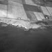
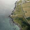
(NR 2570 5881) Lighthouse on site of (NAT) An Dun (NR)
OS 6" map (1900)
For (overlying) Lochindaal Lighthouse, see NR25NE 22.
The site of an ancient fort, known as An Dun, 'on the very foundation' of which the lighthouse is built.
Name Book 1878
There is no trace of any structure at or near this lighthouse (NR25NE 22). The site is generally unsuitable for a dun being low-lying coastal rock, which is easily approached from the landward side and lacks any natural defence. (There is an An Dun further down the coastline at NR 2218 5420 (see NR25SW 3).
Visited by OS (BS) 2 May 1978.
Field Visit (July 1975)
NR 257 588. Nothing can now be seen of the fortified site An Dun, which is reported to have been destroyed when a lighthouse was constructed on the tip of the rocky headland of Rubh' an Duin. In view of the space available for use, it seems likely that the structure was of no great size and probably a dun.
RCAHMS 1984, visited July 1975

