
Islay, Lower Glenastle


Field System (Period Unassigned), Head Dyke (Post Medieval), Kiln (Period Unassigned)(Possible), Rig And Furrow (Medieval) - (Post Medieval), Township (Period Unassigned)
Site Name Islay, Lower Glenastle
Classification Field System (Period Unassigned), Head Dyke (Post Medieval), Kiln (Period Unassigned)(Possible), Rig And Furrow (Medieval) - (Post Medieval), Township (Period Unassigned)
Canmore ID 81685
Site Number NR24NE 14
NGR NR 2890 4570
NGR Description Centred on NR 2890 4570
Datum OSGB36 - NGR
Permalink http://canmore.org.uk/site/81685


- Council Argyll And Bute
- Parish Kildalton And Oa
- Former Region Strathclyde
- Former District Argyll And Bute
- Former County Argyll
NR24NE 14 centred on 2890 4570
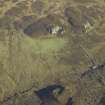
A probable 18/19th century deserted farmstead situated in sheltered hollow on SW facing hillslope. It comprises the ruins of five rectangular buildings some surviving to roof height. There are several field walls visible and evidence of extensive rig-and-furrow cultivation in the vicinity.
Visited by OS (TRG) 29 May 1978
A township comprising seven unroofed buildings, one of which is L-shaped, one unroofed circular structure, which may be a kiln, three enclosures and a head-dyke is depicted on the OS 1st edition 6-inch map (Argyllshire 1882, sheet ccxxxi). A sixth unroofed building lies approximately 300m to the W and is attached to the head-dyke. The head-dyke is shared to the E with that of the the farmstead of Tornabakin (NR24NE 5).
Seven unroofed buildings, two enclosures and the head-dyke are shown on the current edition of the OS 1:10000 map (1981).
Information from RCAHMS (SAH) 4 December 1998

