
Orsay, Chapel


Burial Ground (Medieval), Chapel (Medieval)
Site Name Orsay, Chapel
Classification Burial Ground (Medieval), Chapel (Medieval)
Alternative Name(s) Orsay Island, St Orain's Chapel; St Orans Chapel; St Columba's Chapel; Hugh Mackay's Grave
Canmore ID 37250
Site Number NR15SE 1
NGR NR 16404 51679
Datum OSGB36 - NGR
Permalink http://canmore.org.uk/site/37250


- Council Argyll And Bute
- Parish Kilchoman
- Former Region Strathclyde
- Former District Argyll And Bute
- Former County Argyll
NR15SE 1 16404 51679.
NR15SE 1.1 Carved Stone
NR15SE 1.2 Hugh Mackay's Grave
(NR 1640 5167) Chapel (NR) (In Ruins) (NAT)
OS 6" map (1900)
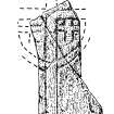
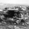
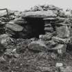
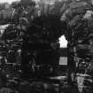
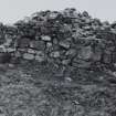
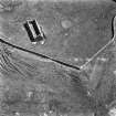
Hugh MacKay's Grave, Tung Mhic Aoidh na Ranna, is a late Medieval tomb at the NE corner of the burial enclosure, at which on Septmeber 5th 1959 Mrs I Ramsay found fragments of a possibly 6th to 8th century cross-slab bearing an incised outline ring-cross with crosslets. It is said that other grave-stones were disposed of in crannies among the adjoining rocks when the lighthouse was built. Chaplains were being presented to the chapel as late as 1556.
OPS 1854; R C Graham 1895; F Celoria 1960; SDD List 1962
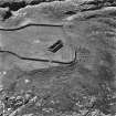
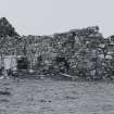
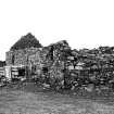
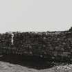
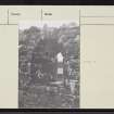
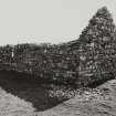
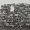
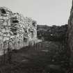
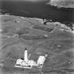
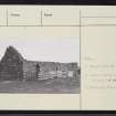
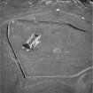
St Orain's Chapel, a simple parallelogram in plan measuring 48ft externally, with features indicating considerable antiquity. It has been enlarged by an eastern extension which comprises rather more than a quarter of the total length. It is unbanded but apparently for the purpose of consolidating the union part of the original gable wall has been left on each side and taken into the thickness of the new wall, so that in the interior there is a resemblance to a chancel. In the older building which is of the First-Pointed Period there are only two windows, a lancet in the N wall, and another along with a pointed doorway in the wall opposite. The W elevation is blank. In the later work all the windows are flat-headed except a lancet in the E gable. The burial ground was cleared for the lighthouse-keeper to use it as a garden but, as nothing would grow in it, it was abandoned and is now a bare paddock.
T S Muir 1855
Field Visit (July 1974)
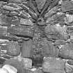
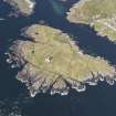
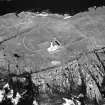
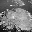
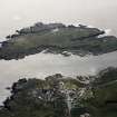
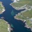
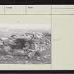
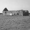
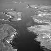
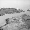
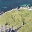
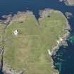
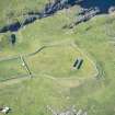
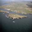
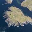
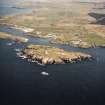
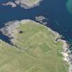
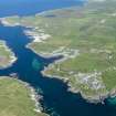
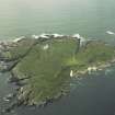
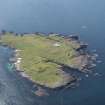
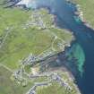
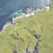
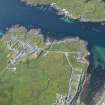
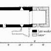
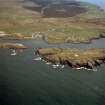
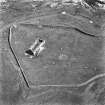
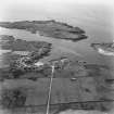
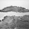
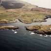
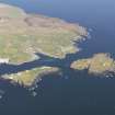
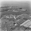
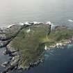
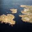
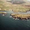
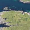
NR 164 516. This medieval chapel stands within a walled enclosure upon a flat-topped promontory at the N end of the island, overlooking the narrow sound that divides Orsay from the Islay mainland. The chapel is now incorporated within an oblong gable-ended building measuring about 13.1m in length from E to W by 3.8m transversely within walls some 0.8m in thickness. The chapel itself, having an internal length of about 8.7m, constitutes the w portion of this building, the remainder of which appears to have been added at a comparatively recent date as part of a scheme to convert the entire structure into a storehouse.
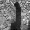
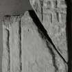
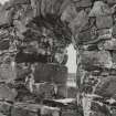
The chapel is constructed of local rubble masonry roughly brought to courses and well bonded with pinnings laid in coarse lime mortar. There is no evidence of the use of freestone dressings. The walls are founded upon an intermittent plinth of boulders and the external wall-surfaces were evidently harled. The doorway, situated towards the W end of the S wall, is a tall arch-pointed opening 0.85m in width equipped neither with bar-hole nor door-checks; its present appearance may owe a good deal to modern reconstruction. The chapel was lit by a pair of directly opposed lancet-windows placed in the side-walls towards the E end of the building. These windows have deeply splayed jambs and heads, the latter being roughly formed with slab voussoirs and shaped keystones. There may originally have been a third window in the E gable, which was almost entirely dismantled when the building was extended in length. The inner face of the w gable is intaken at wall-head-level. The interior of the chapel is now featureless, but it is clear that there was no structural division betwen nave and chancel.
The E extension comprised two storeys, the masonry being of random rubble bonded with pinnings laid in coarse lime mortar. The walls of the lower storey measure about 0.9m in thickness, those of the upper storey being of the same thickness as those of the chapel. There is no external doorway, access to the interior evidently having been obtained via the chanel. Each storey was lit bv a pair of splayed and lintelled windows placed opposite to each other in the side-walls, the upper storey having in addition a window in the E gable, which now lies collapsed. The upper floor was of timber.
Although the building lacks any criterion for close dating, it appears probable that the chapel itself is of late medieval date, a conclusion which gains some support from the documentary evidence cited below, while the E extension may be ascribed to the late 18th or 19th century.
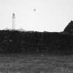
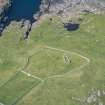
The enclosure, or burial-ground, is of irregular plan, measuring about 80m from N to S by about 66m transversely. The existing wall of enclosure, which incorporates a gateway at the s corner, was evidently erected at about the time of the establishment of the adjacent lighthouse-station (RCAHMS 1984, No. 441). Just outside the present wall, however, there are some traces of its immediate predecessor, which appears to have followed a similar line. This earlier wall is best seen on the NW and SW sides of the promontory, where it appears as a ruinous drystone dyke some 1.25m in width and 0.5 m in height. On the NW side, however, there is some evidence to suggest that this dyke itself stands upon an older wall or rampart of more substantial proportions. Outside the E wall of the enclosure there are a number of plough-rigs, while further possible traces of rigs within the enclosure suggest that much of the former burial-ground was under cultivation before the establishment of the lighthouse station. Apart from Hugh MacKay's Grave (infra) there are no visible traces of burials.
Although local tradition claims Orsay as an early monastic site no corroborative evidence of this identification has so far come to light. The cross-slab described below, however, bears witness to ecclesiastical occupation on the island, probably during the 8th or 9th century. The existing church is probably to be identified with the chapel of an oilen Eorsaigh, which John I, Lord of the Isles, is said to have roofed and furnished before 1380. (information from Mr G Clark, Port Charlotte; Exch Rolls, 1502-7, 1508-13) The local belief that the dedication was to St Columba is confirmed by the record of insula Sancti Columbe de llanorsa in lley ('St Columba's isle of Orsay in Islay') as church land in a Crown rental of 1507. Presentations to the chaplainry by the Crown, as successor to the Lords of the Isles, were recorded in 1535, 1541 and 1556. (Registrum Magni Sigilli Regum Scotorum 1908-) The chapel is mentioned by Dean Monro in 1549 and appears on Pont's map of the late 16th century. The building had evidently fallen into ruin by the end of the 18th century, and when Graham visited the island a century later he was told that 'when the present lighthouse was built on Orsay (1824), the graveyard surrounding this church was levelled, and that the tombstones were disposed of in some of the crannies of the adjoining rocks'. ((Monro 1884 ; Blaeu's Atlas, Islay; Statistical Account 1791-9; Graham 1895)
Carved Stone.
Three fragments of an Early Christian cross-slab, found beside Hugh MacKay's Grave in 1959, (Islay Archaeological Survey Group 1960) are now in the Museum of Islay Life, Port Charlotte. They are of grey hornblende-schist, probably derived from the Lewisian of Islay, and together measure 0.53m in length by 0.27m in maximum width. On one face there was incised a ring-headed outline cross with square armpits, having an outline Greek cross in each of the lower cantons within the ring, the only ones for which evidence survives. In the lower right canton the spaces above the arms of the crosslet are roughly tooled to form pellets, as on a cross-slab from Killean, Kintyre. (RCAHMS 1971)
Whereas bosses or pellets in ringed crosses are of frequent occurrence, and the grouping of crosslets round an unringed cross is found both on altar-slabs and upright slabs, the combination found here is difficult to parallel.(RCAHMS 1984)
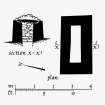
Mortuary House.
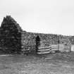
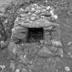
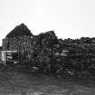
The only monument now visible within the burial-ground is the remarkable tomb known as Hugh MacKay's Grave, which stands near the N corner of the enclosure. This is a well-built structure of rubble masonry laid in clay mortar which incorporates an oblong chamber of unknown depth measuring 1.95m in length and about 0.5m in width. The walls have a thickness of about 0.5m and the chamber is ceiled with slab-lintels covered with small boulders. This tomb, which bears some resemblance to awell-known type of Irish mortuary-house, (Ulster J Archaeol) is probably of medieval date. The family of MacKay of the Rinns for lona served the MacDonalds as lieutenants of that district of Islay. (Proc Royal Irish Academy; Lamont 1968; Steer and Bannerman 1977; MacNeill 1900)
Visited July 1974
RCAHMS 1984
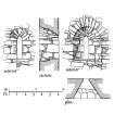
Measured Survey (1974 - 1975)
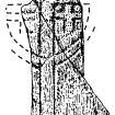
RCAHMS prepared measured survey drawings of Orsay chapel and Hugh Mackay's Grave between 1974 and 1975 including a phased plan of the chapel at 1:100, a general plan of the site at 1:400, details of the S window at 1:20, and a plan and section of the mortuary building at 1:100. The drawings were published at a reduced scale (RCAHMS 1984, figs. 254, 255C, 255D, 256B).
Field Visit (12 May 1978)
The ruins of St Orain's Chapel (name not verified) are generally as described. Orientated E-W it measures 14.8m E-W by 5.3m over walling 0.7m thick. The E gable has tumbled and the rubble lies outside the building. The W gable is intact and the other walls survive to a height of 2.1m. A simple unmarked cross said to have surmounted the E gate (Lighthouse keeper, Isle of Orsay) is set on a plinth outside the S chapel wall. The join line of the eatern extension is clearly visible on the exterior of the N wall suggesting a length of 10.3m for the original chapel.
Tung Mhic Aoidh na Ranna (name verified) is a simple burial vault 3.0m long by 1.8m and 1.1m high. It has an open W end and is built of roughly dressed stone and covered with flat slabs. Two of the three known cross fragments (of possible 6th-8th century date) are in the Islay Museum; the third is lost (G Booth, Islay Museum, Port Charlotte).
Tomb surveyed at 1:2500.
Visited by OS (TRG) 12 May 1978
External Reference
NMRS REFERENCE
Islay, Orsay Island, St. Oran's Chapel.
Plans
National Art Survey of Scotland- drawer no.1 5 sheets.

