
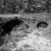
Findlayston Bridge


Road Bridge (Period Unassigned)
Site Name Findlayston Bridge
Classification Road Bridge (Period Unassigned)
Alternative Name(s) Slug Road; Cowie Water
Canmore ID 183756
Site Number NO88NW 41
NGR NO 84273 88361
Datum OSGB36 - NGR
Permalink http://canmore.org.uk/site/183756


- Council Aberdeenshire
- Parish Fetteresso
- Former Region Grampian
- Former District Kincardine And Deeside
- Former County Kincardineshire
NO88NW 41.00 84273 88361
Findlayston Bridge [NAT]
OS (GIS) MasterMap, October 2010.
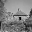
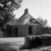
NO88NW 41.01 NO 84276 88386 Tollhouse (Ury House, Lodge)
This bridge carries Slug Road (the A957 public road) over the Cowie Water about 3.8km NW of Stonehaven. The tollhouse NO88NW 41.01 stands about 20m NE.
Information from RCAHMS (RJCM), 19 October 2010.
Photographic Survey (June 1963)
Photographic survey by the Scottish National Buildings Record/Ministry of Work in June 1963.

