
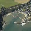
Stonehaven Harbour


Harbour (Period Unassigned)
Site Name Stonehaven Harbour
Classification Harbour (Period Unassigned)
Alternative Name(s) Stonehaven Bay; Stanehyve; Shore Head; Harbour Of Stonehaven; Shorehead
Canmore ID 36938
Site Number NO88NE 56
NGR NO 87764 85415
NGR Description Centred NO 87764 85415
Datum OSGB36 - NGR
Permalink http://canmore.org.uk/site/36938


- Council Aberdeenshire
- Parish Dunnottar
- Former Region Grampian
- Former District Kincardine And Deeside
- Former County Kincardineshire
NO88NE 56.00 centred 87764 85415
Inner Dock [NAT] (at NO 8774 8534)
Fish Jetty [NAT] (at NO 8773 8539)
Old Pier [NAT} (at NO 8781 8542)
The Breakwater [NAT] (at NO 8792 8542)
OS 1:10,000 map, 1989.
NO88NE 56.01 NO 87760 85399 Fish Jetty, Crane
NO88NE 56.02 NO 87776 85403 South Pier, Hand Crane
NO88NE 56.03 NO 87749 85352 Inner Dock
NO88NE 56.04 NO 87773 85404 to NO 87811 85395 to NO 87815 85360 to NO c. 87746 85272 South Pier
NO88NE 56.05 NO 87762 85397 to NO c. 97697 85401 Fish Jetty
NO88NE 56.06 NO 87807 85434 to NO c. 87854 85494 Old Pier
NO88NE 56.07 NO 87938 85403 to NO c. 87909 85491 The Breakwater
NO88NE 56.08 NO 8773 8550 Harbour Office
NO88NE 56.09 NO 87812 85397 South Pier, Pilot Beacon ('Stonehaven 1')
NO88NE 56.10 NO 87699 85430 and NO 87689 85432 Leading Lights ('Stonehaven 2' and ''Stonehaven 3')
NO88NE 56.11 NO 87943 85407 The Breakwater, Pilot Beacon
For adjacent Old Tolbooth and granary (10 Shore Head), see NO88NE 20 and NO88NE 98, respectively.
See also:
NO88NE 370 NO 87742 85249 Lifeboat Station
NO88NE 371 NO 87752 85239 Old Lifeboat Station
Location formerly entered as NO 87830 85462.
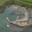
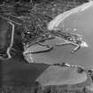
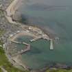
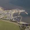
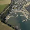
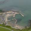
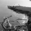
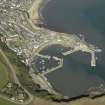
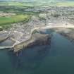
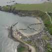
(Location cited as NO 878 853). Stonehaven Harbour, rebuilt 1826 by engineer Robert Stevenson. A natural harbour, improved by two curved piers, which, with two later piers, form two inner basins and an outer haven. The original rubble works have been modified recently with steel sheet piling.
J R Hume 1977.
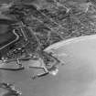
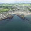
(Location cited as NO 87 85). Stonehaven Bay is a shallow indentation in the coast, about a mile in length, into which debouch the Cowie and Carron Waters with their mouths less than half a mile apart. Immediately S of the latter, a rocky point called Bellman's Head projects into the bay, cutting off a pocket-like cove between itself and Downie Point, which bounds the bay on the S. It is this pocket, and not the mouth of either of the streams, that forms the site of the hrabour and of the old town (NO88NE 52) that it served.
The earliest evidence for a port at what was then called Stanehyve seems to be a confirmation charter of 1587 to George, Earl marischal, for the twon with a free port, port dues, petty customs, anchorage fees, etc. This reference to a free port, however, does not necessarily imply the presence of harbour-works, nor do similar provisions in subsequent charters, of 1592 and 1612 help to illuminate this point. Comparison suggests itself with a document which states that the burgus at the mouth of the Cowie Water was vetusta magis quam opulenta for lack of a shore or sea-port for ships; but this passage must relate to some period in the more or less distant past as the note goes on to show that harbour-works of a kind were in existence in the earliest years of the 17th century. Thus it records that the first harbour was built by the Earl marischal on the open shore, that it was ruined by a storm during construction, and that it was was being repaired at the time of writing with the help of voluntary contributions from all the burghs in the country. The operations may therefore be associated with the call for contributions made by the Convention of Royal Burghs in 1612 and it is worth remarking that the word used here is 'reparatione', not new construction, while it appears further that the Convention had in fact been receiving similar applications for help in repairs since at least 1601. Continuing involvement of the Earl Marischal in the harbour's affairs is proved by the Convention's instruction that the voluntary payments are to be made 'as they sall be requyrit by my Lord Marschall or his doer'. Similar applications for help in harbour repairs were made to the Royal Burghs in 1649, 1665, 1679, 1698 and 1705, and particular interest attaches to the grant of ?300 made, after an inspection, in 1698, as this was cited by the twon as a roof of its poverty in applying to Parliament for help in the following year.
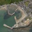
Whatever may have been the character of the harbour in the 17th century, by 1794 it consisted of nothing more than an open-ended basin in the NW corner of the pocket cited above. It was sheltered on the SE by a 'high rock', presumably Downie Point, and on the NE by a quay, aligned to the SE but swinging at its head towrads the SW, which was no doubt founded on the rocks Bellman Head. A pier is marked in this position on Roy's Map of 1747-55. The writer of the account of 1794 called for this pier to be extended, and for another to be built out towards it to enclose the basin; the depth at its entrance was 22 ft (6.7m).
Later developments are described in an account of 1842, according to which, although the harbour was easy to approach in easterly gales, its internal arrangements had formerly been so bad that shipping avoided it in winter. In 1825, however, it was put into the hands of Commissioners, who spent ?8000 on improving it to plans by Robert Stevenson. This work entailed the removal of a mass of rocks at the harbour entrance, perhaps the origin of the 'stane' in the name 'Stanehyve', and the building of a pier some 500 ft (152.4m) long which ran up, from the S, towards the S end of the old pier, leaving an entrance-gap between them. This arrangement still proved unsatisfactory through lack of an outer breakwater to cover the entrance, but the defect was overcome by returning the end of the S pier landwards for about 100 ft (30.5m) and building out a jetty some 200 ft (61m) towards it with an entrance between them wide enough to admit a ship. In this way there was formed a protected inner basin in the S part of the pocket, both basins being flanked on the W by a gently-curving 'Shore' some 900 ft (274m) long, which may or may not have been formed as part of the same programme. Both parts of the harbour were tidal, except at the entrance, and in 1847 the area was given as 5 acres, with the depth at the pier-head of 15 ft (4.6m) at springs. The account of 1842 records the usual range of imports and exports, the chief items of the former being coal and lime, and of the latter, grain, potatoes, fish and whisky. Steamships were calling on the run between Leith and Aberdeen.
A Graham 1979.
OSA; NSA.
Air photographs: AAS/94/18/G36/1-11.
NMRS, MS/712/21.
Location cited as NO 8778 8541: air photographic imagery listed.
NMRS, MS/712/35.
Publication Account (2007)
Although a harbour existed at Stonehaven from at least the 17th century, it was reportedly in a poor state until improvements, including construction of the seawall and breasting of the new harbour to the south and other
work, designed by Robert Stevenson, were carried out in 1825–26. Before this there was a single pier to which an enclosing pier (1825–26) and an internal jetty (1837) were added to form a double basin. The trade at the harbour increased and by 1895 more than 100 herring boats were
fishing from the port each season.
Stevenson’s son Thomas, in his text book on the design and construction of harbours in 1864, provides an illustrated section of, presumably, the 1825–26 pier noting that the string or bottle course at roadway level facing thesea had to be hewn off to inhibit shaking of the masonry during storms.
The mass concrete breakwater protecting the harbour entrance was built to a design by J. Barron in ca.1901.
The harbour is now the largest recreational facility of its kind in Aberdeenshire, with three basins extending to 412 acres in area.
R Paxton and J Shipway, 2007.
Reproduced from 'Civil Engineering heritage: Scotland - Highlands and Islands' with kind permission from Thomas Telford Publishers.
Publication Account (2013)
A good natural harbour formed by a bay and a rocky headland, with some of that rock incorporated into the low quay walls in the C16-C17th centuries. A sundial is fixed to the steps in front of the old tolbooth and a pier was added in 1700. Robert Stevenson advised that a stone stack (the stone in the haven?) be blown up to facilitate construction in 1826 of the south pier. This was followed by an internal jetty in 1837, forming three basins. A mass concrete breakwater completed the enclosure in 1901. There is a pilot beacon at the end of the breakwater and two leading lights in boxed lanterns, one fixed to a granary, now restaurant, the other fixed to a wooden post.
Ref: Angus Graham, 1979; Paxton and Shipway 2007.
M Watson, 2013

