
Arbuthnott


Pit(S) (Period Unassigned), Ring Ditch (Period Unassigned)
Site Name Arbuthnott
Classification Pit(S) (Period Unassigned), Ring Ditch (Period Unassigned)
Alternative Name(s) Arbuthnott Home Farm, Dark Avenue; Arbuthnott House Policies
Canmore ID 232617
Site Number NO77NE 82
NGR NO 7905 7528
Datum OSGB36 - NGR
Permalink http://canmore.org.uk/site/232617


- Council Aberdeenshire
- Parish Arbuthnott
- Former Region Grampian
- Former District Kincardine And Deeside
- Former County Kincardineshire
NO77NE 82 7905 7528
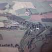
Oblique aerial photography (RCAHMSAP 2001) has recorded the cropmarks of a ring-ditch adjacent to a tree-lined avenue (NO77NE 70). The ring ditch measures about 15m in diameter within a ditch about 1-2m across and there may be an entrance on the NW.
Information from RCAHMS (SMDG) 8 January 2003

