
Kincardine Castle


Castle (13th Century)
Site Name Kincardine Castle
Classification Castle (13th Century)
Canmore ID 36061
Site Number NO67NE 10
NGR NO 67124 75109
Datum OSGB36 - NGR
Permalink http://canmore.org.uk/site/36061


- Council Aberdeenshire
- Parish Fordoun
- Former Region Grampian
- Former District Kincardine And Deeside
- Former County Kincardineshire
NO67NE 10.00 67124 75109
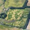
NO67NE 10.01 66 77 to 66 78 Royal (King's) Deer Park
(NO 6710 7510) Kincardine Castle (NR) (remains of)
OS 1:10,000 map, (1977)
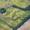
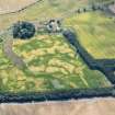
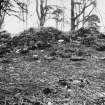
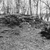
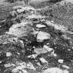
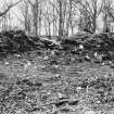
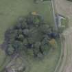
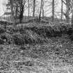
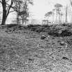
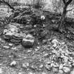
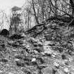
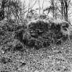
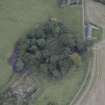
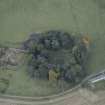
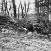
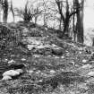
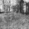
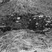
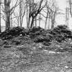
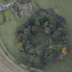
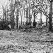
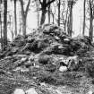
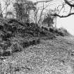
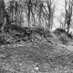
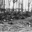
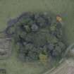
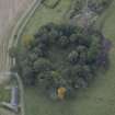
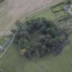
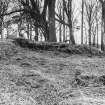
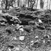
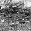
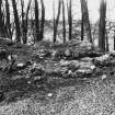
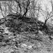
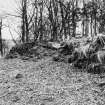
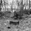
The remains of Kincardine Castle, of simple curtain wall type, stand on a natural, wooded hillock formerly surrounded by marsh which would make any outworks superfluous, although the site is said to be terraced in front with indications of a drawbridge and moat (Watt 1914).
Now 5 to 6ft in maximum height, the remains reveal a quadrangular plan fully 130ft square with rectangular gate-towers on the S and a thick outer wall with sloping plinth. Remains of apartments lie round three sides of the interior.
D MacGibbon and T Ross 1887-92; J C Watt 1914.
Kincardine Castle is generally as described by MacGibbon and Ross (1887-92), but now greatly obscured by vegetation. Outside the castle in the E and S is a scarp, which could be the remains of an original defence, mutilated by trees and a now overgrown 19th century track, surrounding the castle. This is undoubtedly the terrace described by Watt. His drawbridge is probably the access way to the above track and a hollow immediately to the E of it, fronting the scarp, gives the impression of the remains of a ditch.
Revised at 1:2500.
Visited by OS (ISS) 13 August 1971.
Listed.
Scottish Castle Survey 1988; N Bogdan and I B D Bryce 1991.
Field Visit (February 1982)
Kincardine Castle NO 671 751 NO67NE 10
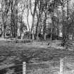
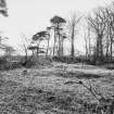
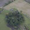
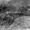
The royal castle of Kincardine, probably built for Alexander 11 in the years between 1217 and 1227, is situated on a bluff 100m NE of Castleton of Kincardine farmhouse. It measures about 35m square within a heavily robbed curtain-wall 2.4m in thickness; the main entrance is on the S (where there is a gatehouse), with a postern on the N, and there are ranges of buildings along the N, E and S sides.
RCAHMS 1982, visited February 1982
(MacGibbon and Ross 1887-92, iii, 111-12; Dunbar and Duncan 1971, 8-11)
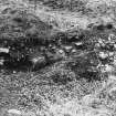
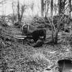
Excavation (3 July 2013 - 15 July 2013)
NO 671 751 Excavations were carried out, 3–15 July 2013, as part of the Scottish Medieval Deer Parks project, and involved the opening of a trench in a room on the E side of the S entrance into the castle. The trench exposed mortar-bonded wall faces up to 0.75m high and located a roughly-laid stone floor below layers of demolition material, which produced pieces of pig and cattle bone. A small sherd of ceramic (possibly a mould) was also recovered from the floor surface. A piece of pig bone from demolition material above the stone floor was radiocarbon dated to 885 +/- 34 BP which calibrates at AD 1040 to 1220 at 95.4% probability.
Archive: RCAHMS
Funder: Kevin Malloy, University of Wyoming
Derek Hall, 2013
(Source: DES)
Conservation
NO 67124 75109 A programme of landscape, buildings and
materials analysis is being carried out at Kincardine Castle
within the framework of this project. Buildings analysis of
the fragmentary remains of Kincardine Castle identified high
kiln relict concentrations within the constructional masonry
mortar of the structure’s curtain wall, and highlighted the
potential for further lab-based analysis of these materials
to inform our understanding of the building’s construction
and chronology. A sampling programme was subsequently
undertaken, and the assemblage ultimately included 13 fuel
relict inclusions and 3 mortar fragments from in situ and
loose contexts.
Lab-based analysis of the Kincardine Castle assemblage
included thick and thin section microscopic analysis of
one mortar sample. These analyses confirmed that the
constructional mortar was a wood-fired limestone-lime,
tempered with a lithic aggregate, and suggested that the
limestone had been sourced from a local metamorphic
outcrop. Microscopic analysis of the fuel assemblage
confirmed the assemblage was dominated by wood-charcoal
of mixed taxonomies.
Archive: NRHE (intended)
Funder: University of Stirling and Historic Environment Scotland

