
Smiddyhill


Enclosure (Period Unknown)
Site Name Smiddyhill
Classification Enclosure (Period Unknown)
Alternative Name(s) Stracathro
Canmore ID 168327
Site Number NO66NW 89
NGR NO 6145 6598
Datum OSGB36 - NGR
Permalink http://canmore.org.uk/site/168327


- Council Angus
- Parish Stracathro
- Former Region Tayside
- Former District Angus
- Former County Angus
NO66NW 89 6145 6586
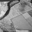
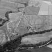
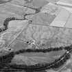
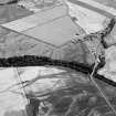
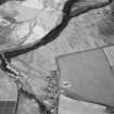
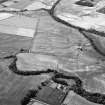
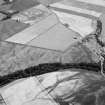
(Location cited as NO 6145 6586). Smiddyhill. Air photography (AAS/00/11/G27/15-16, flown 20 July 2000) has recorded the cropmark of a circular enclosure at an altitude of 45m OD. It is situated on the E [NE] side of the Roman temporary camp (NO66NW 13) at Stracathro, and within the scheduled area of both this camp and of the Roman fort NO66NW 18.
NMRS, MS/712/96.
NO 614 658 Cropmark of circular enclosure lying on E side of Roman camp.
Sponsors: Aberdeenshire Council, Angus Council
M Greig 2000.

