
Randerston Castle


Castle (Medieval)
Site Name Randerston Castle
Classification Castle (Medieval)
Alternative Name(s) Randalstown
Canmore ID 331690
Site Number NO61SW 42
NGR NO 61779 10885
Datum OSGB36 - NGR
Permalink http://canmore.org.uk/site/331690


- Council Fife
- Parish Kingsbarns
- Former Region Fife
- Former District North East Fife
- Former County Fife
NO61SW 4 61790 10900
(Name: NO 6192 1094) Randerston Castle (NAT)
OS 6" map (1938).
See also NO61SW 5 and NO61SW 42
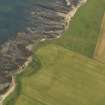
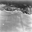
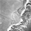
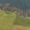
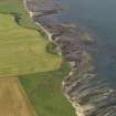
The castle of Randerston, mentioned in 1528 (C Rodgers 1877) stood on the shore, over 1/2 mile E of the late 16th century Randerston House (NO61SW 5) which superseded it. The lands of 'Randalstown' are recorded in 1429, and the 'tower, fortalice and manor-place' in the 1663 (Reg Magni Sig Reg Scot).
RCAHMS 1933
No trace of a castle was seen in the area. The name 'Randerston Castle' on OS 6" refers to a natural rock feature on the shore (Name Book 1854).
Visited by OS (WDJ) 3 September 1968
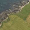
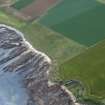
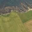
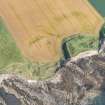
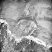
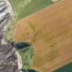
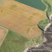
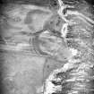
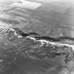
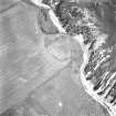
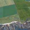
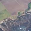
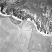
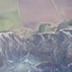
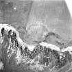
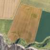
NO 617 109. Air photographs reveal cropmarks of three concentric ditches, the innermost of which is markedly broader than the other two, drawn across the neck of a short, blunt promontory. This change in construction could represent a strengthening of the defences of an Iron Age fort, but as a castle is attested here (RCAHMS) it seems more
likely that in this case a prehistoric site has been modified for re-use in or before the early 16th century.
H Welfare 1980.
Site recorded by Maritime Fife during the Coastal Assessment Survey for Historic Scotland, Fife Ness to Newburgh 1996.

