
Pricing Change
New pricing for orders of material from this site will come into place shortly. Charges for supply of digital images, digitisation on demand, prints and licensing will be altered.
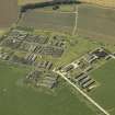
Crail Airfield


Building (20th Century)
Site Name Crail Airfield
Classification Building (20th Century)
Alternative Name(s) Crail Airfield Defences
Canmore ID 83708
Site Number NO60NW 49.08
NGR NO 61396 09324
Datum OSGB36 - NGR
Permalink http://canmore.org.uk/site/83708


- Council Fife
- Parish Crail
- Former Region Fife
- Former District North East Fife
- Former County Fife
NO60NW 49.08 61396 09324
A brick and concrete building on the NW side of Crail Airfield (NO60NW 49.00), now in ruins.
J Guy 1994; NMRS MS 810/3
An accommodation building for Crail Airfield.
Information from Mr I Brown to RCAHMS, 19 October 1998
This unroofed accommodation building stands in a small wood about 418m SE of Wormiston House (NO60NW 24) and NW of the large extant accommodation camp near Kirklands Farm.
The unroofed building measures about 34m x 6m overall, has two small annexes at each end. The interior has one large room with two smaller ones at the NE end. A small stove with and boiler are extant in the small compartment.
The purpose of this building remains unknown, the fact that it is completely separate from others in the Crail Airfield complex suggests a use other than accommodation.
Visited by RCAHMS (DE), 16 May 2007

