
White Caterthun


Ring Ditch House (Prehistoric)
Site Name White Caterthun
Classification Ring Ditch House (Prehistoric)
Canmore ID 68706
Site Number NO56NW 43.02
NGR NO 5491 6605
Datum OSGB36 - NGR
Permalink http://canmore.org.uk/site/68706


- Council Angus
- Parish Menmuir
- Former Region Tayside
- Former District Angus
- Former County Angus
Field Visit (29 September 1989)
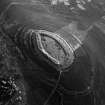
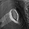
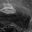
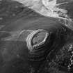
NO56NW 43.02 5491 6605.
The northerly of the two houses adjacent to the White Caterthun fort, this ring-ditch house measures 11.4m from NNE to SSW by 10.7m transversely over a shallow ditch 2.7m in breadth. The entrance is again on the downslope side, marked by a gap in a low external bank. On the uphill side the inner lip of the ditch peters out, but the outer lip continues as a scarp about 0.3m high.
Visited by RCAHMS (SH) 29 September 1989.

