
White Caterthun


Archaeological Landscape(S) (Prehistoric)
Site Name White Caterthun
Classification Archaeological Landscape(S) (Prehistoric)
Canmore ID 68779
Site Number NO56NE 32
NGR NO 551 661
Datum OSGB36 - NGR
Permalink http://canmore.org.uk/site/68779


- Council Angus
- Parish Menmuir
- Former Region Tayside
- Former District Angus
- Former County Angus
Field Visit (29 September 1989)
NO56NE 32.00 551 661
NO56NE 32.01 NO 5507 6611 Ring-ditch House
NO56NE 32.02 NO 5509 6607 Ring-ditch House (possible)
NO56NE 32.03 NO 552 660 Small cairns
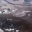
There are at least one, and probably two, ring-ditch houses situated in the saddle due E of the White Caterthun fort (NO56NE 17). There is also a scatter of small cairns in the vicinity.
Visited by RCAHMS (SH) 29 September 1989.

