
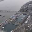
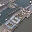
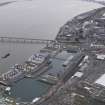
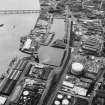
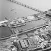
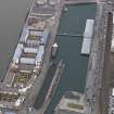
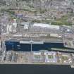
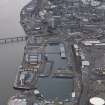
Dundee, Camperdown Street, Victoria Dock, East Graving Dry Dock


Dock (19th Century)
Site Name Dundee, Camperdown Street, Victoria Dock, East Graving Dry Dock
Classification Dock (19th Century)
Alternative Name(s) East Graving Dock; Dundee Harbour; Port Of Dundee; River Tay; Firth Of Tay
Canmore ID 72772
Site Number NO43SW 122
NGR NO 41151 30413
Datum OSGB36 - NGR
Permalink http://canmore.org.uk/site/72772


- Council Dundee, City Of
- Parish Dundee (Dundee, City Of)
- Former Region Tayside
- Former District City Of Dundee
- Former County Angus
NO43SW 122.00 41151 30413
East Graving Dock [NAT]
OS (GIS) AIB, April 2006.
NO43SW 122.01 41216 30418 Pump House
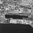
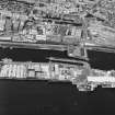
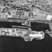
For Victoria Dock (centred NO 40958 30366) and associated buildings, see NO43SW 89.00.
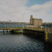
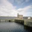
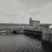
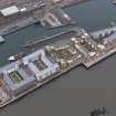
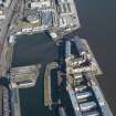
The entrance-gate at the W end of this dock is a rare example of a swinging caisson type.
Information from RCAHMS (RJCM), 18 April 2006.
Publication Account (2013)
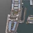
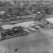
EAST GRAVING DOCK: Built in 1873 and measuring 157.28m (516ft )
in length, this dock has a floating caisson dock gate and stepped ashlar sides. Its pump house, containing modern pumps, has a dramatic lean
because it stands on made-up ground. The timber storage sheds south of these have been replaced by new apartments. The West Dry Dock depicted
in the Telford Atlas, is filled in, its site the car park and landscaping to the south of the Apex Hotel, Dock Road.
M Watson, 2013

