
Scheduled Maintenance
Please be advised that this website will undergo scheduled maintenance on the following dates: •
Tuesday 3rd December 11:00-15:00
During these times, some services may be temporarily unavailable. We apologise for any inconvenience this may cause.
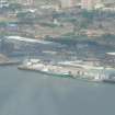
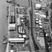
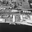
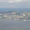
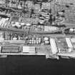
Dundee, East Camperdown Street, King George V Wharf


Transit Shed(S) (19th Century) - (20th Century), Wharf (Period Unassigned)
Site Name Dundee, East Camperdown Street, King George V Wharf
Classification Transit Shed(S) (19th Century) - (20th Century), Wharf (Period Unassigned)
Alternative Name(s) Dundee Harbour; Port Of Dundee; River Tay; Firth Of Tay; King George V Wharf Road
Canmore ID 33461
Site Number NO43SW 111
NGR NO 41677 30500
Datum OSGB36 - NGR
Permalink http://canmore.org.uk/site/33461


- Council Dundee, City Of
- Parish Dundee (Dundee, City Of)
- Former Region Tayside
- Former District City Of Dundee
- Former County Angus
NO43SW 111.00 41677 30500
Location formerly cited as NO 414 304.
NO43SW 111.01 NO 415 304 Cranes
For general summary of Dundee Harbour and the Port of Dundee, see NO43SW 109.
King George V Wharf [NAT]
OS (GIS) AIB, April 2006.
This wharf occupies a length of the N bank of the River Tay to the E of the entrance to Camperdown and Victoria Docks (NO 4139 3046). A travelling crane system (NO43SW 111.01) runs along its length.
The location assigned to this record defines the centre of the length of the wharf. The available map evidence indicates that it extends from NO 41485 30423 to NO 41901 30591.
Information from RCAHMS (RJCM), 18 April 2006.

