
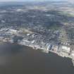
Dundee Harbour


Harbour (Period Unassigned)
Site Name Dundee Harbour
Classification Harbour (Period Unassigned)
Alternative Name(s) River Tay; Tay Estuary; Firth Of Tay; Port Of Dundee; H.m. Submarine Base, Hms Ambrose
Canmore ID 33458
Site Number NO43SW 109
NGR NO 41 30
Datum OSGB36 - NGR
Permalink http://canmore.org.uk/site/33458


- Council Dundee, City Of
- Parish Dundee (Dundee, City Of)
- Former Region Tayside
- Former District City Of Dundee
- Former County Angus
NO43SW 109 41 30
See also:
NO42NW 22.00 NO c. 4045 2985 Dundee, Old Harbour (includes summary of early harbour works at Dundee)
NO42NW 22.01 NO 4044 2982 Craig Pier (Old Ferry Pier)
NO42NW 157.00 NO 4046 2985 Craig Harbour
NO42NW 184 NO 40578 29985 Earl Grey Dock, entrance lock
NO42NW 185 NO 40578 29985 Earl Grey Dock, entrance lock, swing bridge
NO42NW 186.00 NO 40394 29812 Riverside Drive, Discovery Point (RRS Discovery visitor centre)
NO43SW 20 NO c. 427 310 Stannergate, midden (harbour extension)
NO43SW 51 NO 4033 3014 Old Custom House (Crichton Street)
NO43SW 481 NO 40680 30319 (present) Custom House (Dock Street)
NO43SW 64 NO 42915 30765 Stannergate, Caledon East Wharf
NO43SW 89.00 centred NO 40958 30366 Victoria Dock
NO43SW 90.00 centred NO 41322 30540 Camperdown Dock
NO43SW 110.00 NO 41310 30331 Queen Elizabeth Wharf
NO43SW 111.00 NO 41677 30500 King George V Wharf
NO43SW 112 NO 41947 30581 Caledon West Wharf
NO43SW 113 NO 42322 30696 Stannergate, Caledon Street, Eastern Wharf
NO43SW 114 centred NO 4279 3087 Caledon Shipyard
NO43SW 122.00 NO 41151 30413 Victoria Dock, Dry Dock (East Graving Dock)
NO43SW 138.00 NO 42089 30647 Stannergate, Princess Alexandra Wharf
NO43SW 156.00 NO 42556 30759 Stannergate, Fish Dock (Tidal Harbour)
NO43SW 712 NO 40853 30132 HMS Camperdown (Royal Naval Reserve training centre)
NO43SW 1001.00 centred NO 40691 30065 Tidal Harbour
NO43SW 1002.00 centred NO 40604 30182 King William IV Dock
NO43SW 1003 NO 42460 30701 Eastern Wharf, Ferry Terminal
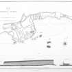
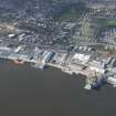
(Location cited as NO 410 303). [Dundee] harbour. The old harbour and docks, built 1815-30, were filled in when the Tay Road Bridge was under construction, but the Victoria and Camperdown Docks, built 1863-75, survive. The former is a roughly rectangular basin, with a graving dock on the south side, and the latter is irregularly shaped. The passage between them is spanned by a graceful two-leaf hand-operated iron swing footbridge. Both docks have single-storey cast- and wrought-iron-framed transit sheds along their north quays, and there is a 5-storey and attic, 5-bay, coursed rubble warehouse with a clock tower.
J R Hume 1977.
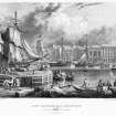
(Location cited as NO 40 30). Dundee: the natural advantages for maritime trading that Dundee must have enjoyed throughout its history are summarised by the Commissioners for Tidal Harbours in their report of 1847: 'Situate on the north bank of the estuary of the Tay - so far a deep navigable river at all states of the tide - in the midst of a fertile and prosperous country, the seat of extensive manufactures, holding a favourable position with respect to the Baltic, whence the chief part of its raw material is obtained, Dundee has great advantages for an extensive coasting and foreign traffic, which have been well seconded by the energy of her merchants and shipowners'. They might well have added that the estuary above Dundee, in its final reach to Perth, is bedevilled by shallows and sandbanks.
The earliest notices of the harbour perished with the rest of the burgh's records during the English occupation of 1547-8, but it is clear that the port was trading with some wine-growing region, very probably Bordeaux, at least as early as 1262, when 16 pipes of wine were landed for transference to Forfar. In 1393 customs were being collected were being collected at the port in a regular manner, and an allusion in the burgh's charter of 1447 to anchorage fees 'as use and custom is, and was in tyme by gane' is a further indication that the port was no new institution. The site of the early medieval is given by Maxwell as a natural haven just W of the Castle Rock, no tributary stream entering the Tay hereabouts to provide a naturally sheltered refuge; he quotes the same charter as stating that it was unsafe, and as authorising the burgesses and merchants themselves to undertake the construction and maintenance of a harbour permitting large or small ships to enter in leave in safety. He believes that this harbour was small, and he gives its boundaries, in the terms of his own day, as Castle Lane [name centred NO 4042 3024] on the N, the lower end of Tyndal's Wynd [unlocated] on the W, and the line of Crichton Street [name centred NO 4033 3016] projected seawards on the W. Whether or not as part of the same operation, a sea-wall was built on Butchers Row [unlocated] and the older harbour behind it was filled up and reclaimed; but this wall was later superseded by the New Shore [unlocated], set further forward and in deeper water - the term 'Shore' being used here, as so often elsewhere, as the name of a length of combined street and quay, with houses on its landward side and open wharfage opposite. Maxwell's account of these works suffers from a confused chronology - for example, in the passage just referred to he dates the New Shore to the end of the 15th century, but in another to only a short time before the building of the Packhouse [unlocated], the date of which is securely recorded as 1643. Two 'bulwarks' were also erected at some date which must have been earlier than 1567, as in that year they, along with the pier, haven and shore, were described as ruinous: these bulwarks were detached breakwaters partially enclosing an outer harbour, and seem to have been openwork wooden structures of piles and planking, though the rest of the works were of masonry. By 1581 the bulwarks were tending to lean over inwards, and ships were accordingly instructed to attach their cables to the outer timbers and to lead them in through the openwork construction; but this was later filled in and ballasted with material from a pier which was no longer needed. The bulwarks were strengthened in 1582.
From the 17th and 18th centuries some further notes are available on the harbour's affairs. In 1606 and again in 1610 the burgh was applying for an impost for the 'reparatioun of their schore and herbere', and in 1612 the place was described as a 'commodious haven', but in 1668 it was struck by a violent storm and 'utterly demolished'. For its repair an impost was granted on wine sold in the burgh, valid for 5 years, and by 1678 it could be said that the 'harbour, by great labour and expense, has been rendered a very safe and agreeable station for vessels'. A Macfarlane document of slightly later date records that 'the toune has a good shoar well built with hewen stone with a key, on both sides whereof they load and unload their ships with a great house on the shore called the packhouse where they lay up ther merchant goods'. This description seems to agree with that of Defoe, whose continuator records that 'it is rather a mole than a harbour, having no backwater to clean it; and that there are three entrances into it which may contain a hundred sail of ships, but not of great burthen'.
In 1700 and 1711 impositions for repairs were applied for in the usual way, and in 1717 a fresh subject appears in the records - that of silting, already the subject of a hint in Defoe's account just quoted. In the year that followed, as the town's trade increased and larger ships came into more general use, silting evidently became an increasingly serious drawback, and in 1717 the burgesses appealed to the Convention of Royal Burghs 'shewing that their harbour is so filled up that unless it is specially cleansed it will be impossible for ships to go out and in. The matter remained under discussion until 1724, when £40 sterling was granted for 'preventing further ruine of their harbour'. Makeshift remedies, however, seem to have been going out of fashion as the century advanced, and a series of radical improvements, which set the harbour on the road to its modern form, began in 1770, when J Smeaton was called on for advice. The principal stages of the work carried out thereafter are noted in the New Statistical Account of 1833, and individual operations undertaken from time to time are described in the Parliamentary Report of 1847.
The harbour of Smeaton's day measured only 4.5 acres [1.8ha] and comprised two protective piers, E and W, and two detached breakwaters (to seaward), these latter providing one main and two narrow entrances. There was also a scouring basin of 1/3 acre [0.13ha]. At about this time the harbour could be described (in the New Statistical Account) as 'a crooked wall, often enclosing but a few fishing or smuggling craft'. It was liable to silting by debris washed in from higher up the Tay, and to counter this tendency Smeaton recommended some re-arrangement of the scouring sluices, and the opening up of tunnels in the protective piers, to provide freer passage for the tidal currents. These recommendations were only carried out in part, but in 1788 the enclosed area was enlarged by the building of a pier running W from the end of the E protective pier, and in 1803 a detached breakwater was added. It was in 1814, however, that the crucial point was reached in the harbour's development, when R Stevenson advised the construction of a series of wet docks running eastwards from the existing harbour behind a sea-wall.
With this plan, T Telford agreed, and in 1815 an Act was passed placing the management of the harbour in the hands of Harbour Commissioners, who then proceeded with works recommended in a second report recommended in a second report by Telford. There now followed the construction of a wet dock, King William IV Dock (NO43SW 1002.00), of 6.25 acres [2.5ha], with a tidal entrance-harbour (NO43SW 1001.00) and a graving-dock (NO42NW 1002.03); its E protection-wall apparently served as a quay on its outer side. The W protection-wall, which was finished in 1820, was 24ft [7.3m] high and battered to a width of 12ft [3.66m] on the top; its outer face was of hammer-dressed blocks set obliquely, without mortar, and the hearting was of quarry rubbish. In 1831 there followed, to the W of this work, Earl Grey's Dock (Earl Grey Dock: NO43SW 515), of 5.25 acres [2.1ha], designed by J Gibb, with a scouring-tunnel and a landing-slip for the Tay ferry from Newport.
In 1830, another civil engineer, J Jardine, considered that Dundee's growing needs could best be met by adding further wet docks to the E of the existing one, and accordingly in 1833 work began on a dock of 11.5 acres [4.7ha] in that position. On the Admiralty plan of 1846 it is named Victoria Dock (NO43SW 89.00) and is marked as 'now building', as is also an 11-acre [4.5ha] tidal harbour connecting with it on the E. East again of this last, the same plan marks a 'projected dock' of 9.5 acres [3.8ha]. The Parliamentary Report of 1847 sums up the condition of the harbour at that date, but in doing so seems to borrow largely from a report made to the Admiralty in 1844 by Captain Washington, RN. That officer wrote, in part, 'Two spacious wet docks, containing an area of 11.5 acres [4.7ha], area already completed and in full activity; another wet dock, of more than double the extent, is laid out; with two tidal harbours, one of 5 acres [2ha], now in use, the other of 11 acres [4.5ha]; besides graving-docks, patent slips and every facility for a first-rate commercial port'. He foresees, however, that silting may still take place along the faces of the quays, and at the entrances of the tidal basins; and he notes the danger of the rocks in front of the harbour and their influence on the silt-bearing tidal currents.
A Graham 1979.

