
Lundin Bridge


Anti Tank Blocks (20th Century)
Site Name Lundin Bridge
Classification Anti Tank Blocks (20th Century)
Alternative Name(s) Tentsmuir Coastal Defences
Canmore ID 84177
Site Number NO42NE 73
NGR NO 46760 27905
NGR Description From NO 46468 28542 c.NO 4731 2772
Datum OSGB36 - NGR
Permalink http://canmore.org.uk/site/84177


- Council Fife
- Parish Ferry-port-on-craig
- Former Region Fife
- Former District North East Fife
- Former County Fife
NO42NE 73 From 46468 28542 to c.4731 2772
For other military command, training and defensive structures on Tentsmuir Sands, see also:
NO42NE 71-2, 117 and 127
NO42SE 56-7, 77-9 and 81
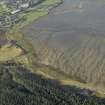
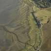
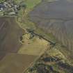
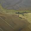
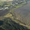
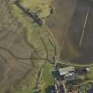
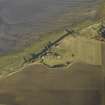
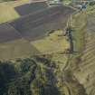
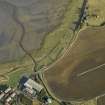
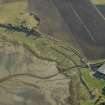
A double row of anti-tank blocks are situated to the N of Lundin Bridge. The WW2 blocks have been constructed using corrugated iron shuttering and have rounded tops. A further series of anti-tank blocks are visible along the shore to the E.
J Guy 1994; NMRS MS 810/3, 132-3.
The anti tank blocks noted above (Guy 1994) survive in short sections and small groups. At NO 46468 28542, immediately S of Snook Head, a few blocks can be seen built in to the edge of the low cliff at the edge of the public park, to try and alleviate coastal erosion. The blocks are not visible along the coast under recent deliberate rock dumping from this point until a crossing over a burn at Links Road North immediately S of a small caravan park at NO 46484 28203, where four blocks were noted, two each side of the burn. The line of blocks has been removed between the burn and NO 46743 72930 about 44m N of Lundin Bridge where the double line re-appears. The two lines of blocks then run as far as c.NO 4731 2772, where they have again been removed with a further line some distance to the E.
The continuous line of blocks orignally built are visible on vertical air photographs taken in 1946 (106G/UK 1, part I, frames 6149-6150 and 6181-6182, flown 10 April 1946). The line of blocksis also depicted on the current OS digital maps and annotated as 'breakwaters'.
Visited by RCAHMS (DE), 26 November 2008

