
Balmerino Abbey, Monk's Well


Watermill (Period Unassigned), Well (Period Unassigned)
Site Name Balmerino Abbey, Monk's Well
Classification Watermill (Period Unassigned), Well (Period Unassigned)
Canmore ID 31749
Site Number NO32SE 2.03
NGR NO 3589 2474
Datum OSGB36 - NGR
Permalink http://canmore.org.uk/site/31749


- Council Fife
- Parish Balmerino
- Former Region Fife
- Former District North East Fife
- Former County Fife
NO32SE 2.3 3589 2474.
(NO 3589 2474) Monks' Well (NR).
OS 6" map (1921)
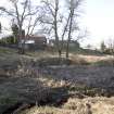
The Monks' Well lies a short distance NE of the Abbey.
RCAHMS 1933, visited 1927
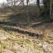
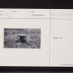
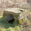
This well is a small stone-lined compartment 1.0m square and 0.8m high, still containing water. It is situated in marshy ground close by a stream.
Visited by OS (JLD) 2 November 1956
The well is generally as described by OS (JLD), although the coverstone of the compartment has been removed. Name confirmed.
Visited by OS (RD) 11 June 1970.
Field Visit (March 2010)
The Cistercian abbey of Balmerino is situated on a terrace overlooking the Tay estuary. Founded in 1226/7 by Alexander II and Queen Ermengarde, it was burned by the English in 1547 and raided by reformers in 1559. After the Reformation the abbey was granted to a series of commendators, who may be responsible for some of the changes which may be seen in the buildings. It was subsequently erected into a lordship for the Elphinstone lords of Balmerino. However, most of the demolition of the surviving buildings appears to have carried out in the early seventeenth century by the second Lord Balmerino for use in the repair of the church at Monifieth.
The Monastic Buildings
The surviving features comprised fragments of the abbey church (NO32SE 2.06), the east range, the freestanding building to the east known as the Abbot’s House (NO32SE 2.01) and the large two storey building known as the Abbey Barn to the north (NO32SE 2.02), which was incorporated in the Improvement Period farmsteading (NO32SE 2.04). Nothing of the precinct wall now remains. Campbell (1899, 301) speculates about its course across the field to the south of the abbey church, which is now partly occupied by the almshouses. In this area, he observed a ridge from east to west across the field and identified it as the line of the wall. Although the plough had disturbed some stone work in this area on the date of survey, there was no visible topography to support it. Geophysical survey would be the best method of investigating this possibility.
The abbey is laid out according to a standard Cistercian design, but with the cloister to the north, as at Melrose. Nothing of the north and west range survive except for the raggles of the return of the cloister walls on the church and east range walls. Indeed, it is by no means certain that a west range ever existed since there is no raggle for a parallel wall to make the other side of the range, although there is space for it; because the facings of the wall have been robbed at this point, a range may be inferred. However, the basal chamfer of the cloister wall along the north side of the church runs under the raggle which suggests that the original design of the west range had been changed. Campbell refers to a large building used as stables in the area of the farmhouse, which may have been the west range designed to provide accommodation for the conversi (Campbell 1899, 298).
The east range does not now extend far enough to show any trace of the other wall of the north range. It still stands to first floor level, and to the roofline on two sides of the chapter house. This building with its large mullioned windows and late Gothic vaulting is the most interesting architectural survival on the site. Its north end has been demolished and altered in its conversion to a house for the commendator. The east range includes, from south to north: the sacristry, the chapter house, the stairs to the dormitory, a passage or slype and some cellars, the latter probably belonging to the commendator’s house. The foundations of two parallel walls, revealed in the Scotia excavations to the north of the east range and which were aligned with it, have been interpreted as the east range extending 7–8 m further to the north. The refectory may be presumed to lie in the north range.
The so-called Abbot’s House (NO32SE 2.01) situated 35 m to the east is a two bay structure with a vaulted basement. Aligned on the same orientation as the rest of the monastery, it measured about 9.5 m by 7.5 m overall, on the assumption that the two basement chambers are of equal size, but it cannot have been much longer due to the cut of the river terrace immediately to the north. Its walls are 1 m thick and are partly faced with thin rubble slabs with some squared ashlar work, suggesting that it had been relieved of its dressed stone. The quoins of the openings are well-constructed in grey sandstone ashlar, as is the vault. There is a chamfered round arched entrance between the two chambers and window lights to east and west in the surviving chamber, with chamfered arrises. A secondary entrance has been cut in the west wall to the south of the window opening, which has been blocked and a press arranged in the blocking. The base of the window in the east wall has been partially blocked. As it stands, it would be small for an infirmary, the suggested alternative to an Abbot’s House. The shallow arched openings of the windows and the round-arched door between the two basements suggest a late medieval date. Campbell notes that it was once called the Commendator’s House and that this became the residence of Lord Balmerino (Campbell 1899, 299). He notes that it was once approached by a stair on its west, now gone, and had another on the east leading to a garden and a kitchen entrance, which may be the opening in the west of the basement.
To the north of the cloisters one abbey building still stands, the so-called Abbey Barn (NO32SE 2.02). This building measures 20 m WSW and ENE by 7.2 m in breadth over brown sandstone rubble walls, 0.9 m in thickness, increasing to 1.2 m at the gable. The building is a parallelogram aligned with the cloisters at the gable but orientated obliquely to the cloisters along its length, probably to avoid existing structures at its east end. It stands two storeys in height and has a steeply pitched roof. There is a scarcement along the inside of the walls above the ground floor windows to support the first floor joists. Any original window lights in the first floor might be expected to have dormers, since no obvious sign remains in the stonework. The skewput on the north-west corner of the building is decorated with a shield bearing an unidentified armorial device.
There is an entrance with a deeply chamfered gothic arch of late thirteenth century date 6 m from the west gable and another wider opening with similar chamfered quoins some 5 m further east. This is a double width entrance suitable for a barn, but its lintel is modern timber, and a two centred arch would leave a trace in the stonework above the entrance. The original opening could have been widened after the Reformation. The domestic scale of the entrance to the west is inappropriate in a barn and there would be less need for a first floor in a barn, although a loft would be a possibility. In between the two entrances there is a slit window with a square head, again of a domestic character. The excavations by Scotia revealed an extensive area of cobbles to the west of the building, with a distinct camber suggesting a roadway. The foundation of a thick wall ran up to the south end of the west gable on the same alignment, which may be the remains of a precinct wall enclosing the outer court of the monastery. Scotia also excavated a kiln, probably of seventeenth century date, in the east end of the barn.
Visited by RCAHMS (PJD) March 2010
Field Visit (March 2010)
The appearance on the first edition OS 6-inch map of a pair of mill-dams and ponds in the stream gull to the E of the monastic buildings was confirmation that there had been two mills on the unnamed burn that flows past the convent (Fife and Kinross, 1855, sheet 1). Both are documented in a late-16th century rental, where they are described as the Over Mill and the Nether Mill (Campbell 1899, 615-6). The Nether Mill, or Balmerino Mill, now known as the Abbey Mill (NO32SE 30), is of post-medieval date with Abbey stones re-used in its walls. It is an overshot mill with a wheel-pit at its NE end and a square hole for a shaft to be carried into the building in the middle of the wall. The mill building is an L-shaped structure, the long axis aligned from NE to SW that stands to two storeys, with an outshot extending under a sloping roof to the NW of the NE end, reroofed in recent conversion to domestic housing. Built with random rubble, the corners are finished with sandstone quoins and the entrance in the NW wall has chamfered quoins, shallow enough to be of post-medieval date. The window lights are a mixture of small square openings and slit windows with square heads, some clearly made with dressed stone from the Abbey. Two additions have been made to the SW of which one formerly contained a kiln. The mill was fed by a lade that was built up to c2m above the level of the wheel shaft to deliver water, presumably via a trough, now gone, to the top of the wheel. About 38m to the S of the building in the garden of the present house there is a stone lined run-off in the SW side of the terrace of the former lade, which is now used as a path. The course of the lade may be traced as a terrace on the E bank of the burn for about 120m to within a short distance of the stone-built bridge (NO32SE 92) that now carries a road, but was built as a dam and sluice on which a date stone at its foot on the S face indicates that it was built in 1743. The runners for the sides of the sluice can still be seen on the S parapet of the bridge and the small opening for the water at its base, through which the water of the burn now runs. About 100m further up the burn, just beyond the small rectangular sandstone-covered structure, known as the Monk’s Well (NO32SE 2.03), there is a flat-topped bank about 1.2m in thickness that extends some 25m from NW to SE on the NE of which is a 2m wide ditch that runs from a ruptured dam to a subrectangular hollow about 8m across that contains the so-called Monk’s Well, with some stonework visible in the bank on the N side. This is interpreted as the location of the Upper Mill, which in the absence of a pit is interpreted as an undershot or mid-shot mill fed by a lade from the dam to the SE.
Visited by RCAHMS (PJD) March 2010

