
Carpow


Cropmark (Period Unknown)
Site Name Carpow
Classification Cropmark (Period Unknown)
Canmore ID 73228
Site Number NO21NW 90
NGR NO 20930 18160
NGR Description Centred NO 20930 18160
Datum OSGB36 - NGR
Permalink http://canmore.org.uk/site/73228


- Council Perth And Kinross
- Parish Abernethy (Perth And Kinross)
- Former Region Tayside
- Former District Perth And Kinross
- Former County Perthshire
NO21NW 90 centred 20930 18160
See also NO21NW 62 and NO21NW 89.
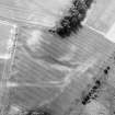
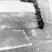
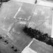
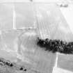
Aerial photography (RCAHMSAP 1990) has recorded a short L-shaped length of ditch about 100m NE of the Roman legionary fortress NO21NW 24.00. The date and purpose of this feature remain unclear.
Information from RCAHMS (JRS), 4 February 1997.
Aerial Photographic Transcription (31 December 1993)
An aerial transcription was produced from oblique aerial photographs. Information from Historic Environment Scotland (BM) 31 March 2017.

