
Wester Drumatherty


Souterrain (Prehistoric), Unenclosed Settlement (Prehistoric)
Site Name Wester Drumatherty
Classification Souterrain (Prehistoric), Unenclosed Settlement (Prehistoric)
Alternative Name(s) Spittalfield
Canmore ID 28938
Site Number NO14SW 20
NGR NO 1155 4119
Datum OSGB36 - NGR
Permalink http://canmore.org.uk/site/28938


- Council Perth And Kinross
- Parish Caputh
- Former Region Tayside
- Former District Perth And Kinross
- Former County Perthshire
Field Visit (12 November 1975)
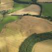
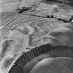
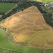
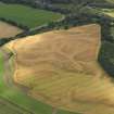
There is no trace of these crop marks, located on the top of a river terrace on gravel. Only one of the features at NO 1160 4118 appears to be a ring ditch. It measures approximately 30.0m in diameter.
Visited by OS (NKB) 12 November 1975.
Excavation (1987)
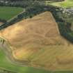
Prehistoric structures comprised two circular palisaded homesteads, a number of ring-ditch houses, at least one barrow, and several possible souterrains; the Roman presence was represented by traces of a well-built metalled road (NO14SW 30)
G S Maxwell and D R Wilson 1987
Aerial Photographic Interpretation (April 1993)
NO14SW 20 1155 4119.
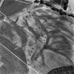
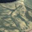
(NO 116 412) Cropmarks, ring ditches, Spitalfield. (Visible on AP's)
At least four crescent-shaped cropmarks, which probably mark the position of round-houses, together with what is probably a small souterrain or subterranean structure, are situated at the edge of a level terrace 350m W of Wester Drumatherty steading. Three of the crescents lie in echelon, two of them being enclosed by concentric palisade trenches, and the fourth is immediately to the N. The northernmost of the row is about 18m across and the surrounding enclosure is 30m in diameter; probing has shown that the crescent-shaped feature measures up to 1m in depth. On the S the enclosure adjoins the back of the second crescent, which also has traces of an enclosing 'halo'; this crescent measures about 15m across and the presumed enclosure some 26m in diameter. Within the interior of the enclosure there is an L-shaped feature, which probably indicates the position of a subterranean structure about 5m in length by a maximum of 2m in breadth. The two enclosures cannot have co-existed, and it is evident that the second enclosure must also intersect the third crescent, which is about 18m across. At the SE horn of this crescent there is a narrow mark forming three sides of a subrectangular shape some 6m in length, and there is also a rather angular macula a short distance to the S.
Information from RCAHMS (GSM) April 1993.
G S Maxwell 1982.
See also NMRS NO14SW 30, 66 and 79.

