
Inchtuthil


Mortuary Enclosure (Neolithic), Axehead (Iron)(Roman)
Site Name Inchtuthil
Classification Mortuary Enclosure (Neolithic), Axehead (Iron)(Roman)
Alternative Name(s) Inchtuthil Plateau
Canmore ID 68818
Site Number NO13NW 5.06
NGR NO 1254 3956
Datum OSGB36 - NGR
Permalink http://canmore.org.uk/site/68818


- Council Perth And Kinross
- Parish Caputh
- Former Region Tayside
- Former District Perth And Kinross
- Former County Perthshire
Excavation (1989)
NO13NW 5.06 1254 3956
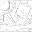
An area measuring 30m by 20m was opened over the eastern half of the prehistoric ditched enclosure, trenched in 1961 by Richmond and St Joseph during their investigation of the Roman legionary fortress. The enclosure had been discovered to be about 54m long and a maximum of 10m across, within the ditch, which was a maximum of c1.5m across and 0.9m deep. The excavations reported here showed that the ditch had been dug in linked segments on the long sides and was consequently irregular in line and dimensions. It had been used, when little more than half filled, as the bedding trench for what appeared to have been a wooden fence supported by substantial posts set at c0.8m intervals but
evidence of more than one phase of use of the ditch was recovered. The fence had been set on fire and, apparently while still burning, it had fallen, or had been pushed over, towards the interior of the enclosure. The continuous charcoal band thus produced indicated that the upright posts had been linked to form a continuous barrier. The gravel and sand immediately overlying the charcoal was in most places burnt bright red/orange, indicating that it had been deposited while the wood was still burning. The charcoal and red/orange layers were extensive, clearly defined and not redeposited. The burnt material had been dug through at a later stage. No contemporary artefact were found.
The growth of a large tree had disrupted the E end considerably, but some indications of a more complex arrangement of posts survived. The same tree had disturbed the upper fills of a Roman pit from which a Roman legionary axe, nails and coarse pottery were recovered. Within
the excavated area the S side of the enclosure had been overlain by the N ends of Roman Barrack-buildings numbers 5 and 6; the latter building , which was not uncovered in the earlier excavations, was represented by the post-pits of the veranda and the post-trenches defining the outer room of the northernmost contubenium. A fragment of amphora rim, discovered in the upper fill of the northernmost veranda post-pit of Barrack 5, was the only artefact directly associated with the Roman structures.
G J Barclay and G S Maxwell 1989
Note (9 December 1992)
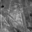
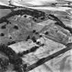
Air photography has recorded the cropmarks of a roughly rectangular enclosure within the Roman fortress NO13NW 5.00. These were first excavated in 1961 and examined in further detail in 1989, when it was found to measure 54m by up to 10m within a ditch about 1.5m broad and 0.9m deep. The ditch (which was cut by features of Roman date) had been dug in segments; in two of the identifiable phases, it had held a fence supported by posts of oak which had subsequently been set alight and collapsed. The only artifacts recovered in excavation were related to the Roman occupation of the site, but radiocarbon assay of burnt fence-timber produced a date in the late fourth or early third millennium BC.
Information from RCAHMS (JRS) 9 December 1992.
L F Pitts and J K St Joseph 1985; G J Barclay and G S Maxwell 1989; G J Barclay and G S Maxwell 1992.

