
Carnac, Moredun


Fort (Prehistoric)
Site Name Carnac, Moredun
Classification Fort (Prehistoric)
Alternative Name(s) Moncrieffe Hill; Moredun Top
Canmore ID 28025
Site Number NO11NW 23
NGR NO 1362 1999
Datum OSGB36 - NGR
Permalink http://canmore.org.uk/site/28025


- Council Perth And Kinross
- Parish Dunbarney
- Former Region Tayside
- Former District Perth And Kinross
- Former County Perthshire
Field Visit (14 October 1963)
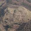
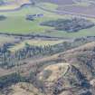
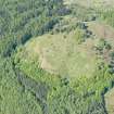
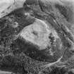
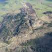
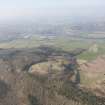
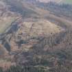
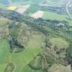
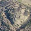
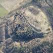
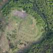
Centred at NO 1362 1999 this fort is generally as described and planned by Feachem (1963), Christison (1900) and Wainwright (1955). The dun-like structure described by Feachem consisting for most of its perimeter of a grassy scarp 2.0m maximum height on the south save on the west side where there is a bank with a maximum internal height of 0.5m and a maximum external height of 1.0m. Part of the East side, which may have contained the entrance, is very badly mutilated. Four slightly hollowed hut circles with an average diameter of 8.0m can be discerned in the interior and there are faint traces of a fifth 3.5m in diameter; their entrances are not apparent. Most of the smaller circles planned by Christison cannot now be discerned.
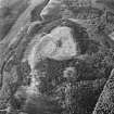
The dun-like structure lies within a larger enclosure 175.0m East to West by 100.0m North to South, the perimeter of which is shewn mostly by the scarping of the natural slopes though fragmentary remains of a rampart and evidence of of stony construction are to be seen here and there. It is best preserved on the East where the outward facing scarp is up to 1.0m high. The entrance is in the SE approached by a terraced way up the natural slope from the East.
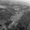
To the West the course of an outer rampart can be traced ... traced along the edge of what appears to be a natural terrace. The hillside below this has several natural terraces.
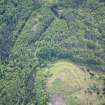
Adjoining the fort on the North an area 115.0m East to West by 80.0m North to South is enclosed by the remains of a stony rampart at best about 1.0m high but in many places consisting only of a scarping of the natural slopes. To the NW of this area there are indications of the triangular annex shown on Wainright's plan. No trace could be found of the Northern extension of the most Westerly rampart shown on the same plan due to a thick tree covering here. Most of the entire site has been reafforested.
Revised at 1/2500.
Visited by OS (R D L) 14 October 1963.
Sources: Christison 1900; Feachem 1963; Wainwright 1955.
Desk Based Assessment (2 October 1963)
NO11NW 23 1355 1995
Carnac Fort (OE) OS 6" (Prov.) 1938
"Moncrieffe Hill, Fort. This fort consists of an enclosure formed within two ruined walls and measuring 560 feet by 330 feet .... It has a dun-like structure measuring about 160 feet by 120 feet within a ruined wall originally about 12 feet thick which seems to overlie a sector of the inner wall of the larger enclosure. It may, indeed, have been built at a time after the large fort had been abandoned, possibly in fully post-Roman times. The presence both within and outside the smaller enclosure of circular stone foundations of houses suggests an occupation in later Roman times at the earliest" (R W Feachem 1963, 145).
The structural details of the nuclear fort on Moncrieffe Hill, known as Moredun, possess features which mark it distinctively as belonging to the Dark Ages. The fort acquires added importance in that the name, Moncrieffe, is considered quite possibly to be that Monad Croib (Monad Craebi) where a battle of high significance in the dynastic struggle for control of the Pictish ... Pictish Kingdom was fought, in 728, between Angus and Alpin.
Information from OS (SW) 2 October 1963.
Sources: Feachem 1963, Watson 1926.
Field Visit (12 December 1996)
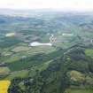
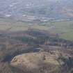
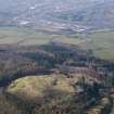
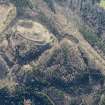
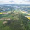
This important multiperiod fort crowns the summit of Moredun Top, the highest part of Moncrieffe Hill. Previous plans of the fort have only hinted at the extent of the surviving remains and a modern plan is required to set in context not only the sequence of rampart construction, but also the remains of round-houses, some of which are clearly later in date than the final period of the defences.
Visited by RCAHMS (JRS), 12 December 1996.
Management (16 February 2001)
[Re]-Scheduled as Moredun Top, fort.
Information from Historic Scotland, scheduling document dated 16 February 2001.
Field Visit (24 March 2014)
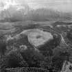
NO 13569 19990 Magnetic and resistivity surveys were carried out, 24 March – 15 April 2014, over the larger of the two hillforts on Moncreiffe Hill in advance of excavations planned by the Tay Landscape Partnership. The fort has a main enclosure c150 x 100m in size within which, at the highest part of the hill, is a smaller oval, walled enclosure of c60 x 40m. Below
the main enclosure, to the N, lie terraces associated with the fort. The survey covered most of the unforested section of the main enclosure. The magnetic data probably mostly reflects the local geology (the hill is composed of a series of lava flows) but some unusually magnetic areas have been defined which merit further investigation. The resistivity data shows the walls of the inner enclosure very clearly as well as a number of small round negative anomalies which might reflect the presence of
ancient structures within the main fort area or, alternatively, more recent excavations.
Archive: RCAHMS (intended)
Funder: Tay Landscape Partnership
Peter Morris and Tony Simpson – Blairgowrie Geoscience
(Source: DES)
Measured Survey (12 May 2014 - 15 May 2014)
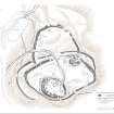
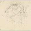
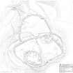
The fort on the summit of Moredun Top, Moncreiffe Hill, sometimes also referred to as Carnac, was surveyed by RCAHMS in May 2014. This note serves as a summary of the full site description which is available as a PDF (RCAHMS WP 003618). The drawn survey is available online as both the original drawing (SC 1425572) and as a final illustration (DP 203195 or WP 003616).
On the basis of field survey, the site comprises the following elements:
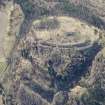
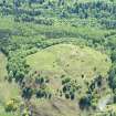
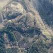
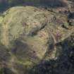
(A) A large mound, possibly a cairn, which stands within the E side of the interior and appears to comprise a grass-grown mass of loose stone measuring about 30m from E to W by 23m transversely and at least 1.5m in height.
(B) An oval enclosure measuring about 197m from ENE to WSW by 100m transversely (c1.5ha) within the remains of a thick stone wall.
(C) A second phase of fortification is represented by a sub-oval enclosure measuring about 170m from E to W by 103m transversely (1.15ha) within the remains of a thick stone wall
(D) Possibly in use contemporarily with the second phase enclosure is the large enclosure which appears to have been attached to its N side. This enclosure, which is roughly D-shaped on plan - the chord of the D formed by the wall of the second phase enclosure, measures 110m from E to W by 76m transversely, again within the remains of a thick wall.
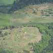
(E) The third phase of enclosure is a comparatively small but very thick-walled fort that crowns the highest part of the hill. Oval on plan, it measures about 53m from NW to SE by 38m transversely within a wall reduced to a stony bank up to 13m in thickness but no more than 1m in internal height.
(F) A phase of unenclosed settlement on the summit is represented by four hut-circles – three lying within the small summit fort and one immediately to the north.
In addition to these principal components, there is extensive evidence of quarrying – in the form of excavations into the solid bedrock and as shallower pits which have seen the removal of what is effectively loose rubble from archaeological features. Moreover, there is sufficient evidence in the form of trenching to demonstrate antiquarian investigation of the fort.
Visited by RCAHMS (GFG, JRS, IP), 12-15 May 2014.
Geophysical Survey (4 March 2015 - 22 April 2015)
NO 1360 2000 (NO11NW 23) Following work in 2014 (DES 2014, 161-162) further resistivity survey was undertaken, 4 March – 22 April 2015, at Moredun Top hillfort. Considerable tree felling had provided significant new open ground in the main enclosure and the decision was made to survey this first and then expand the area covered by surveying blocks around the circumference of the existing data.
The principal fort walls are now extremely well defined by the resistivity. They are probably very much drier than the soil in the interior of the fort, and subsequent excavation has shown that there are even significant void regions between many of the rocks in the walls. There are a number of small, sub-circular, features which could have been house sites but the most interesting feature is in the NE part of the site. Here there is a significant surface mound which from the resistivity appears to have a ring of boulders around it at the base with a less resistive zone in the centre.
Archive: National Record of the Historic Environment (NRHE) and PKHT (intended)
Funder: Tay Landscape Partnership/Perth and Kinross Heritage Trust
Peter Morris – Tay Landscape Partnership
(Source:DES, Volume 16)
Note (7 May 2015 - 4 January 2017)
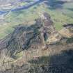
This fort crowns Moredun Top, which is the very highest of the summits along the Moncrieffe Hill ridge. Its defences represent at least four phases of construction, the earliest of which is a large oval enclosure with its rampart following a natural break of slope round the E, N and W flanks of the hill to enclose an area measuring 197m from ENE to WSW by 100m transversely (1.5ha). This is probably overlain on the ENE by the circuit of a second rampart following another break of slope set a little further back up the hill and enclosing an area measuring 110m from E to W by 76m transversely (0.65ha). A D-shaped annexe representing a third phase is apparently butted onto the N side of this enclosure, crossing the earlier rampart and looping round a series of shelves on the N spur to enclose an area measuring 110m from E to W along the chord formed by the second rampart by 76m transversely (0.65ha). On the E the rampart of the annexe returns into an area of shallow surface quarrying, which has not only obscured its relationship to the second rampart, but also the relationship of that rampart to a substantial stony mound measuring 30m from E to W by 23m transversely and at least 1.5m in height, which lies immediately within its line; it is unclear whether this is the remains of an earlier cairn occupying a false-crest position on the shoulder of the hill, or perhaps some substantial later structure such as a broch, dominating the view northwards across the Tay at Perth. Leaving this mound aside, a stone-walled enclosure on the very summit is likely to represent the fourth and last structural phase in the defences of the fort, though its relationship to the second rampart on the S cannot be demonstrated stratigraphically. Measuring 53m from NW to SE by 38m transversely (0.15ha) within a wall reduced to a mound of rubble up to 13m in thickness by 1m in height, a substantial external face has been exposed in what may be an undocumented antiquarian excavation on its W side. Three hut-circles, which can be seen within the N part of the interior of this small enclosure, and a fourth lying a short distance outside it, may represent a later, essentially, unenclosed settlement on the fort. The only other features of note within the overall area enclosed by the defences are a pond at the W end of the area enclosed by the second rampart. Apart from a source of stone, however, the summit has remained a natural vantage point long after the defences were abandoned and the site was evidently incorporated in a woodland setting into the design of the landscape around Moncrieffe House, which may account for the trackway driven through the W side of the annexe and up though what was probably an original entrance gap in the first two ramparts on the N, to cut across the wall of the summit enclosure on the NE; a socketstone for a flagpole set into the rubble of the wall on the S, and the anchor points for four stays, possibly mark its destination. Another trackway descends the S flank of the hill via what is probably another original gap in the second rampart.
Information from An Atlas of Hillforts of Great Britain and Ireland – 04 January 2017. Atlas of Hillforts SC3035
Archaeological Evaluation (1 September 2015 - 26 September 2015)
NO11NW 23 An archaeological excavation was undertaken by the Tay Landscape Partnership, with local volunteers, Perth and Kinross Heritage Trust and AOC Archaeology Group at Moredun Top hillfort. The works follow on from and compliment the earlier evaluation works completed at the adjacent site of Moncreiffe Hill, itself an Iron Age fort. The 2015 works formed the first season of an intended three year programme of excavations at the hillfort.
The 2015 works comprised five trenches, which investigated the three main lines of ramparts, an annex enclosure. Within the hillfort a large flat topped mound along with a double ring hut circle were investigated.
The excavation of the ramparts demonstrated that there was a complex sequence of enclosure at the hillfort. The trench excavated across the two main enclosing banks demonstrated that both of these had at least two separate phases of construction with primary earth banks being overlain by stone ramparts. A similarly long sequence of occupation deposits internal to the upper of the main rampart lines was recorded. Across all the lines of enclosure the massive and monumental nature of the dry-stone ramparts was revealed.
Excavations within the interior of the hillfort focussed on a flat topped mound. Here another large dry-stone wall was exposed probably the outer wall of a monumental roundhouse. In the interior of this structure were a series of in-situ burnt deposits probably derived from the burning of structural elements of the roundhouse. Limited excavation was also undertaken at a double ring hut circle within the interior.
A series of radiocarbon dates from across the site were obtained all of which dated to the 2nd half of the 1st millennium BC.
Information from OASIS ID: aocarcha1-243382 (J Humble) 2015.
Excavation (6 September 2016 - 1 October 2016)
NO 1362 1999 Phase 2 of a programme of archaeological work was undertaken, 6 September – 1 October 2016, at the hillfort of Moredun Top by Tay Landscape Partnership, led by Perth and Kinross Heritage Trust and delivered by AOC Archaeology Group and local volunteers.
Four trenches were excavated, located over potential features within the hillfort which were identified via topographic survey of the hillfort. Areas for investigation were selected based on previous work. Two adjacent
circular features in the upper citadel area and one smaller slightly outwith this area were target for investigation, as well as a larger circular stone feature uncovered during test pitting in 2015 and a pond area to determine the nature and construction of the pond feature.
Evidence of the structure and use of the hillfort was recorded in three trenches. In the upper area of the hillfort two curvilinear structures were identified, along with rubble and collapse material. A potential rampart with two defined courses was also exposed, via excavation of a sondage, which may have formed a boundary to the upper area. The relationship between these two features is still poorly understood. Associated artefacts recovered consisted of shale bracelet fragments and rough-outs, prehistoric pottery and coarse-stone tools.
The smaller circular feature consisted of an alignment of rough stone rubble and collapse material with associated prehistoric pottery and slag material within the stone. A small area of wall with two defined courses was uncovered in a sondage across the N edge of the trench.
Within the largest trench was a monumental circular stone feature built into the bedrock lying within a larger lower enclosure. A defined 2.5m wide entranceway was revealed with large amounts of burnt material enclosed within. The artefact assemblage associated with this feature consisted of a
stone lamp, lintel stone with possible pivot hole, cup-marked stones, shale bracelet fragments and prehistoric pottery. A pond feature was also investigated. Little artefactual or structural evidence was discovered to help understand the construction or chronology of this feature; however, a
palisade slot was discovered running through the trench.
The artefact assemblage of coarse-stone tools, pottery and metal objects, matched with the nature of the features investigated and suggests activity spanning from the Iron Age to the early historic period.
Archive: NRHE (intended)
Funder: Tay Landscape Partnership
David Strachan, Martin Cook, Sophie Nicol and Katie Roper – Perth and Kinross Heritage Trust, Tay Landscape Partnership and AOC Archaeology
(Source: DES, Volume 17)
OASIS ID: aocarcha1-333427
Excavation (25 April 2017 - 20 May 2017)
NO 1362 1999 Phase 3 of a programme of archaeological work was undertaken, 25 April – 20 May 2017, at the hillfort of Moredun Top by Tay Landscape Partnership, led by Perth and Kinross Heritage Trust and delivered by AOC Archaeology Group and local volunteers.
Five trenches were excavated, placed to investigate structures identified during topographic surveys and further explore features and areas uncovered in the 2015 and 2016 excavations. These included: circular structures, potentially roundhouses; a monumental structure, of which the exterior was investigated in 2016; a rampart wall discovered at the end of the 2016 season; and a pond feature. Excavations focused on four key areas across the hillfort: the upper area with two trenches excavated on the rampart wall identified through a sondage late in the 2016 season, and a more formal curvilinear structure found alongside a topographically identified circular structure (Trench A and B); the monumental stone structure located in the lower area (Trench C); a pond feature, located to the S of the large stone structure (Trench D).
The rampart wall, identified in Trench A in 2016 was monumental in scale, in parts stretching to >5m wide. This structure had an easily identifiable inner and outer face. As well as occupation layers, a possible hearth stone feature was identified above the rampart. A buried ground surface was exposed in a sondage against the inner face of the rampart, with no associated finds. Within the rampart were various pairs of stone alignments, probably representing voids for rampart timbers.
The curvilinear course of stone uncovered in the 2016 Trench B sondage was further explored to expose a further curved section of stone. This stone is likely to form part of a penannular structure, possibly an enclosure. Several artefacts were uncovered from the area abutting the enclosure, including a carved stone lamp, flint blade, linear decorated prehistoric ceramic and a spindle whorl.
The interior of the structure explored in Trench C showed evidence for a hearth feature, in situ burned interior deposits and evidence for interior timbers. The inner burned deposits may represent a destruction layer, as also seen in the orange/ black burning evidence in the entranceway during the 2016 excavations. Close to the hearth, amongst this interior burned deposit, was a cache of at least six bone points. Dense charcoal lenses provide evidence for likely timbers, either from the roof or structure itself (possibly in situ floor planks) or representative of an internal screening or partition. Further timber evidence was discovered in the interior of the entrance passageway.
An area of quarried bedrock and a rock cut face probably led to the retention of water in the pond area of Trench D. However, it is hard to ascertain if this was done intentionally, bedrock quarrying is present across the site. To the E of this feature is evidence for a palisade cut, as well as a possible enclosure wall. The system of ramparts investigated in Trench E showed multiple reuse of material over time. The outer wall of the dun feature in Trench C was identified, with a fill of compacted stone and possible kerbing. This material was later reused to form a bank, formed of large sub-rounded and squared stones, sat on a shattered stone layer. Post-dating the dun collapse and creation of this later bank, was a further rampart. Timber, debris and tumble was identified throughout the sloped trench, from the various structures. An original ground surface was present beneath the various structures and was exposed in three distinct areas of the trench.
The 2017 evidence helped to clarify the preceding excavations at Moredun, as well as add new information relating to the use, longevity and possible occupation of the hillfort complex. We have various finds suggesting occupation, including hints of a shale working industry, a spindle whorl, ceramic, two carved stone lamps found in different locations (2016: Trench C; 2017: Trench B) and in situ floor deposits in the internal areas of the dun structure in Trench C. The work has also highlighted the monumentality of the structures of Moredun; the dun structure in Trench C and the rampart in Trench A, as well as the reuse of material to form outer ramparts, probably after the collapse of the dun. Evidence for bedrock quarrying may provide an explanation for the nature of the pond feature. Also, further exploration of the structure in Trench B has found further artefacts to complement the decorative pin (2016), including a piece of linear decorated ceramic pottery. The artefact assemblage of coarse stone tools, pottery and metal objects, matched with the nature of the features investigated supports activity spanning from the Iron Age to early historic period.
Archive: NRHE (intended)
Funder: Tay Landscape Partnership
David Strachan, Martin Cook, Sophie Nicol and Katie Roper – Perth and Kinross Heritage Trust, Tay Landscape Partnership and AOC Archaeology Group
(Source: DES, Volume 18)

