Pricing Change
New pricing for orders of material from this site will come into place shortly. Charges for supply of digital images, digitisation on demand, prints and licensing will be altered.
Lui Water
Corn Drying Kiln (Post Medieval), Kiln Barn (Post Medieval), Township (Post Medieval)
Site Name Lui Water
Classification Corn Drying Kiln (Post Medieval), Kiln Barn (Post Medieval), Township (Post Medieval)
Alternative Name(s) Mar Lodge Estate; Glen Lui; Rintion; Ruighe An T-sidhein; Derry Lodge
Canmore ID 27757
Site Number NO09SE 1
NGR NO 0618 9182
Datum OSGB36 - NGR
Permalink http://canmore.org.uk/site/27757
- Council Aberdeenshire
- Parish Crathie And Braemar
- Former Region Grampian
- Former District Kincardine And Deeside
- Former County Aberdeenshire
NO09SE 1 062 918
Footings of depopulated township on SW-facing slope. Footings of longhouses with field banks, enclosures and areas of rig .
NMRS, MS/712/9.
Observation (1987)
Within felled plantation (at least 120 years old when felled in the 1940s), a series of settlement structures. Rig and furrow system on floodplain beyond Fairy Hillock. The structures comprise longhouses, 8m by 4m and 14m by 5m, and two others 12m by 4m, each with stumps within foundations. Below track a 4m-diameter sub-circular foundation, probably a kiln and a 13m by 6m longhouse, cut diagonally across by track. Also a massive 1.5m broad curvilinear wall. A longhouse, 10m by 5m, with traces of enclosures upslope. On the mound beside the river a small rectangular structure with kiln at end.
J S Smith 1987.
Field Visit (23 June 1993)
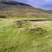
On a SW-facing hillside there are the remains of eleven buildings and huts, a kiln, two small enclosures and stretches of bank. On the haugh below the slope there are traces of rig, and, set into a knoll beside the Lui Water, there is a second kiln. Many of the buildings have been disturbed, either by the track to Derry Lodge, which passes through the site close to the bottom of the slope, by drainage ditches, or by the plantation, now felled, which formerly cloaked the hillside above the track. This plantation is depicted on the 2nd edition of the six-inch map (Aberdeenshire 1903, Sheet xcvii) but does not appear on the 1st edition of 1869 (Aberdeenshire 1869, sheet xcvii).
With the exceptions of two buildings cut by the track, (MAR93 36-7) and two huts (MAR93 30, 32), the buildings measure between 8.1m and 11.7m in length and between 2.3m and 3.6m in breadth within faced-rubble walls 0.7m to 1m in thickness and up to 0.6m in height. Most of them are set parallel to the contour, often with one side dug into the slope, and, in four cases, there is a drain around the upper side. They are mostly rectangular with rounded corners, though occasionally one end is rounded and in at least two cases (MAR93 27 and 31) the side walls are bowed. Entrances are almost all to be found on the downslope side. Two buildings have subrectangular enclosures attached to them, and a stony bank running between two buildings (MAR93 28-9) and beyond to the S, defines part of the E edge of the settlement. Apart from the two kilns, it is only possible to suggest a specific function for one building, (NO 0622 9180; MAR93 27), which is built at right angles to the slope and has two opposed entrances, possibly indicating its use as a winnowing barn.
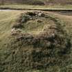
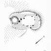
One of the two kilns stands at the bottom of the hillside. Set into the hillside, it has a stone-faced, subcircular bowl 1.5m in diameter within a bank 1.3m in thickness, the flue opening to the SW (NO 0618 9182; MAR93 26). The other kiln is situated about 150m to the SSW of the other buildings at NO 0614 9170. Set into the NE side of a knoll, its circular bowl measures 1.8m in diameter and 1.3m in depth within a faced-rubble wall 0.9m thick. On its NE side there is an attached barn measuring 3.7m by 2.9m within a wall measuring 0.8m in thickness and 0.7m in height (MAR93 25).
To the SW of the township there is an area of flat, well-drained haughland, bounded by the Lui Water on the S and W and by boggy ground on the N, amounting to some 4ha in all, about two-thirds of which bears traces of rig cultivation. The township is depicted on Roy's map (Roy 1747-55) as Rintion, which is rendered in gaelic as Ruighe an t-Sidhein (Watson and Allan 1984).
(MAR93 25-37)
Visited by RCAHMS (SDB) 23 June 1993.
Measured Survey (24 June 1993)
RCAHMS surveyed the corn-drying kiln at Lui Water on 24 June 1993 with alidade and plane-table at a scale of 1:100. The resultant plan was redrawn in ink and published at a scale of 1:200 (RCAHMS 1995b, Fig. 14).


