
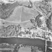
Dunkeld


Burgh (Medieval), Town (Period Unassigned)
Site Name Dunkeld
Classification Burgh (Medieval), Town (Period Unassigned)
Canmore ID 27192
Site Number NO04SW 37
NGR NO 0265 4264
NGR Description Centred NO 0265 4264
Datum OSGB36 - NGR
Permalink http://canmore.org.uk/site/27192


- Council Perth And Kinross
- Parish Dunkeld And Dowally
- Former Region Tayside
- Former District Perth And Kinross
- Former County Perthshire
NO04SW 37 centred 0265 4264
See also NO04SW 46 (Old Bridge).
Dunkeld was in existence as a burgh of barony in 1511/12; ineffectively erected as a royal burgh in 1704.
G S Pryde 1965.
Dunkeld is on record as a burgh of barony in 1511/12, at which date it was granted augmentation of privileges, including a weekly market and annual fair; the mercat cross (NO04SW 10) was removed about 1800.
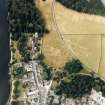
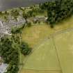
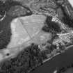
The extent of the burgh is revealed by Slezer's (1693) 'Prospect of the Town of Dunkeld', which broadly conforms to the present street layout; a windmill (NO04SW 28), the remains probably of Bishop Cardeny's tower (NO04SW 15), the cathedral (NO04SW 1.00) and, on the N, Dunkeld House (NO04SW 16), can all be identified, while a hospital within the burgh is on record in 1506 (NO04SW 2). All but three of the houses in the burgh are said to have been destroyed by fire following the battle of Killicrankie in 1689; only one 17th-century house, Dean's House (NO04SW 14), now survives. The sites of other tenements are indicated by blocked door and window openings in the E precinct wall of the cathedral.
A plan of 1822, annotated 'houses in Dunkeld, now thrown into the lawn' (Atholl Muniments), depicts, perhaps schematically, a group of properties peripheral to the cathedral on the N and W (formerly the houses of the secular canons) which were bought up and levelled by the Atholls to make way for the policies of Dunkeld House (cf. 'Plan of Lawns. After 1821', Atholl Muniments D3.34), the earliest of these properties, dated 1592. There are no visible remains of any of these properties, but cropmarks to the N of the cathedral (NO04SW 16) indicate a number of linear features which may be roads, foundations and boundaries of this date.
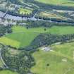
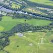
The Tay is said to have been bridged at Dunkeld by 1461. No trace of this bridge remains, nor of that built by Bishop George Brown (begun 1513), although the latter is said to have stood close to the Bishop's Palace, to the S of the Cathedral.
Visited by RCAHMS (IMS) March 1990.
Dunkeld Rentale; J Slezer 1693; J Stobie 1783; G S Pryde 1965.
These notes were prepared from an examination of post-reformation feus mainly of prebendial mansions in Dunkeld from the printed SRO volumes of the Register of the Great Seal covering 1580-1633, and other sources including on-line. The research was carried out in Northampton using sources to hand, and as with 'Notes on the Medieval town of Scone' produced 20th May last year, demonstrates the need for more thorough documentary research on key medieval towns in Scotland.
The research provided the following insight into the town or city of Dunkeld:
1. That the medieval town lay west and east of the Cathedral, along much the axis of the present Cathedral Street, with the Cathedral standing about the centre of the town, as suggested in the New Statistical Account (p960). After being destroyed by fire in 1689 Dunkeld was rebuilt east of the Cathedral only, and the houses and gardens to the west and north-west of the Cathedral, occupying about five acres, was never rebuilt and became part of the Duke of Atholl's park (Old Statistical Account p413; NSA p960, 962).
2. That part of the medieval town lay south of the River Tay at Little Dunkeld, known in some documents as the Burgh of Little Dunkeld.
3. That the Bishop's Palace may have been south-west of the Cathedral as suggested in the New Statistical Account p972-3. Also one document refers to 'lie muthill' here, which might signify a motte.
4. That the original site of St George's Hospital may have been west of the Cathedral prior to 1689, even if it was rebuilt subsequently in 1757 to the east, where Ell House stands.
5. That the mansion house of the Duke of Atholl prior to 1653 may have been east of the Cathedral.
Dr Thomas C. Welsh, 2008.
EXTERNAL REFERENCE:
National Library, Edinburgh - 'Sketches of Scottish Scenery', p.30 - one sketch.
National Library, Edinburgh - Nattes drawings, Vol 2. No26 and Vol 3. Nos 65/67 - four drawings.
National Library, Edinburgh - Nattes drawings, VOL 2, Nos: 1 & 5 - Dunkeld Farm.

