
Goodlieburn


Cross (Period Unassigned)
Site Name Goodlieburn
Classification Cross (Period Unassigned)
Alternative Name(s) Goodlieburn Cross; Goodlyburn Farm
Canmore ID 26879
Site Number NO02SE 3
NGR NO 0950 2431
Datum OSGB36 - NGR
Permalink http://canmore.org.uk/site/26879


- Council Perth And Kinross
- Parish Tibbermore
- Former Region Tayside
- Former District Perth And Kinross
- Former County Perthshire
NO02SE 3 0950 2431
(NO 0950 2431) Cross (NR) (Site of)
OS 6"map, Perthshire, 2nd ed., (1901).
See also NO01NE 220.
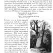
Description of the Stone Cross: Surveyed, 28th April 1798. This cross stands in the midst of a corn field, part of the farm of Goodlyburn.
The Cross, which would seem to have been the Market Cross of Ruthven Barony, is one single stone piece of freestone. The overall height is about 12', 9' 6" of which rises above the pedestal; the shaft tapers from 2' 3" at bottom to 1' 4" at top, and is 9" thick.
R S Fittis 1876.
The stone at Goodlieburn, near Perth, is a solitary example on the east coast of Scotland of a pillar with a figure of Our Lord in relief.
J Stuart 1856.
According to Mrs Galloway, King's Well, No.30 Burghmuir Rd., Perth, the cross now stands in Forteviot Churchyard (NO01NE 10.3; NO 05 17).
Visited by OS (J L D) 16 December 1960.
The report that the cross had been moved to Forteviot is an error. It now stands on the Dupplin Estate, having been moved there prior to 1924 (for which, see NO01NE 220).
Information from RCAHMS (IFr), 17 July 2009 and email from G Forsyth, 16 July 2009.

