
Logierait


Linear Feature (Period Unassigned), Pit(S) (Period Unassigned), Roundhouse(S) (Prehistoric)(Possible), Souterrain (Prehistoric)(Possible)
Site Name Logierait
Classification Linear Feature (Period Unassigned), Pit(S) (Period Unassigned), Roundhouse(S) (Prehistoric)(Possible), Souterrain (Prehistoric)(Possible)
Alternative Name(s) Claisandear
Canmore ID 26334
Site Number NN95SE 29
NGR NN 96992 51989
Datum OSGB36 - NGR
Permalink http://canmore.org.uk/site/26334


- Council Perth And Kinross
- Parish Logierait
- Former Region Tayside
- Former District Perth And Kinross
- Former County Perthshire
NN95SE 29 970 520
See also NN95SE 32.
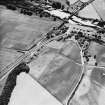
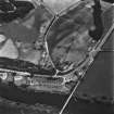
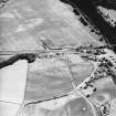
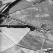
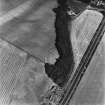
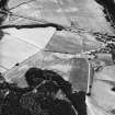
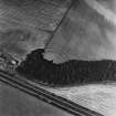
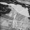
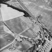
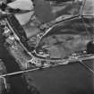
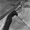
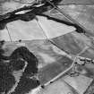
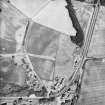
Aerial photography has revealed a series of cropmarks across two fields 90m to the N of Claisandear farmsteading. Settlement remains include a possible souterrain, approximately 8m long, and two dark indistinct sub-circular marks (possibly round-houses or hut bases) centred on NN c.9700 5200. These traces are located on a promontory and 'enclosed' by a linear cropmark (NN c.9697 5201 to NN c.9720 5204) which is visible immediately to the N. Two further possible round-houses have been recorded 210m to the ENE, and in the area between there are further indeterminate cropmarks, an arc of ditch, and a number of pits. The cropmarks of a fort are situated on a promontory to the S (NN95SE 32).
Information from RCAHMS (KB) 19 August 1999
Scheduled as Logierait, fort, souterrains, roundhouses, pits and enclosure.
Information from Historic Scotland, scheduling document dated 16 February 2001.
Aerial Photographic Transcription (1 April 2012)

