
Glen Devon


Cist (Period Unknown)(Possible), Motte (Medieval)(Possible)
Site Name Glen Devon
Classification Cist (Period Unknown)(Possible), Motte (Medieval)(Possible)
Alternative Name(s) Upper Glendevon Reservoir
Canmore ID 25949
Site Number NN90SW 1
NGR NN 90407 04675
Datum OSGB36 - NGR
Permalink http://canmore.org.uk/site/25949


- Council Perth And Kinross
- Parish Blackford
- Former Region Tayside
- Former District Perth And Kinross
- Former County Perthshire
NN90SW 1 9041 0467
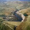
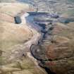
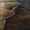
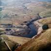
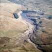
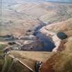
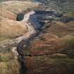
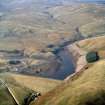
(NN 9041 0467) (Visible on RAF air photographs 106G/Scot/UK 120: 3321-2: flown 20 June 1946). A motte in Glen Devon at the confluence of a small stream issuing from Glen Bee and the River Devon, is a symmetrically-shaped truncated and flattened cone, partly surrounded in horseshoe formation by a deep ditch and an earthen rampart.
J M Davidson 1952.
This motte has completely disappeared beneath the waters of a new reservoir.
Visited by OS (W D J), 27 June 1967.
This possible motte and cist have been recorded on oblique aerial photographs (RCAHMSAP 2003), during low water levels in the Upper Glendevon Reservoir.
Information from (ALD), 24 May 2004.
Measured Survey (27 October 2003)
A GPS survey of the possible motte and cist was undertaken by RCAHMS in October 2003. Water levels in the Upper Glendevon Reservoir had fallen substantially leaving the site exposed. The survey included recording of the location of the edge of the possible cist and the collection of numerous points and lines to enable the creation of a 3D model of the possible motte.
Measured Survey (8 October 2003)
A GPS survey of the archaeology within the area of the Upper Glendevon Reservoir was undertaken by RCAHMS on 8th October 2003. Water levels in the reservoir had fallen substantially over the summer and autumn leaving the sites exposed.

