
Camelon - Ardoch - Strageath - Cargill Roman Road


Quarry Pit(S) (Roman), Roman Road (Roman)
Site Name Camelon - Ardoch - Strageath - Cargill Roman Road
Classification Quarry Pit(S) (Roman), Roman Road (Roman)
Alternative Name(s) Rr 9a
Canmore ID 25381
Site Number NN81SW 40
NGR NN 84796 11162
NGR Description NN 8411 1000 to NN 8499 1146
Datum OSGB36 - NGR
Permalink http://canmore.org.uk/site/25381


- Council Perth And Kinross
- Parish Ardoch
- Former Region Tayside
- Former District Perth And Kinross
- Former County Perthshire
NN81SW 40 8411 1000 to 8499 1146 (RR7) (formerly NN81SW 8888 RR 9a)
ROMAN ROAD
(course of) [R]
[name centred NN 8476 1010]
OS 1:10,000 map, 1982.
For other elements of Ardoch, Roman Military Complex , see:
NN80NW 10 NN 8390 0990 Fort
NN80NW 32 NN 8425 0999 Fort (Formerly entered as Temporary Camp)
NN81SW 7 NN 8452 1075 Watch Tower (Scheduled as Signal Station)
NN81SW 15 NN 8390 1090 Temporary Camp ('63 acre')
NN81SW 16 NN 8370 1060 Temporary Camp ('30 acre')
NN81SW 17 NN 8380 1050 Temporary Camp ('13 acre': within NN81SW 16)
NN81SW 18 NN 8420 1080 Temporary Camp ('120 acre')
NN81SW 19 NN 8404 1022 Temporary Camp (Scheduled as Annexe to Fort NN80NW 10).
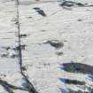
NN 8411 1000 The causeway can be traced without break from Ardoch Fort for over a mile
NN 8445 1056 causeway plain - pebbly
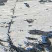
NN 8451 1066 six quarry pits
NN 8471 1103 causeway of pebbles can be traced continuously
NN 8478 1113 many small river boulders
NN 8488 1130 change of direction
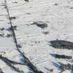
NN 8489 1131 - NN 8499 1146 visible as light mark on aerial photographs (541/A/396/3343-4)
NN 8495 1140 causeway visible
OGS Crawford 1949
From Ardoch to Strageath it is marked continuously by the OS. Crawford (1949) investigated the whole route at various times between 1925 and 1940. Except for short lengths, he found the course correct, and viable remains in many places.
Information from OS (DJC) 1966.
O G S Crawford 1949.
(NN 8387 0975 - ) NN 8411 1000 - NN 8419 1093 no definite traces
NN 8419 1093 - NN 8428 1034 extant
NN 8428 1034 - NN 8541 1053 no trace
NN 8541 1053 - NN 8456 1095 extant
NN 8456 1095 - NN 8500 1146 (- NN 8526 1179) no definite trace
Visited by OS (EGC) June 1967
The road between Greenloaning (NN 83 07) and Strageath (NN 89 17) was found to be fairly well-defined in places and best preserved at NN 890 173; where the agger is 1.0m high. The most notable deviation from the OS published course occurs in NN 85 12.
Information from OS (EGC) August 1967.
Scheduled as 'A stretch of the Roman road... from the forts at Camelon to Bertha... [which] survives as a slight causeway running north-east for 1.2 km from the fort [NN80NW 10]'.
(Scheduled length indicated on Scheduling map as extending from NN 8425 1034 to NN 8486 1127].
Information from Historic Scotland, scheduling document dated 26 March 2008.

