
Strageath


Fort Annexe (Roman)
Site Name Strageath
Classification Fort Annexe (Roman)
Alternative Name(s) Strageath Mains
Canmore ID 25297
Site Number NN81NE 2.01
NGR NN 8964 1802
Datum OSGB36 - NGR
Permalink http://canmore.org.uk/site/25297


First 100 images shown. See the Collections panel (below) for a link to all digital images.
- Council Perth And Kinross
- Parish Muthill
- Former Region Tayside
- Former District Perth And Kinross
- Former County Perthshire
Field Visit (26 November 1997)
NN81NE 2.01 8964 1802.
Excavations of this fort between 1973 and 1986 indicated three successive phases of military occupation with a complete remodelling of the defences on each re-occupation. The Flavian fort was built in the late 1st century AD, perhaps as early as AD 80, with evacuation no later than AD 87. The second fort (Antonine I) was built about AD 142, this occupation coming to an end within the period AD 155-8. By AD 158, however, the site was reoccupied (Antonine II), before being finally evacuated by AD 164 at the latest (Frere and Wilkes 1989). A recent assessment of the Antonine occupation of Scotland has cast significant doubt on whether there was a distinct Antonine II phase, suggesting instead a single 2nd century occupation (Hodgson 1995). While the weight of excavated evidence from Strageath indicates two distinct Antonine phases, in the light of this research it may be more appropriate to see this in terms of rebuilding rather than reoccupation after a period of abandonment.
Excavation was confined to the fort and did not investigate the complex of annexes to the W. Prehistoric activity on the fort site is attested through the excavations, both through the identification of cultivated soils under the rampart and in the recovery of a few artefacts. Pottery dating from the earlier half of the 1st millennium BC and possibly also from the 3rd millennium BC were recovered, together with a collection of undiagnostic flints. The tip of a fine Mesolithic blade (NN81NE 2.04) was found in the interior of the fort in March 1997.
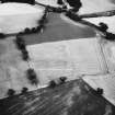
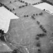
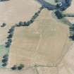
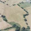
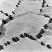
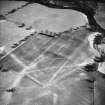
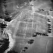
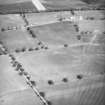
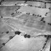
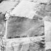
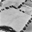
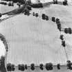
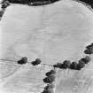
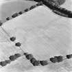
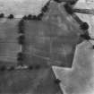
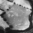
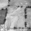
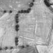
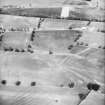
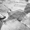
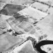
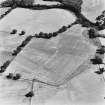
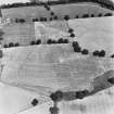
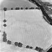
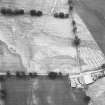
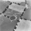
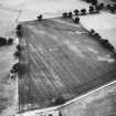
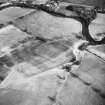
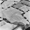
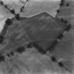
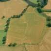
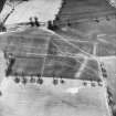
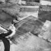
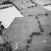
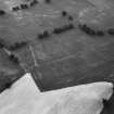
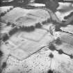
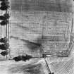
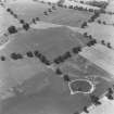
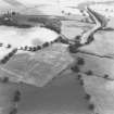
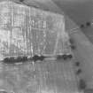
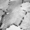
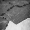
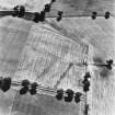
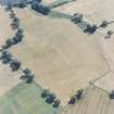
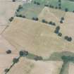
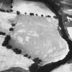
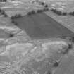
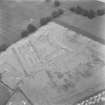
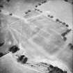
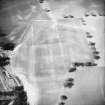
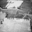
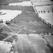
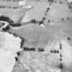
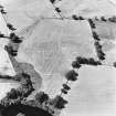
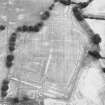
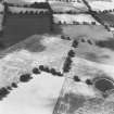
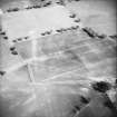
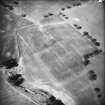
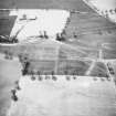
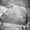
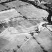
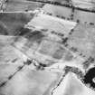
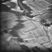
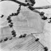
The fort is situated on a ridge which extends up to an escarpment on the W of the River Earn. The ground falls away to an unnamed burn on the S and also to the low-lying ground on the N, where the River Earn, after running E to W, turns to the S to run past the fort on the E. To the W the ground drops away very gently, and does not rise appreciably for at least 400m. Despite being under the plough, some elements of the fort are visible on the ground and are recorded on a contour survey undertaken in March 1997. The line of the rampart is clearly visible as a swelling in the surface of the ground up to about 0.8m in height, but with no visible breaks to mark the locations of the entrances. The S and W sides of the annexe can also be traced as a low spread bank, and the line of the road running into the fort through the annexes can be traced as a low gravel ridge.
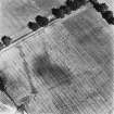
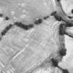
Much fine detail of the defences is visible on the aerial photographs taken prior to the campaign of excavation. The cropmarks of the rampart measure about 10m across, corresponding to the thickness of the final phase of fortification identified in the excavations. In places the outer lip of the inner ditch, which was partly built over in the final phase, can also be detected. In addition the lines of a further five defensive ditches are visible, the outer ones relating to the construction of the annexes to the W of the fort in the Antonine occupation.
Further ditches are visible as cropmarkings to the WNW and NW of the fort.
Visited by RCAHMS (DCC) 26 November 1997
S Frere and J Wilkes 1989.
Management (3 July 2000)
Scheduled (with NN81NE 2.00 and 38) as Strageath Mains, Roman fort, annexe and field system.
Information from Historic Scotland, scheduling document dated 3 July 2000.

