
Fortingall


Pit Alignment (Prehistoric), Rectilinear Enclosure(S) (Period Unassigned)
Site Name Fortingall
Classification Pit Alignment (Prehistoric), Rectilinear Enclosure(S) (Period Unassigned)
Alternative Name(s) Carn Na Marbh
Canmore ID 24995
Site Number NN74NW 39
NGR NN 741 470
Datum OSGB36 - NGR
Permalink http://canmore.org.uk/site/24995


- Council Perth And Kinross
- Parish Fortingall
- Former Region Tayside
- Former District Perth And Kinross
- Former County Perthshire
NN74NW 39 741 470
For possible barrow (Carn na Marbh) at NN 7406 4693, see NN74NW 4.
Early Christian monastic vallum (possible).
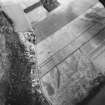
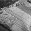
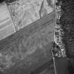
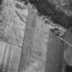
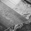
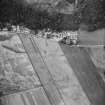
A rectilinear enclosure and a pit alignment are recorded at Fortingall. An aerial photograph taken in 1986 shows the three sides of what may be an enclosure surrounding the site of Fortingall Church. This church is thought to occupy the site of a much earlier one, and the discovery of Class III Pictish cross slab fragments in the fabric of the old church during its demolition in 1900 and the survival of a Celtic bell appear to back this up.
R Cachart 1999
Magnetometry (27 September 2010 - 29 September 2010)
NN 74186 46970 A geophysical survey was undertaken 27–29 September 2010 in the vicinity of Fortingall village, as part of a project investigating the remains of early medieval monasteries in Perth and Kinross. A fluxgate-gradiometer survey was completed over the northern half of three fields
adjacent the village to the S and in a further field, known as the ‘glebe field’, immediately to the E side of the parish church. The survey was targeted to investigate the extent and interior of a possible early medieval monastic vallum, first identified through aerial photography in the 1980s. The results confirmed the extent of the main vallum ditch and discovered several internal enclosures interpreted as forming divisions of space within the monastery precinct. The interiors of several of these enclosures were associated with multiple prominent magnetic spikes, which may indicate early medieval industrial or occupation remains. To the W the Carn Na Marbh [NN74NW 4] was shown to be a possible enclosure by an extension of the vallum with an exterior entrance point. In the glebe field a clear break in the vallum ditch was interpreted as an eastern entrance point.
Archive: RCAHMS
Funder: Society of Antiquaries of Scotland
Project (17 August 2011 - 31 August 2011)
NN 741 470 A second phase of pilot investigations, 17–31 August 2011, involved the expansion of geophysical surveys and excavation of two trial trenches over the site a possible early medieval monastery at Fortingall. The work formed part of a programme of community-based fieldwork by the Culdee Archaeology Project.
A gradiometer survey revealed a line of globular anomalies in the Glebe field E of the village, beyond the main rectilinear enclosure or vallum, which may represent prehistoric pits. A resistance survey in the field S of Fortingall hotel traced the W extent of the vallum and several internal wall or bank divisions. An L-shaped trench, 4 x 8m (Trench B), was excavated in a recently ploughed field, over a possible entrance on the SW side of the vallum, which was identified in 2010 by gradiometer survey. This revealed a section of metalled road surface flanked on the W by part of a stone lined bank, the terminus of the vallum. The remains of at least three courses of a dry stone revetment were recorded at the base of the bank terminus. At least two phases of road were noted.
A glass bead was found imbedded in the surface of the latest road. The bead was circular (12 x 7mm), but only half survives. It is composed of an opaque yellow paste body with a central perforation, light green twisted trail decoration and three circumferential parallel red bands. This has direct parallels with insular Anglo-Saxon intimation traffic light beads, which have a date range from the late 5th to 6th century AD and a distribution normally centred on SE England and E Anglia. The Fortingall bead is the most northerly example yet identified and adds to a growing body of Anglo-Saxon finds from early medieval Scotland. The find predates the suggested 7th-century date for the sculptural assemblage at Fortingall Kirk. Additional finds from Trench B included a King John English silver penny retrieved from the topsoil. Animal bone and iron slag were also found in successive layers of redeposited sand, gravel and charcoal downslope from the road and the edge of the river terrace.
An 8 x 2m trench (Trench A) was opened across the main enclosure bank, at the point where a junction with an internal division had been identified on the gradiometer survey. The well preserved remains of the base of a stone-lined bank with outer ditch were recorded, along with the rubble foundations of a small wall abutting the main bank’s inner face. The section of bank was faced with three large schist slabs, and possible post-settings were located in the bank matrix behind the slabs. The bank was 3.2m wide and composed of rounded stones in dark yellow-brown sandy silt. The ditch was buried under 0.85m of field soils, from which a green-glazed fragment of pottery, a possible copper-alloy pin head and a fragment of buckle were recovered. The ditch was 1.48m deep and 3.14m wide. A drain, lined with rounded stones and gravel, had been inserted into the base of the ditch. A single flint scraper was recovered from the drain. The edge of an apparently in situ slag deposit was also located at the eastern lip of the ditch. Bulk soil samples and charcoal samples were taken from the ditch fills for palaeoenvironmental analysis and radiocarbon dating.
Local volunteers assisted with the excavation and surveys. Two well attended open days were held with displays and site tours for the public. Pupils from Glen Lyon Primary School also took part in a day visit to learn more about the archaeology. Thanks to Breadalbane Heritage Society for voluntary help with the fieldwork and to Dr Ewan Campbell for initial identification of the bead.
Archive: RCAHMS (intended)
Funder: Society of Antiquaries of Scotland
OJT Surveys, 2011
Magnetometry (17 August 2011 - 31 August 2011)
NN 741 470 Magnetometry survey.
Archive: RCAHMS (intended)
Funder: Society of Antiquaries of Scotland
OJT Surveys, 2011
Resistivity (17 August 2011 - 31 August 2011)
NN 741 470 Resistivity survey.
Archive: RCAHMS (intended)
Funder: Society of Antiquaries of Scotland
OJT Surveys, 2011

