
Ben Lawers


Colby Camp (19th Century)
Site Name Ben Lawers
Classification Colby Camp (19th Century)
Alternative Name(s) Ben Lawers Summit, Surveyors' Campsite
Canmore ID 214839
Site Number NN64SW 3
NGR NN 63763 41298
Datum OSGB36 - NGR
Permalink http://canmore.org.uk/site/214839


- Council Perth And Kinross
- Parish Kenmore (Perth And Kinross)
- Former Region Tayside
- Former District Perth And Kinross
- Former County Perthshire
NN64SW 3 63763 41298
See also NN64SW 11.
(Location indicated at NN 6376 4129). Scheduled as Ben Lawers, campsite on the summit... built by the early surveyors of the Ordnance Survey... in a sheltered gully some 250m ESE of the summit.
Information from Historic Scotland, scheduling document dated 4 March 2002.
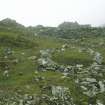
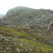
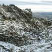
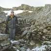
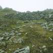
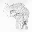
In a gully about 250m ESE of the summit of Ben Lawers there are the remains of a camp used by the Ordnance Survey during the Principal Triangulation of Britain in the mid-19th century. Camps such as these are known as Colby Camps, after Thomas Colby, Director of the Ordnance Survey from1820 to 1846. It comprises a substantial windbreak, at least four tent pitches and a stone-walled hut, all linked by a pathway.
The most striking feature of the camp is the windbreak, a curving drystone wall built across the W-facing mouth of the gully (BL00 949). It measures 13.5m in length, up to 1.3m in thickness, and 1.8m in height. Beneath its sheltered E face there is a slight hollow, measuring about 5.8m from N to S by 1.9m transversely and 0.2m in depth, from which a pathway leads E then S to end at the stone hut, about 50m from the windbreak. The pathway has been constructed with some care to maintain even gradients over the uneven gully floor; some stretches have been hollowed out of the scree, others have been built up across shallow gullies, while immediately N of the stone hut the rock face on the W side of the gully has been cut back to accommodate it. About halfway along its length, at the point where it turns to the S, a branch rises to the NE; this can be traced for about 10m before becoming lost in the scree, but it probably led onto the summit ridge and provided access to the summit itself.
The tent pitches are situated on the relatively level ground between the windbreak and the branching of the pathway. Four of them lie immediately adjacent to the N side of the path; these are no more than cleared rectangular stances, edged with stones and measuring from 2.5m to 3.7m in length and from 2.4m to 2.9m in breadth. Three of the four (BL00 951, 2035, 2036) are regularly spaced, being respectively 10m, 20m and 30m from the windbreak; the fourth stance (BL00 951), however, which is the largest, lies immediately E of the windbreak and may be a late addition.
To the S of the pathway, about 10m E of the windbreak, there are two very different structures. One (BL00 953) comprises a roughly rectangular enclosure measuring 4.2m by 2.3m within a wall of loosely piled stones 0.3m in height, and it has an entrance in the SSW side (BL00 953). Immediately to the S of it there is a platform levelled into rising ground (BL00 954). This measures 3m from NNE to SSW by 2.2m, and has a stone-revetted rear scarp 0.9m high. Around it (except at the open NNE end) there is a low spread bank, probably composed of upcast from the excavation of the platform, while a heap of loose stone in the centre of the floor may represent the remains of a recent campfire. Either or both of these features may be additional tent bases. It is possible that the platform is contemporary with the other elements of the camp, while the stone enclosure (which partly blocks access to the platform) may be of later date.
The final structure to be described is the stone hut at the SE edge of the camp (BL00 955), which may have served as the mess. It occupies a sheltered position between two shattered outcrops in the narrowest part of the gully, which has been partly infilled to provide a platform on which the hut has been constructed. It measures 4.4m from N to S by 2.6m transversely within rubble walls up to 1.2m in height. The entrance is on the W, the interior has been divided into two compartments and there is a fireplace in the N end.
The camp was probably constructed in the 1840s, and was used periodically by the OS at least until 1850 (Ferguson 1891).
(BL00 949-55, 2035-6)
Visited by RCAHMS (ATW) 22 June 2000 and (SDB) 3 September 2003
M Ferguson 1891.
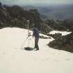
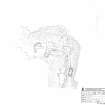
Measured Survey (September 2003)
RCAHMS surveyed the Colby Camp on Ben Lawers in September 2003 with plane-table and self-reducing alidade at a scale of 1:250.

